
A Day of Sun Smokey Skies & High Clouds Front Passes Wednesday
Dry Cool Thursday Friday

A Day of Sun Smokey Skies & High Clouds Front Passes Wednesday
Dry Cool Thursday Friday
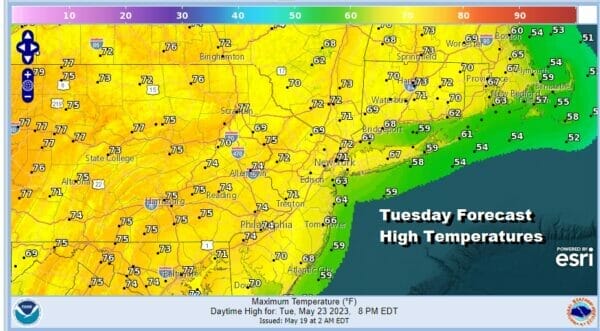
The satellite loop this morning very much sets the table for the entire day as we have some high clouds and as has been the case for a while now, smoke from the Alberta Canada wildfires. As long as the upper flow is from the northwest this is going to continue though we should catch a bit of a break Thursday into Friday. Meanwhile today it will be that milky sky of sun and smoke. High clouds from some southern moisture will move through from time to time. We also have an onshore flow and that will keep temperatures cool. Highs today will be in the mid to upper 60s along the coast and 70 to 75 degrees as you work your way further inland. We don’t think there will be any showers around today.
SATELLITE

WEATHER RADAR

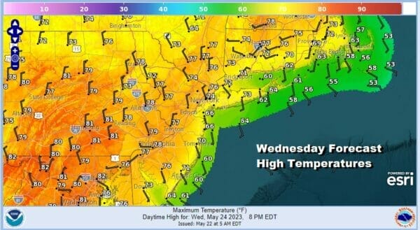
We do have a bit of a change coming for Wednesday so tonight lets call it partially clear skies with lows in the mid 40s to lower 50s. Wednesday we see a cold front that will be dropping southward from upstate NY and through New England. This front is going to have much with other than a passing shower or an isolated thunderstorm in the afternoon and early evening.

Given the front is weak it is conceivable that many folks might not see much of anything as this front is both energy and moisture starved. Given that and the fact that we will like see winds turn more westerly as the day goes on, Temperatures will warm up a bit. Highs will be in the low to mid 70s coast and upper 70s to even a few lower 80s well inland Wednesday afternoon.
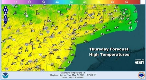
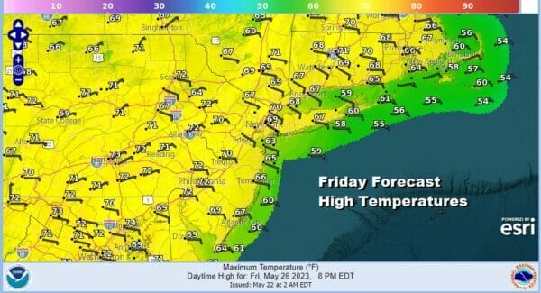
The passage of the front brings a strong high pressure area into the Northeast and Great Lakes. For the time of year, this is a rather strong high pressure cell. Also the flow aloft will turn northerly for a day or two and that should help get rid of the smoke for awhile. Thursday and Friday will both be days of sunshine but it will be on the cool side for both Thursday and Friday. Highs both days will be in the upper 60s and and lower 70s thanks to cool air and a mostly northeast wind.
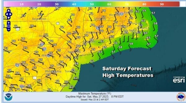
Now it is on to the Memorial Day holiday weekend. The issues are high pressure that will cover the Great Lakes and Northeast at least for Saturday so at this stage it is probably safe to say that Saturday will be a rain free day with sunshine and some high clouds that will be coming up from the south.

It won’t be a picture perfect day if you are looking for spectacular blue skies and sunshine but it will be good enough to able to do things outdoors. Temperatures Saturday will be affected by the wind coming in from the northeast and east and that should keep most highs inland in the lower 70s with 60s along the coast.
You will notice on the GFS loop above that low pressure spins up off the Southeast Coast and works its way inland and northward. An area of rain will be moving up the coast but it will also be moving into an upper high that will be nosed in from the Great Lakes and into the Northeast.
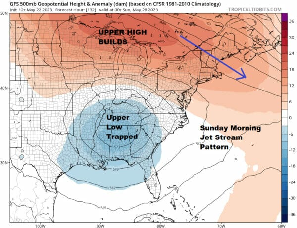
It becomes a matter of how far north the rain gets before it begins to fall apart. Some models suggest a weakening area of rain will move northward through New Jersey and Eastern Pennsylvania late Saturday night into Sunday morning before disappearing. Im not sure whether this happens or not but it does seem that even if does, it should be short lived. This probably leaves Sunday as a day of variable cloud cover with perhaps some sun breaking through the clouds. Highs will be in the 70s.

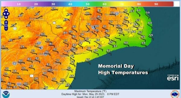
This leaves us with Monday Memorial Day and I think we will call it a day with a mix of sun and clouds. It should be warmer Monday as highs in many areas away from the ocean will be in the upper 70s to around or even just over 80 degrees. 60s though will be common along the coast.
It is probably wise if we include the possiblity of a few showers or a scattered thunderstorm in the afternoon or evening though it is conceivable that they either won’t happne or they will be few and far between. I certainly would not call the weekend a washout but it won’t be glorious. Still all in all it will be workable for most reasonable folks (are there any of those around these days?)
BE SURE TO DOWNLOAD THE FREE METEOROLOGIST JOE CIOFFI WEATHER APP &
ANGRY BEN’S FREE WEATHER APP “THE ANGRY WEATHERMAN!
MANY THANKS TO TROPICAL TIDBITS FOR THE USE OF MAPS
Please note that with regards to any severe weather, tropical storms, or hurricanes, should a storm be threatening, please consult your local National Weather Service office or your local government officials about what action you should be taking to protect life and property.
(Amazon is an affilate of Meteorologist Joe Cioffi & earns commissions on sales.)


