Weather Pattern May Go Blocky Again Next Week

Weather Pattern May Go Blocky Again Next Week
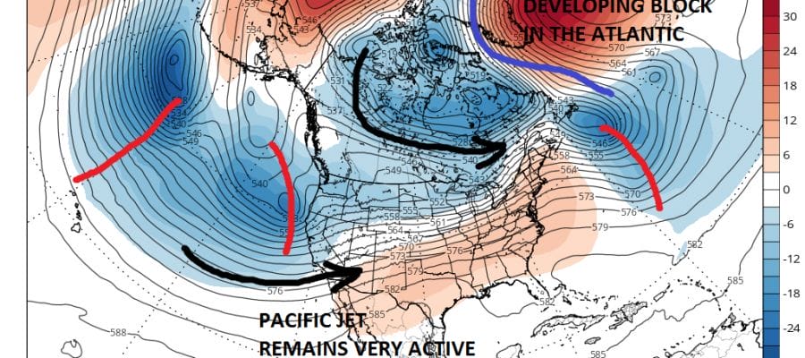
Looking ahead at the long range beyond this weekend there are some indications that the weather pattern my try and go blocky again. This time of year blocking means wetter than average conditions as well as frequent and long battles with onshore winds and days of overcast conditions. We just came out of that pattern this week and we are enjoying the payoff with warm days and a ridge in the east. However as is typical in the spring, pattern swings go from warmth to marine chilly air.
WEATHER PATTERN CHANGES GFS WEDNESDAY APRIL 19TH
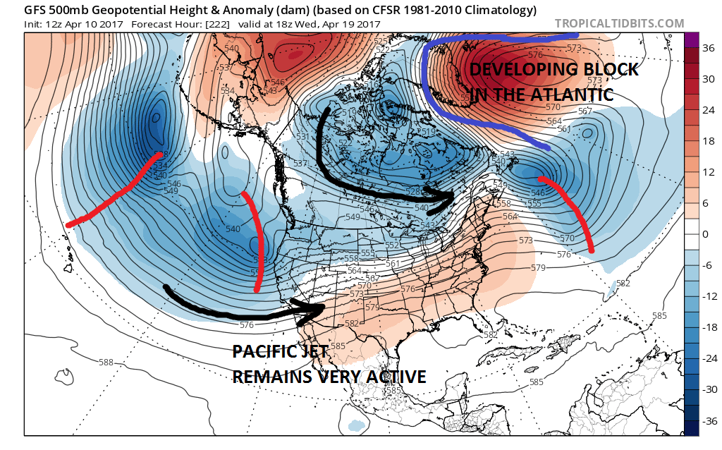
The position of the blocking high is key to what kind of weather we get here. The Pacific Jet remains as it has been for months now, very very active with weather systems continuing to move into the west. This week affords a temporary break from these systems moving across the country. Severe weather this week will be at a minimum. This pattern shift will probably increase the volume of severe weather threats later next week and beyond.
WEATHER PATTERN CHANGES GFS SUNDAY APRIL 23RD
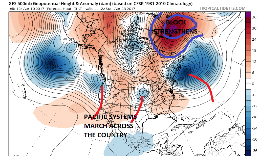
The endless march of Pacific systems across the US continues in the long term. The presence of the block would suggest chances for rain after this week. Specifics at this point are obviously difficult to come by. It does not mean that there won’t be the odd warm day here and there. There certainly should be. However if this verifies it looks like that the second half of the month may wind up being as wet as the first half for much of the Eastern US. The European weather model is going along with this idea which lends more confidence in the weather pattern going forward. In the meantime, we should enjoy the break this week with relatively dry conditions and temperatures much above average through Wednesday and back closer to average for the rest of the week.
MANY THANKS TO TROPICAL TIDBITS FOR THE WONDERFUL USE OF THE MAPS

GET JOE A CIGAR IF YOU LIKE!
LANDSCAPE COMPANIES FOR YOUR SPRING SUMMER FALL NEEDS
LONG ISLAND ROCKLAND COUNTY Connecticut

![]()

ROCKLAND COUNTY TRI STATE SNOW REMOVAL JOHNSTOWN PA


FiOS1 News Weather Forecast For Long Island
FiOS1 News Weather Forecast For New Jersey
FiOS1 News Weather Forecast For Hudson Valley
NATIONAL WEATHER SERVICE SNOW FORECASTS
LATEST JOESTRADAMUS ON THE LONG RANGE
Weather App

Don’t be without Meteorologist Joe Cioffi’s weather app. It is really a meteorologist app because you get my forecasts and my analysis and not some automated computer generated forecast based on the GFS model. This is why your app forecast changes every 6 hours. It is model driven with no human input at all. It gives you an icon, a temperature and no insight whatsoever.
It is a complete weather app to suit your forecast needs. All the weather information you need is right on your phone. Android or I-phone, use it to keep track of all the latest weather information and forecasts. This weather app is also free of advertising so you don’t have to worry about security issues with your device. An accurate forecast and no worries that your device is being compromised.
Use it in conjunction with my website and my facebook and twitter and you have complete weather coverage of all the latest weather and the long range outlook. The website has been redone and upgraded. Its easy to use and everything is archived so you can see how well Joe does or doesn’t do when it comes to forecasts and outlooks.
Just click on the google play button or the apple store button on the sidebar for my app which is on My Weather Concierge. Download the app for free. Subscribe to my forecasts on an ad free environment for just 99 cents a month.
Get my forecasts in the palm of your hand for less than the cost of a cup of Joe!
![]()
