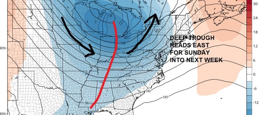
WEATHER MODELS STRONG TROUGH APPROACHING
RAIN AND THUNDERSTORMS SUNDAY AND SUNDAY NIGHT
COOL WEATHER FOR EARLY NEXT WEEK
This weekend will feature a strong trough developing in the Eastern United States. Actually we have not seen a system like this in awhile. It may open the door for some rain and thunderstorms here on Sunday. However at least with respect to the weekend Saturday looks okay with a mix of sun and clouds with highs in the 70s. Saturday will be the better of the two weekend days.
Weather Models Strong Trough Approaching Sunday NIght Upper Air
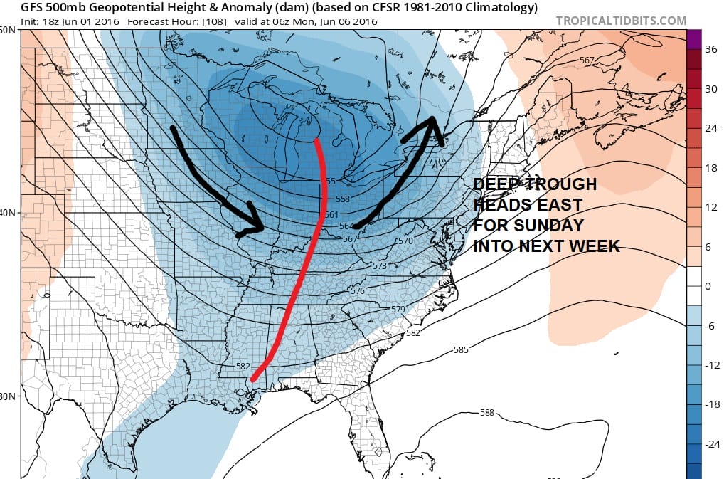
The strength of the trough is unusual for this time of year and may be a sign of a longer term change in the overall pattern across North America. The decreasing el nino influence seems to be allowing development of stronger vortex scenarios across Southern Canada. This could at least mean more frequent cold fronts and chances for rain. However we will have to also see whether the tendency for ridges to develop in the east decrease over time. This is something we will have to watch closely.
Meanwhile with regards to Sunday the trough is impressive with a strong southerly flow ahead of it into the east. This could open up a good mositure flow from the Gulf of Mexico and the Atlantic.
Weather Models Strong Trough Approaching GFS Surface Map Sunday Evening
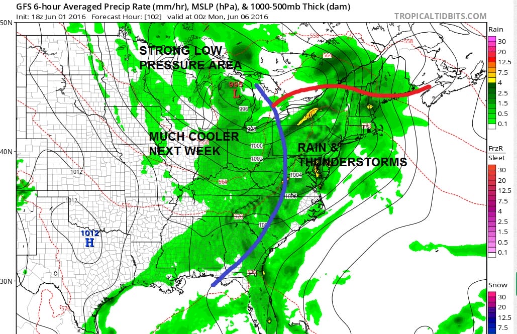
As we have seen over and over again over the last number of months, weather systems have been overdone by models with regards to rainfall production. Reality has proven to show much less than forecast. We will be cautious on how much rain falls from this until that trend of underperformance is broken.
Weather Models Strong Trough Approaching GFS RAINFALL FORECAST
The gfs model is showing about an inch or so of rain with some locally higher amounts possible. We will have to see how model trends develop before we jump totally on board with this idea.

MENTION JOE CIOFFI AND GET A 5% DISCOUNT
FiOS1 News Weather Forecast For Long Island
FiOS1 News Weather Forecast For New Jersey
FiOS1 News Weather Forecast For Hudson Valley
NATIONAL WEATHER SERVICE SNOW FORECASTS
LATEST JOESTRADAMUS ON THE LONG RANGE

NOMINATED FOR AN APPY AWARD FOR BEST WEATHER APP!!
Weather App

Don’t be without Meteorologist Joe Cioffi’s weather app. It is really a meteorologist app because you get my forecasts and my analysis and not some automated computer generated forecast based on the GFS model. This is why your app forecast changes every 6 hours. It is model driven with no human input at all. It gives you an icon, a temperature and no insight whatsoever.
It is a complete weather app to suit your forecast needs. All the weather information you need is right on your phone. Android or I-phone, use it to keep track of all the latest weather information and forecasts. This weather app is also free of advertising so you don’t have to worry about security issues with your device. An accurate forecast and no worries that your device is being compromised.
Use it in conjunction with my website and my facebook and twitter and you have complete weather coverage of all the latest weather and the long range outlook. The website has been redone and upgraded. Its easy to use and everything is archived so you can see how well Joe does or doesn’t do when it comes to forecasts and outlooks.
Just click on the google play button or the apple store button on the sidebar for my app which is on My Weather Concierge. Download the app for free. Subscribe to my forecasts on an ad free environment for just 99 cents a month.
Get my forecasts in the palm of your hand for less than the cost of a cup of Joe!
![]()

