
Weather Models Bullish Noreaster March Snow
![]()
EURO MODEL, GFS MODEL, CANADIAN MODEL ALL SHIFT LEFT
WESTERN RIDGE REMAINS KEY TO FORECAST
First off maybe I should take stands against snow more often. Models today seem to be coming together and all three models shifted to well to the left. It is clear that we see Weather Models Bullish Noreaster March Snow across the board. What is happening goes back to what we discussed yesterday.
Weather Models Bullish Noreaster March Snow YESTERDAY’S EURO MODEL UPPER AIR FORECAST FOR MONDAY MORNING
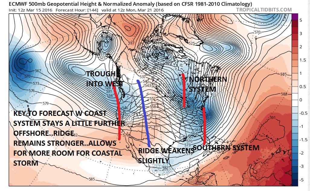
The map above was the European upper air forecast map for Monday morning. The key was the system in the west which the Euro model crashed into the coast which weakens the ridge, which in turn weakens the trough. The GFS model, Canadian model, and the NAM model tonight keep that west coast system a little further west which keeps the ridge in tact. Now comes the new European model for the same time frame.
Weather Models Bullish Noreaster March Snow TODAY’S EURO MODEL UPPER AIR FORECAST FOR MONDAY
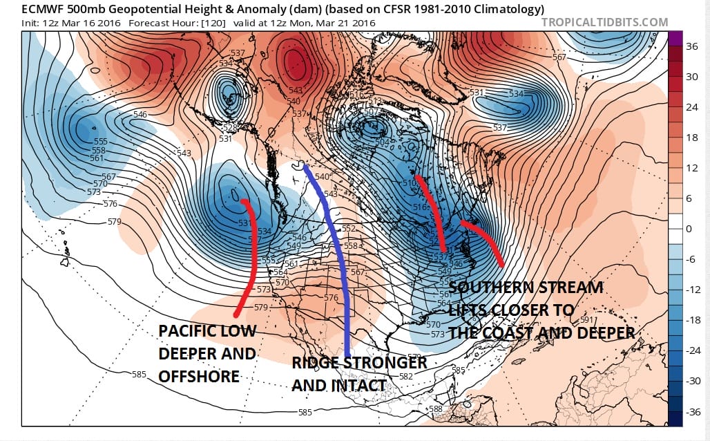
The differences in the two runs is very important. The system off the west coast is deeper and further left. This makes the ridge just a little bit stronger and the trough in the east a little bit deeper and further left. If this is correct, then the odds of a noreaster and a mid March snowstorm for the northeast are increasing. Now from this point we need to see the following.
CONFIRMATION ON THE NEXT SEVERAL MODEL RUNS
This is obvious. The fact that the models seem to be zeroing in and coming closer together is a bullish sign
NO PHASING OF THE NORTHERN AND SOUTHERN STREAM IN THE EAST
A complete phase would shift the coastal low even further west creating a coast hugger which would bring rain to the coast and shift heavy snows inland. The strongly negative NAO (North Atlantic Oscillation) would argue against this.
Weather Models Bullish Noreaster March Snow EURO MODEL SURFACE MAP FOR MONDAY MORNING
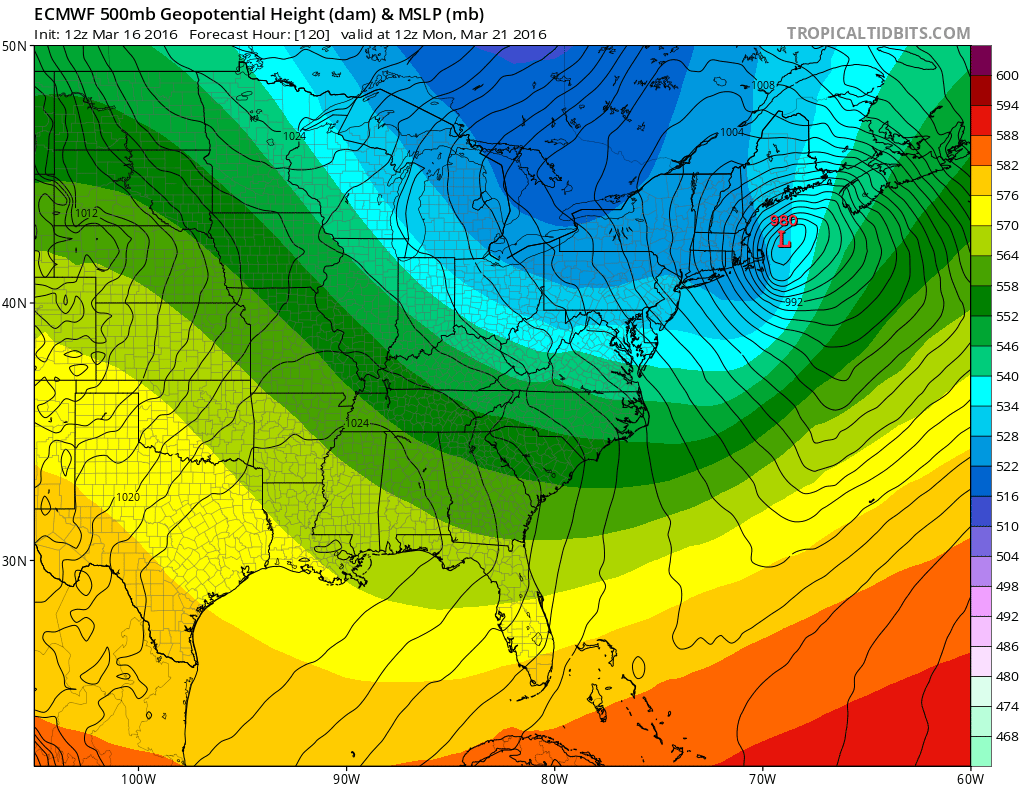
The surface map for Monday morning has a deep low northeast of Cape Cod. If the models are correct snow would develop during the mid to late afternoon Sunday and continue Sunday night and ending by daybreak Monday morning..starting and ending sooner west and south and a little late north and east. Models are fairly close on the timing. So the bulk of the precipitation falling at night is key because that will stick..assuming the models are correct.
Obviously we have a long way to go on this. I think right now that there is a chance we could have a more phased look. But it certainly appears that models seem to be coming into agreement here on the increasing chance for a noreaster this weekend and for a significant snowfall for the northeast and interior Middle Atlantic states.
Weather Models Bullish Noreaster March Snow EURO MODEL SNOWFALL FORECAST MAP ENDING MONDAY MORNING

The Euro model snowfall forecast map is the model’s view based on this run and NOT MY FORECAST.
FiOS1 News Weather Forecast For Long Island
FiOS1 News Weather Forecast For New Jersey
FiOS1 News Weather Forecast For Hudson Valley
NATIONAL WEATHER SERVICE SNOW FORECASTS
LATEST JOESTRADAMUS ON THE LONG RANGE

NOMINATED FOR AN APPY AWARD FOR BEST WEATHER APP!!
Weather App

Don’t be without Meteorologist Joe Cioffi’s weather app. It is really a meteorologist app because you get my forecasts and my analysis and not some automated computer generated forecast based on the GFS model. This is why your app forecast changes every 6 hours. It is model driven with no human input at all. It gives you an icon, a temperature and no insight whatsoever.
It is a complete weather app to suit your forecast needs. All the weather information you need is right on your phone. Android or I-phone, use it to keep track of all the latest weather information and forecasts. This weather app is also free of advertising so you don’t have to worry about security issues with your device. An accurate forecast and no worries that your device is being compromised.
Use it in conjunction with my website and my facebook and twitter and you have complete weather coverage of all the latest weather and the long range outlook. The website has been redone and upgraded. Its easy to use and everything is archived so you can see how well Joe does or doesn’t do when it comes to forecasts and outlooks.
Just click on the google play button or the apple store button on the sidebar for my app which is on My Weather Concierge. Download the app for free. Subscribe to my forecasts on an ad free environment for just 99 cents a month.
Get my forecasts in the palm of your hand for less than the cost of a cup of Joe!
![]()
