Weather Fronts Bring Down Colder Air Early Arriving Sunday Saint Patricks Day

Weather Fronts Bring Down Colder Air Early Arriving Sunday Saint Patricks Day

We have arrived at the doorstep of the weekend and we are seeing weather fronts passing through over the next couple of days. The first one is passing through today. Most of the showers with this week system have passed to our north in upstate NY and New England and there are also some that are passing to the south across Maaryland and Delaware. In between we have lots of clouds. The satellite is picking up on some breaks in the cloud cover here in there but overall I think it is safe to call this a mostly cloudy type of day. Temperatures will range from the low to middle 60s for highs NYC and points north and east to lower 70s across Southern Pennsylvania, Southern New Jersey and points southward.
SATELLITE WITH LIGHTNING STRIKES

WEATHER RADAR

It is nice to be looking ahead to a weekend where the rain risk is rather low. We do have another cold front that will pass through during Sunday. This front marks the leading edge of colder air coming into the Eastern US out of Canada and it sets up a rather cold start to next week. We do not see any major storms and we actually could be rain free through at least the middle part of next week.

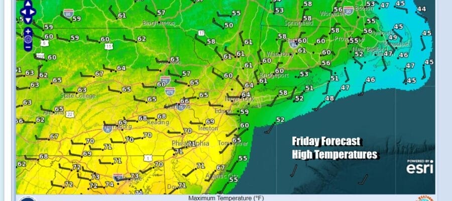
With this in mind we have some sunshine for Saturday, a day on which many Saint Patrick’s Day parades will be celebrated. It will be a dry day and relatively mild day as high temperatures Saturday will be reach into the upper 50s and lower 60s in most places. Sky conditions should be no worse than partly Sunday.

The leading edge of colder air will move Across the Great Lakes and start sweeping into the Eastern US later Saturday night into Sunday. Showers with this front will be mostly across Upstate NY and New England but there could be a few showers as the front passes which will probably be sometime during midday early afternoon.

Sunday we could see clouds for the first part of the day and then some developing sun later in the day with a shower or two in between. Temperatures will reach the upper 50s to lower 60s for highs but it will turn colder as northwest winds kick in. Most lows Monday morning will be in the 30s.
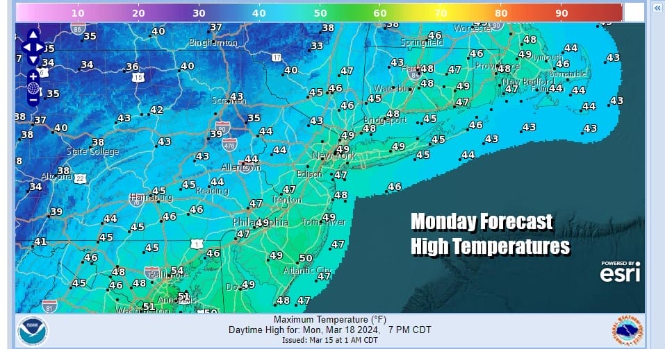
Monday, Tuesday and Wednesday will be dry cold days as we see sunshine for Monday and Tuesday and at least some sunshine for Wednesday. Highs each day will be just in the 40s which is actually 5 or more degrees below average. Nights will be down in the 20s to around 30. Tuesday looks to be the coldest day with highs just in the low to mid 40s. Wednesday we will be in the mid to upper 40s. No major storms are in the horizon and it should be dry through at least Thursday.
BE SURE TO DOWNLOAD THE FREE METEOROLOGIST JOE CIOFFI WEATHER APP &
ANGRY BEN’S FREE WEATHER APP “THE ANGRY WEATHERMAN!
MANY THANKS TO TROPICAL TIDBITS FOR THE USE OF MAPS
Please note that with regards to any severe weather, tropical storms, or hurricanes, should a storm be threatening, please consult your local National Weather Service office or your local government officials about what action you should be taking to protect life and property.
(Amazon is an affilate of Meteorologist Joe Cioffi & earns commissions on sales.)


