Last Days of Winter First Days of Spring
Will Feature Below Average Temperatures

Last Days of Winter First Days of Spring
Will Feature Below Average Temperatures

Seasons often do not find a linear path where everything goes up. Instead this is a time volatility which is why March is the most volatile month of the year. It is known for big temperature swings both up and down. Record highs one day could easily followed by record cold the next. The current weather set up is not quite as extreme but we are on our way to a colder than normal pattern over the next 5 days or so. This comes as winter is ending and spring is officially beginning Tuesday March 19th.
SATELLITE WITH LIGHTNING STRIKES

WEATHER RADAR

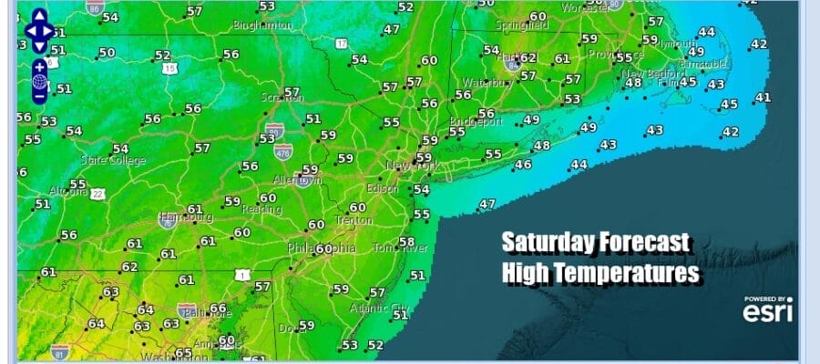
Today will be a nice day for the most part with a fair amount of sunshine and temperatures that will be reaching the upper 50s and lower 60s. Radars are nice and quiet with no worries as far as rain is concerned. This is a day where we have Saint Patrick’s Day parades going on and the weather could not be better.

Sunday we have a cold front that will passing through sometime Sunday morning or around midday. There isn’t much to this weather front other than some rain showers that will be ahead of it so we will put in the chance for a shower or two as the front passes. Then winds turn northwest and we start to see cold air slowly arriving during the afternoon and particularly Sunday night. Other than the passing shower there could be some breaks of sunshine Sunday.

Most highs Sunday will be in the mid 50s to around or just over 60 or so but this will be the last day of above average temperatures as a new pattern settles in for Monday and probably all of next week. High pressure from Central Canada moves southeast with colder than average temperatures spreading throughout the Eastern US as well as across the South and Southeast US.
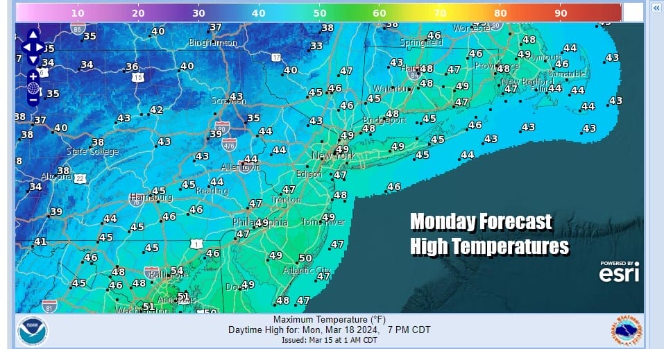
We should see a fair amount of sunshine Monday but there will be a few clouds in the mix along with a bit of a gusty wind. Highs will be in the mid to upper 40s. Tuesday, Saint Joseph’s Day, is the first day of spring and it will be cold for this time of year. Tuesday morning lows will be in the upper 20s and lower 30s and highs Tuesday afternoon will be just in the low to middle 40s.

Wednesday we will see temperatures moderate slightly with highs in the mid to upper 40s and we will have nothing worse than a mix of sun and clouds. Another weak weather front passes with some colder air behind it. It basically re-enforces the chilly air so we look ahead to dry conditions Thursday and Friday. Highs both days will be in the 40s to near 50 and their should be some sunshine on each day. Next weekend could see another front and possibly some sort of coastal low bringing rain issue up the Eastern Seaboard so that will likely be the forecast challenge for the upcoming week.
BE SURE TO DOWNLOAD THE FREE METEOROLOGIST JOE CIOFFI WEATHER APP &
ANGRY BEN’S FREE WEATHER APP “THE ANGRY WEATHERMAN!
MANY THANKS TO TROPICAL TIDBITS FOR THE USE OF MAPS
Please note that with regards to any severe weather, tropical storms, or hurricanes, should a storm be threatening, please consult your local National Weather Service office or your local government officials about what action you should be taking to protect life and property.
(Amazon is an affilate of Meteorologist Joe Cioffi & earns commissions on sales.)


