

Weather Conditions Slowly Deteriorate
Coastal Storm System Friday Night Into the Weekend
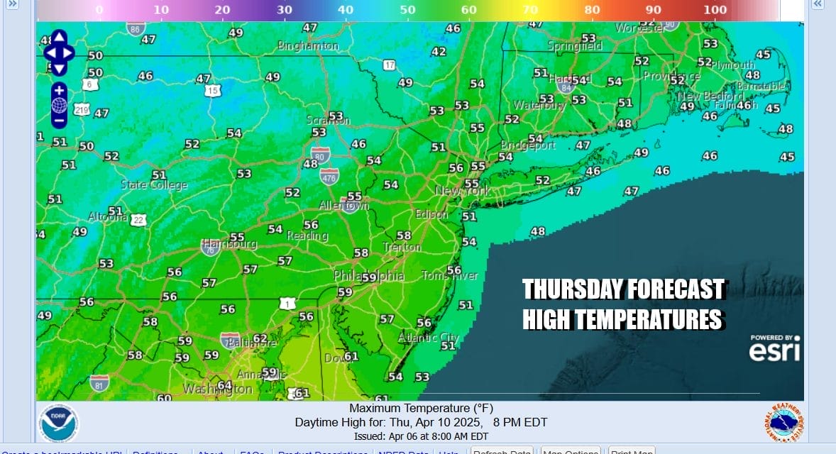
We are going to begin the decent into the gloom & doom abyss today and it will culminate in a coastal storm that will develop off the Mid Atlantic coast Friday night into Saturday. Clouds are rolling in today and radars are showing light rain to the west in Pennsylvania. We will likely see some patches of light rain this afternoon into tonight. Temperatures will reach the 50s today for the first time in 4 days.
SATELLITE WITH LIGHTNING STRIKES

WEATHER RADAR

Low pressure in the Appalachians will begin to form tonight and Friday in response to a strong upper air trough that is diving southeastward from the Plains into the Carolinas. That surface low eventually finds its way offshore Saturday. We will see patchy light rain tonight into Friday and then a steadier rain develops as the low strengthens some. That steady heavier rain will move northward late Friday and it will continue to rain steadily through Friday night into Saturday afternoon.

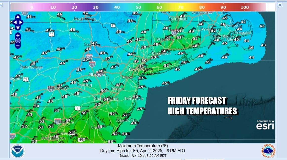
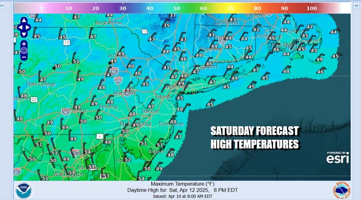
Winds will be turning to east northeast tonight and Friday and then more to the northeast Friday night and Saturday. This is going to put us right into the heart of raw conditions. Temperatures are going to struggle with highs Friday only in the upper 40s and lower 50s and Saturday temperatures will likely just hover in the 40s all day long. Some places inland and north of the coast will see temperatures hover in the low 40s all day.
With northeast winds and a coastal low to the south we will see winds pick up especially Friday night and Saturday to 20 to 30 mph with some higher gusts especially along the coast. We also have a full moon this weekend and this means we could see minor to moderate coastal flooding at high tides over the weekend.
Since we still have abnormally dry conditions if it is going to rain, let it be a steady soaking rain and not an all at once torrential type rain. We will see the former as rainfall amounts will be in the range of an inch to an inch and a half over 48 hours from this evening through Saturday evening and this should not produce any kind of street flooding or river flooding. Severe weather risks are near zero given the cool marine air conditions.

Sunday is a bit tricky Whether our weather conditions improve or not will hinge on the low offshore and how long it takes to move to the east. Low clouds will be difficult to dislodge until the storm is far enough east. Some leftover light rain or showers need to be in the forecast for now but areas to the west across Western New Jersey and Pennsylvania as well as to the northwest could see sky conditions try to improve later in the day. It is a tough call at this point. Winds will turn north and northwest and that should allow temperatures to get back into the 50s.

Monday and Tuesday we should see improving conditions overall though we do have a weather front coming through Monday night into Tuesday morning with some showers. This will be followed by another shot of colder air coming into the Eastern US for Wednesday and Thursday. Highs should be back into the 60s to near 70 degrees for Monday and Tuesday and then back down to upper 40s and lower 50s Wednesday.
BE SURE TO DOWNLOAD THE FREE METEOROLOGIST JOE CIOFFI WEATHER APP &
ANGRY BEN’S FREE WEATHER APP “THE ANGRY WEATHERMAN!
MANY THANKS TO TROPICAL TIDBITS FOR THE USE OF MAPS
Please note that with regards to any severe weather, tropical storms, or hurricanes, should a storm be threatening, please consult your local National Weather Service office or your local government officials about what action you should be taking to protect life and property.


