Weak Fronts Continue to March Through
Chance For Rain Friday Into Saturday, Snow Ice Well North

Weak Fronts Continue to March Through
Chance For Rain Friday Into Saturday, Snow Ice Well North
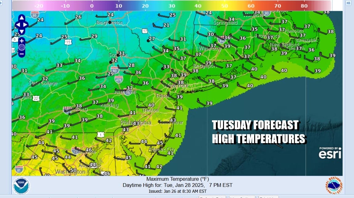
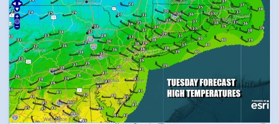
Today we have the first of two upper troughs/weather fronts that are going to be moving through the Northeast. Across Upstate NY (north and northwest of Interstate 84) we are seeing numerous snow showers and snow squalls this morning that area headed southward. However we expect this area to weaken as they move south. We will leave in the slight chance for a passing rain or snow shower in the forecast today but overall it will likely be mostly cloudy to partly sunny today. Temperatures will be mostly in the upper 30s and lower 40s.
SATELLITE WITH LIGHTNING STRIKES

WEATHER RADAR

Most lows will be in the mid 20s to lower 30s overnight under some clouds. The second upper trough will move through upstate NY and New England overnight into Wednesday morning bringing a few inches of snow in these areas. However to the south across Eastern Pennsylvania to Southern New England we will see skies become partly sunny Wednesday. Temperatures will be in the relatively warm 40s just about everywhere.

Colder air comes in Wednesday night into Thursday morning with lows in the teens to lower 20s. Thursday dayside will be sunny but cold with highs back to the 30s. This shot of cold air will try and wedge in to the Northeast Friday ahead of a storm system coming out of the Southern Plains. The low will track to the Ohio Valley and then translate itself eastward toward the Northern Appalachians.

Precipitation is set to arrive early Friday morning from west to east. Some cold spots inland might see some freezing rain at the start but for most of Eastern Pennsylvania to Southern New England, this is mostly a rain event. North of Interstate 84 in NY and New England it will be a snow and ice situation as cold air holds on in northern areas. Rain during the day Friday will come with highs in the 40s except 30s north of Interstate 84. The system moves out Friday night and we should see some improvement over the weekend with dry and somewhat colder conditions returning.
BE SURE TO DOWNLOAD THE FREE METEOROLOGIST JOE CIOFFI WEATHER APP &
ANGRY BEN’S FREE WEATHER APP “THE ANGRY WEATHERMAN!
MANY THANKS TO TROPICAL TIDBITS FOR THE USE OF MAPS
Please note that with regards to any severe weather, tropical storms, or hurricanes, should a storm be threatening, please consult your local National Weather Service office or your local government officials about what action you should be taking to protect life and property.


