Weak Disturbance Exits This Morning Improving Weather This Afternoon,
Nice Wednesday Mother’s Day Outlook

Weak Disturbance Exits This Morning Improving Weather This Afternoon,
Nice Wednesday, Mother’s Day Outlook
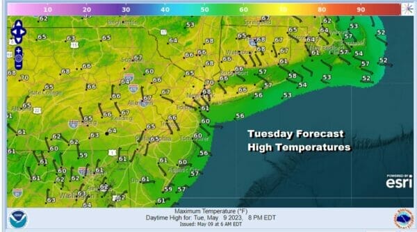
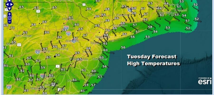
It is going to be a bit of an upside down type of day where warmer temperatures will occur as you head north into the Hudson Valley and Southern New England verses Southern New Jersey, Southern Pennsylvania southward. Clouds and a few showers will linger there and that will keep highs down in the lower 60s. To the north though with less cloud cover and developing sunshine, highs will reach 65 to near 70 degrees. A weak disturbance is moving southeast from Pennsylvania to Southern New Jersey and that disturbance will continue its slide southeast. There are some showers around on the radar but we will see those diminish as we go through the day.
SATELLITE

WEATHER RADAR

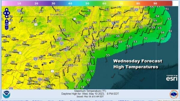
Most lows tonight will be in the 40s with a few upper 30s in the coldest areas well inland and near 50 in warmer urban locations. Wednesday looks to be a very nice day with plenty of sunshine and nothing more than a passing cloud or two. Highs will reach into the lower 70s in most places. Local sea breezes will develop along coastal locations, south and east facing shorelines.
There weather pattern for the rest of the week and into the weekend is mostly a good one. We do have a weak cold front that will come through Friday night into Saturday morning and there could be some showers with that front as it goes by but it appears to be minimal at this stage.
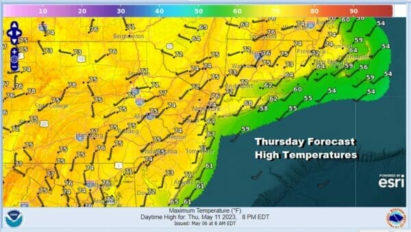
Temperatures will be trending higher Thursday and Friday and we will see sunshine on both days. Thursday might see some wispy high clouds around and there might be a cloud or two in the mix Friday but overall they will be two nice days. Temperatures Thursday will be in the mid 70s to around 80 degrees and Friday highs will be into the 80s.

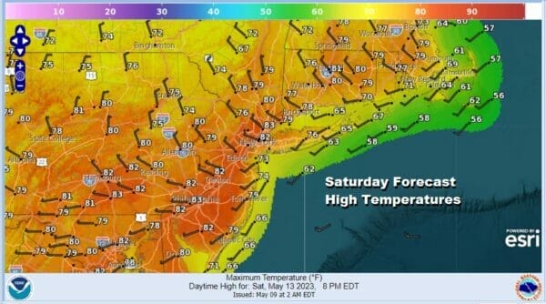
Even though we do see a weak front moving through Friday night into Saturday morning, it will be another set up where any showers likely pass more to the south and don’t amount to much. There will be some leftover warm air around Saturday so if there are some clouds around early in the day they should give way to sunshine and highs Saturday will be in the 80s.
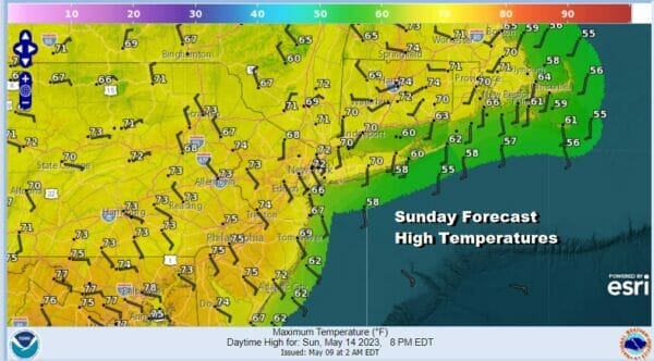
Sunday is Mother’s Day and we will be looking at a day where weak high pressure will hold on just enough to keep the day dry. I would describe it as a day where we have some sunshine along with some arriving clouds. Temperatures Sunday will be cooler than Saturday with most highs in the upper 60s to middle 70s with cooler readings along the shore.
A fast moving low and cold front will approach Sunday night and Monday and with that front we will see some showers but they should hold off until later Sunday evening at the earliest. The last two years, mother’s day was not good weather wise but it does look like this year it will be a bit different and a lot better.
BE SURE TO DOWNLOAD THE FREE METEOROLOGIST JOE CIOFFI WEATHER APP &
ANGRY BEN’S FREE WEATHER APP “THE ANGRY WEATHERMAN!
MANY THANKS TO TROPICAL TIDBITS & F5 WEATHER FOR THE USE OF MAPS
Please note that with regards to any severe weather, tropical storms, or hurricanes, should a storm be threatening, please consult your local National Weather Service office or your local government officials about what action you should be taking to protect life and property.


