Watching Pattern Change Underway
Watching Pattern Change Underway
Rainy Late Next Week?
Also Watching Tropics
The last few days have been very frustrating watching models especially the GFS model flipping back and forth regarding a blocking pattern setting up later next week. Model volatility is always high during pattern changes but it seems that the European model has been more consistent the last few days and the GFS now seems to be following the European Model’s lead in all this. Of course now that the European model’s afternoon run is coming in, it is doing exactly the opposite! We also think that with the evolving pattern that we should watch the tropics. Right now there are no tropical systems that are even on the map. However my one concern is should a tropical system make an appearance around the time of this pattern shift, it could make things a bit more interesting.

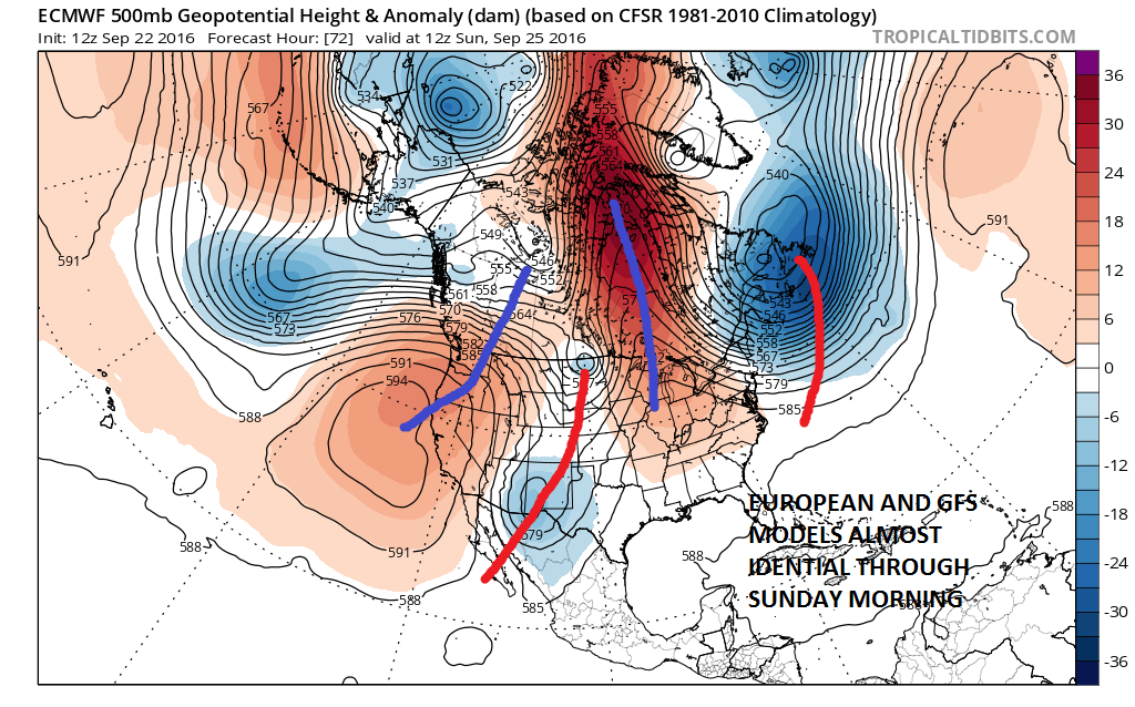
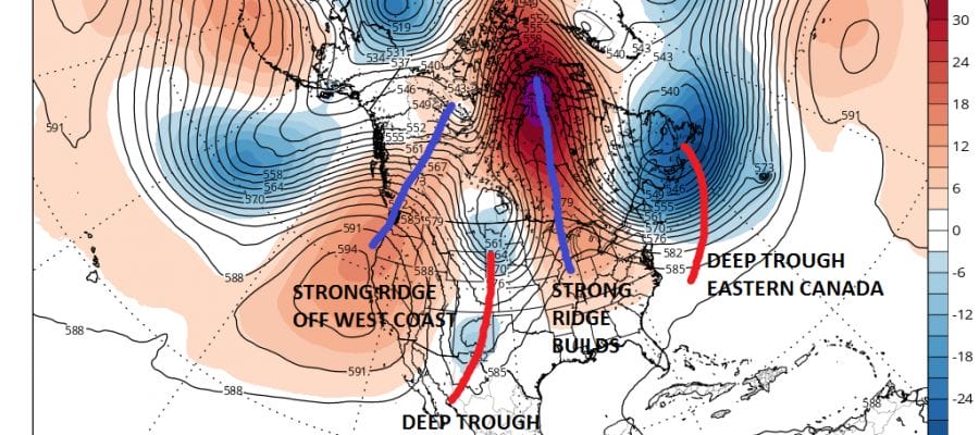
Both the European model and the GFS are virtually identical through Sunday morning with the deep storm near Northeastern Canada and another deep trough into the Northern Plains through the Southern Rockies. Big ridges are on both models in the west and in Eastern Canada near Hudson Bay. This supports the shot of cooler air coming into the Northeast and sinking southward into the Middle Atlantic States. After this period the models start to separate.
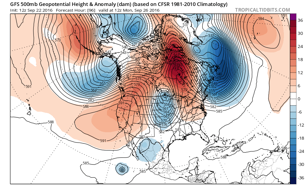
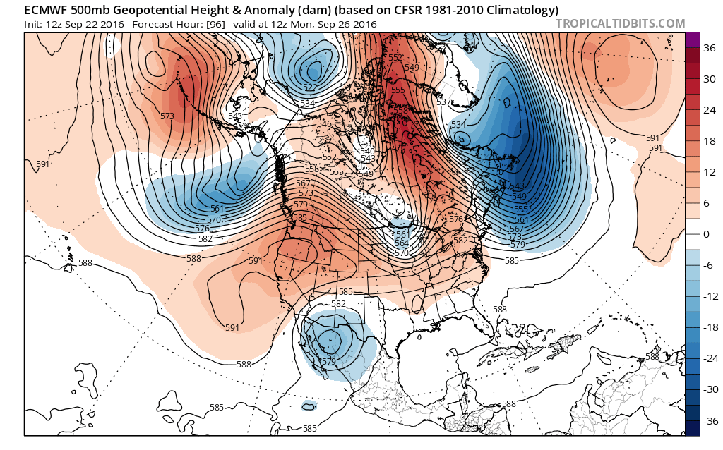
The GFS model seems to be going toward the European Model’s idea yesterday with deep troughs on either side of us and we are sitting in between. The European drops the southern part of the trough into the Southwest which makes for a much weaker system approaching the Great Lakes. Both models have the deep upper air storm in the Northwest Atlantic and that storm will be key going forward for later in the week.
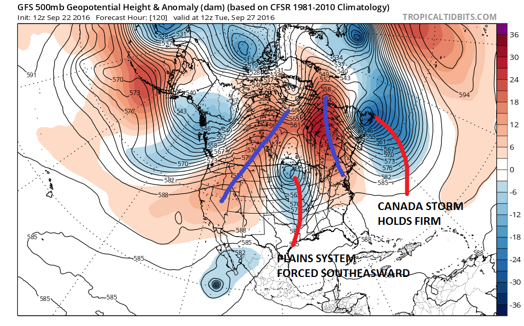

But the confusion continues as the European Model begins to stretch the trough southwestward by Wednesday. This forces it to drop southeastward toward the Ohio Valley. The GFS gets to the same idea only it does it in a different way. The bottom line is that the models are showing high volatility from run to run which is going to make the longer range forecast extremely difficult beyond Tuesday of next week. By Wednesday the model differences are astounding in the Eastern United States.
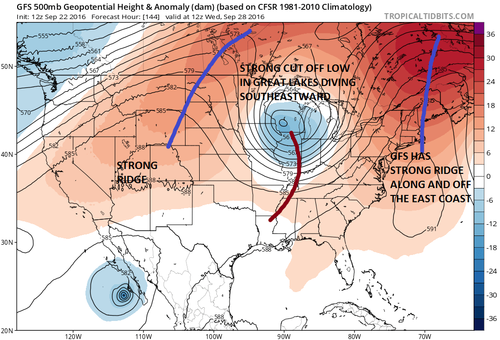

The GFS model & European Model are the same in the west and they are completly different in the East by next Wednesday. Where the GFS has a big warm ridge along the east coast, the European has a trough and strong westerly winds across the Middle Atlantic States. The GFS has a developing south southwest flow inland and west of the coast, while the European has a west northwest flow with a disturbance swinging southeast! You would have 2 completely outcomes depending on which model you use!


Now we move to next Friday where the GFS would have us under a driving rain event with low pressure developing to our south and a strong onshore flow. The European has a simple cold front moving through the day before and then drying out on Friday!
Here are my take aways from this. Based on what we are sure of it will be dry through at least Tuesday and possibly Wednesday. Temperatures will be cool into Tuesday. That part is settled. After that we can pretty much toss things in the air. The GFS presents an upper air pattern which could be rather dangerous if a tropical storm were to burst on the scene. In fact today’s model continues the trend of the last few days of developing a tropical storm and bringing it to just east of the Bahamas later in this timeframe. The European model SHOWS NO TROPICAL SYSTEM AT ALL. I think the biggest key to all this is going to be the storm near Labrador and whether that storm pulls out or stalls out. Obviously the period of pattern change is going to continue to create huge model volatility from run to run. Until we can sense some form of consistency, we will just sit back and enjoy the Autumn cool weather this weekend. while watching these crazy models.

MENTION JOE CIOFFI AND GET A 5% DISCOUNT
In case you missed them, the first 3 parts of my Winter 2016-2017 preview are up and the links are below with videos that go with them.
WINTER 2016-2017 PART 1 OCEAN WATER TEMPERATURES
WINTER 2016-2017 PART 2 ARCTIC SEA ICE AND SIBERIAN SNOW COVER
WINTER 2016-2017 PART 3 NEW JERSEY PREVIEW
FiOS1 News Weather Forecast For Long Island
FiOS1 News Weather Forecast For New Jersey
FiOS1 News Weather Forecast For Hudson Valley
NATIONAL WEATHER SERVICE SNOW FORECASTS
LATEST JOESTRADAMUS ON THE LONG RANGE

Weather App

Don’t be without Meteorologist Joe Cioffi’s weather app. It is really a meteorologist app because you get my forecasts and my analysis and not some automated computer generated forecast based on the GFS model. This is why your app forecast changes every 6 hours. It is model driven with no human input at all. It gives you an icon, a temperature and no insight whatsoever.
It is a complete weather app to suit your forecast needs. All the weather information you need is right on your phone. Android or I-phone, use it to keep track of all the latest weather information and forecasts. This weather app is also free of advertising so you don’t have to worry about security issues with your device. An accurate forecast and no worries that your device is being compromised.
Use it in conjunction with my website and my facebook and twitter and you have complete weather coverage of all the latest weather and the long range outlook. The website has been redone and upgraded. Its easy to use and everything is archived so you can see how well Joe does or doesn’t do when it comes to forecasts and outlooks.
Just click on the google play button or the apple store button on the sidebar for my app which is on My Weather Concierge. Download the app for free. Subscribe to my forecasts on an ad free environment for just 99 cents a month.
Get my forecasts in the palm of your hand for less than the cost of a cup of Joe!
![]()

