
Warmup Begins No Rain Until Thursday Night & Friday, Weekend Mostly Dry

Warmup Begins No Rain Until Thursday Night & Friday, Weekend Mostly Dry
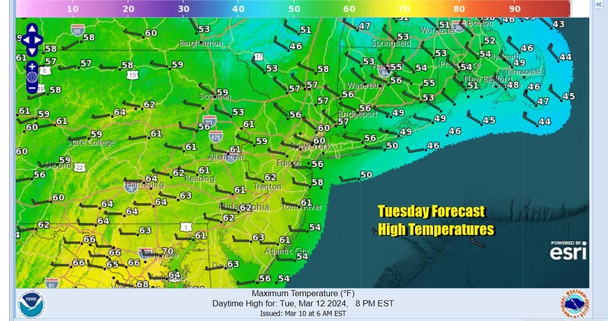
One thing about this time of year is that when colder air masses pull out, the bounce higher comes in quickly. The colder the air mass, the bigger the bounce. Yesterday’s screaming 50 mph wind gusts are long gone but it will still be on the breezy side today. We will have plenty of sunshine as satellite loops show the old storm system in Atlantic Canada well to the east. High temperatures this afternoon will easily be 10 degrees higher than Monday and we will reach the upper 50s and lower 60s today in most places. No sea breeze is forecast since the west wind will be strong enough to keep sea breezes away so the coast and inland areas will see similar temperatures.
SATELLITE WITH LIGHTNING STRIKES

WEATHER RADAR

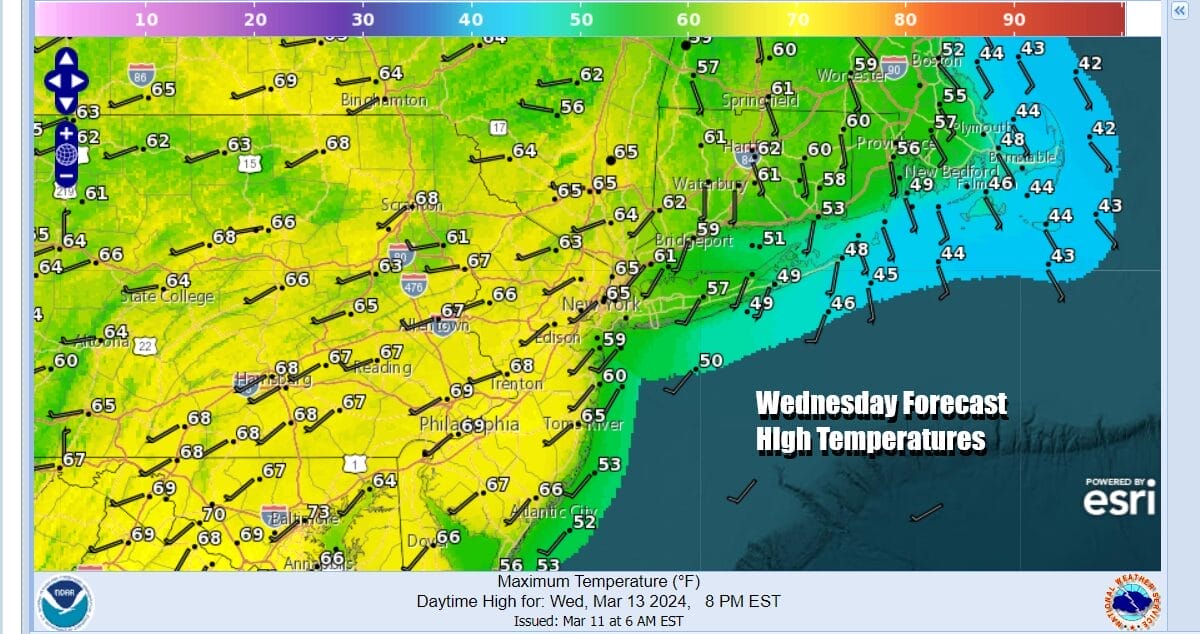
Also the air is dry so radars will remain nice and quiet for the next couple of days. High pressure moves offshore the Mid Atlantic states tonight and Wednesday so the warm up continues. Most lows tonight will be in the mid 30s to low 40s but cold spots especially east of NYC could radiate down into the 20s. Wednesday dayside will be a warm day with sunshine and highs well into the 60s.
While the wind will have a westerly component inland, along the coast (south and east facing shorelines) will be dealing with more of a south wind so those areas will likely top out in the 50s however just inland of the coast we will see highs in the mid to upper 60s. In fact it is possible that one or two warm spots could hit 70 degrees.

We do not see any widespread heavy rain events but we do have a couple of weaker systems to deal with. The first approaches late Thursday and tracks mostly to the north across Upstate NY and New England. These areas could see some clouds and showers late Thursday into early Friday. However the showers should pass to the north of Eastern Pennsylvania to Southern New England.
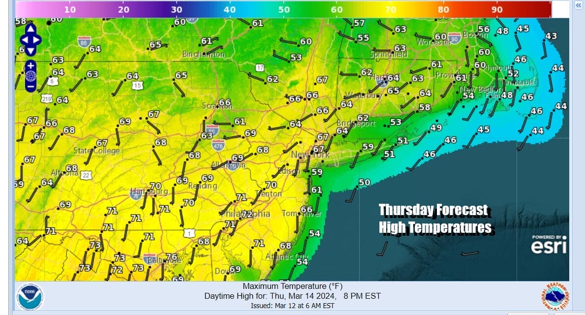
i think this should leave us Thursday with sunshine giving way to arriving clouds. However there should be enough sun to take inland temperatures into the lower 70s at least while the coastal areas deal with more ofa south wind especially later in the day so temperatures in these areas will be about 10 degrees cooler. Showers Thursday night pass to the north.

Another low approaches Friday from the Ohio Valley with a trailing cold front so we will clouds and the risk for showers Friday afternoon into Friday night. Most highs will be in the mid 60s to lower 70s inland and cooler at the coast. Showers Friday night should end before midnight from west to east. The weekend is shaping up to be mostly dry before another cold front arrives late Sunday. Behind this front we will see a colder air mass building in from Canada and that will put us in a below normal temperature pattern for much of next week.
BE SURE TO DOWNLOAD THE FREE METEOROLOGIST JOE CIOFFI WEATHER APP &
ANGRY BEN’S FREE WEATHER APP “THE ANGRY WEATHERMAN!
MANY THANKS TO TROPICAL TIDBITS FOR THE USE OF MAPS
Please note that with regards to any severe weather, tropical storms, or hurricanes, should a storm be threatening, please consult your local National Weather Service office or your local government officials about what action you should be taking to protect life and property.
(Amazon is an affilate of Meteorologist Joe Cioffi & earns commissions on sales.)


