Warmer Temperatures Move In But
Rain in the Forecast Friday Night into Early Saturday

Warmer Temperatures Move In But
Rain in the Forecast Friday Night into Early Saturday

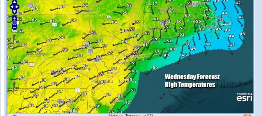
Now that the strong winds are gone we are settling into warm late winter/early spring weather. Low pressure is moving away from Nova Scotia and we saw temperatures jump higher yesterday. The uptrend continues today across the Northeast and Northern Middle Atlantic states. High pressure to the south and a west wind, coupled with sunshine will take temperatures up to the mid 60s to lower 70s inland today while along the coast we will see highs about 10 degrees lower as local sea breezes develop during the afternoon. Radars are nice and quiet and we continue to enjoy rain free conditions.
SATELLITE WITH LIGHTNING STRIKES

WEATHER RADAR

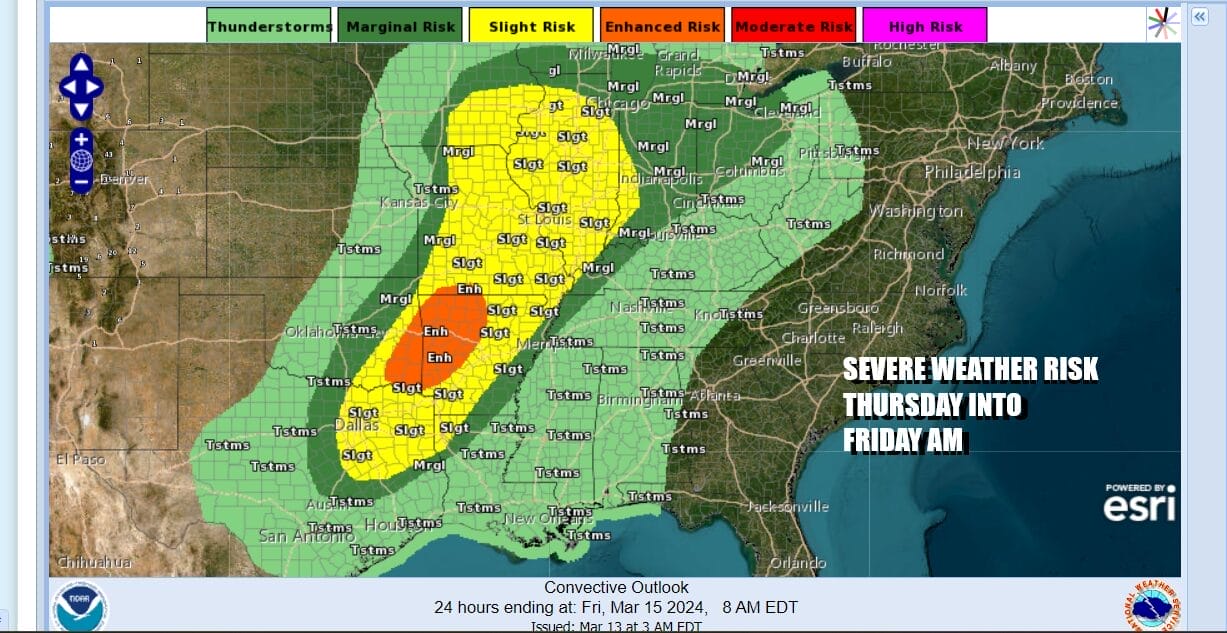
While much of the Eastern US is enjoying quiet weather, the March lion is roaring in the Western US especially in the Central and Southern Rockies as well as parts of the Southwest US where a winter storm is getting underway. Heavy snow will produce up to several feet in the mountains of Colorado and bring cities like Denver their biggest snowfall of the winter season. This is going to set off severe weather risks Thursday up and down the Mississippi River Valley along with elevated tornado risk.

All of the action in the Western US is keeping major storms and even the minor ones away at least for another day. Thursday is setting up as a day of sunshine and warm temperatures. Winds will be turning more to the south rather than southwest or west and that will limit the upside. We also could see some clouds come in late in the day as the next low pressure area heads to our north. Highs Thursday will be in the 70s inland but it will be 10 degrees cooler for areas that have south and east facing shorelines.

Most of the energy with the Rockies snowstorm will remain in the Southwest US for several days ore more and only small pieces of that system are getting ejected eastward. We also have the jet stream pattern changing Friday and over the weekend as a deep trough sets up in the Eastern US, opening up a flow of colder air to eventually spread into the Eastern and Southern US next week.

Thursday night into Friday showers will spread across Upstate NY and New England which will then be followed by a cold front that will move through Friday night into Saturday morning. Look for some patchy showers during the day Friday from Eastern Pennsylvania to Southern New England with most temperatures in the 60s to around 70 degrees. Then for the weekend, it should be mostly dry. We have a another front that will pass Saturday night with perhaps a shower. Sunday we see the beginning of a stair step decline in temperatures. Saturday and Sunday highs will be in the 50s to around 60. The coldest air will come for the first part of next week and while we will see temperatures go below average, it doesn’t appear to be anything extreme. Tuesday and Wednesday of next week will be the “coldest” days with cold air pushing down even into the Deep South. No major storms are on the horizon for time being.
BE SURE TO DOWNLOAD THE FREE METEOROLOGIST JOE CIOFFI WEATHER APP &
ANGRY BEN’S FREE WEATHER APP “THE ANGRY WEATHERMAN!
MANY THANKS TO TROPICAL TIDBITS FOR THE USE OF MAPS
Please note that with regards to any severe weather, tropical storms, or hurricanes, should a storm be threatening, please consult your local National Weather Service office or your local government officials about what action you should be taking to protect life and property.
(Amazon is an affilate of Meteorologist Joe Cioffi & earns commissions on sales.)


