Warming Up Next Few Days Rain Friday & Rain Chances Over the Weekend

Warming Up Next Few Days Rain Friday & Rain Chances Over the Weekend
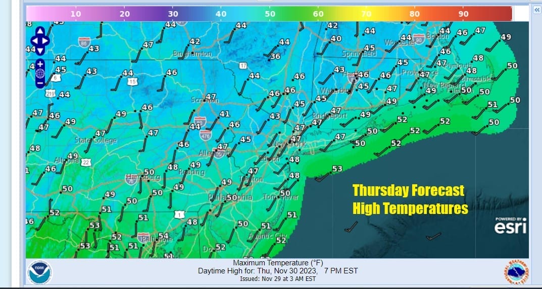
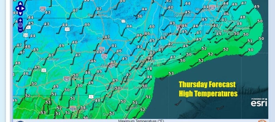
The core of the recent cold air mass is moving out today and that will allow temperatures to bounce higher to where they should be for this time of year. Satellite and radar loops indicate no issues today and we should see plenty of sunshine with a southwest wind. That will allow temperatures to bounce up to the middle and upper 40s this afternoon with a few warmer spots in Southern Pennsylvania and Southern New Jersey to reach up to about 50 or so.
SATELLITE WITH LIGHTNING STRIKES

WEATHER RADAR

Warmer days mean nights that won’t be as cold so under clear skies for much of the overnight, lows will be in the 20s inland but mostly mid to upper 30s everywhere else including warmer urban areas. Clouds will move in from west to east around daybreak or so as low pressure moves out of the Southern Plains and pushes into the Ohio Valley.

This is actually the first of several rounds of energy coming out of the Southwest and into the Northeast. Rain will develop from west to east late Friday morning into the afternoon and it should be mostly done by early Saturday morning. Friday highs will be in the upper 40s to middle 50s from north to south.

Saturday we have a second wave that will be moving from southwest to northeast but this wave is not as well developed so much of the dayside should see variable clouds and perhaps a few breaks of sun. Highs will be in the 50s to around 60 degrees. Some bands of showers will move through Saturday night into early Sunday morning.
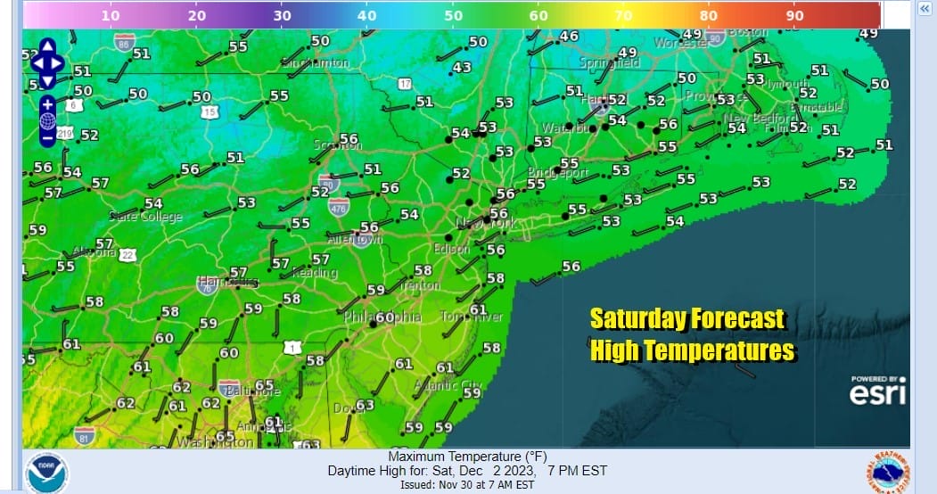
A third wave and cold front will approach and if it times right, the dayside Sunday should be dry and we could see another round of showers late in the day and overnight Sunday night into early Monday morning. Temperatures on Sunday will be lower than Saturday with highs in the 50s.

We will chill down somewhat starting Monday and there might be one more system to get through and that would be Tuesday into Wednesday but there is some question about whether there will be enough room for this and it also appears to be on the weakish side. As far as rainfall amounts are concerned, if you add all three weather systems together, maybe you get a quarter of an inch of rain. This doesn’t appear to be any big deal. Rainfall amounts from Southern New England to Long Island eastward could be on the order of a quarter to a half inch. Again this is not a big deal.
BE SURE TO DOWNLOAD THE FREE METEOROLOGIST JOE CIOFFI WEATHER APP &
ANGRY BEN’S FREE WEATHER APP “THE ANGRY WEATHERMAN!
MANY THANKS TO TROPICAL TIDBITS FOR THE USE OF MAPS
Please note that with regards to any severe weather, tropical storms, or hurricanes, should a storm be threatening, please consult your local National Weather Service office or your local government officials about what action you should be taking to protect life and property.
(Amazon is an affilate of Meteorologist Joe Cioffi & earns commissions on sales.)


