
Warming Up Ahead of a Back Door Front Mid Week Severe Weather Risk Sunday

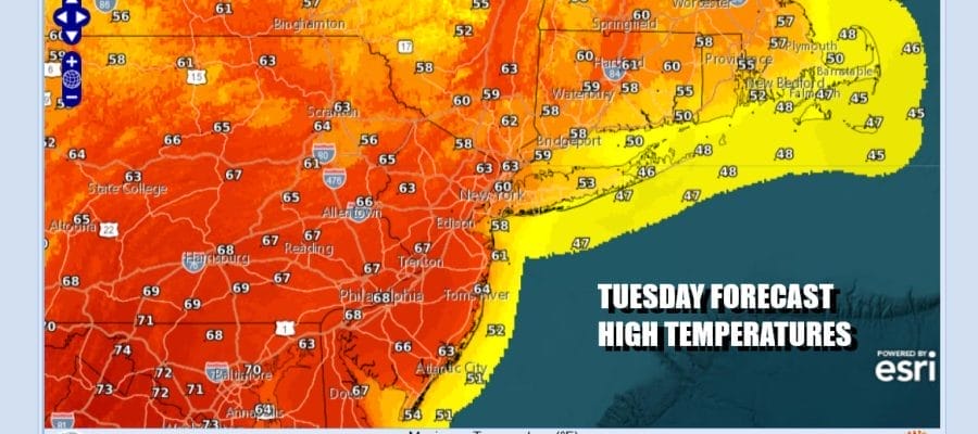
We have a warm day ahead of us with lots of sunshine and temperatures that will be topping out in the 60s. I would not be surprised if some warm spots in South Jersey and Southern Pennsylvania southward see temperatures touch 70 degrees. Radars are nice and quiet and we have a storm offshore to the southeast and a system in Southeastern Canada so we are right in between in the sweet spot.
SATELLITE WITH LIGHTNING STRIKES

WEATHER RADAR

Winds will shift to the northeast tonight as a back door front drops southward from New England and then winds up across Virginia and the Delmarva Peninsula Wednesday. Most lows Wednesday morning will be in the 30s across Eastern Pennsylvania to Southern New England with low 40s South Jersey south. Wednesday dayside will be partly sunny with an onshore wind. Highs will be in the low to mid 50s coast and upper 50s and lower 60s well inland.

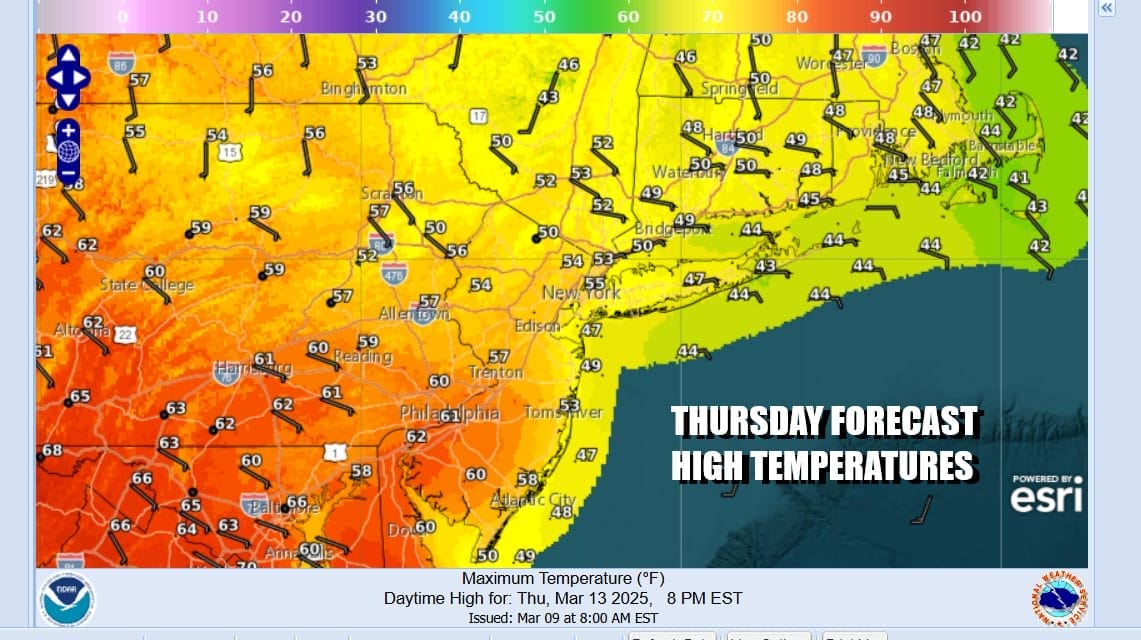
Onshore winds can be problematic in the spring as they can bring low clouds, drizzle, and raw conditions. We might see some of this along the coast Wednesday night into Thursday. The dayside Thursday is likely to see a wide range in temperatures from the 40 in Southeast New England to the 60s well inland west and south. Skies will be cloudy to partly sunny with varying conditions depending on where you are.
Temperatures will start to edge higher Friday into Sunday and we will see dry conditions into the first part of Sunday. A powerful storm is forecast to develop in the Plains and head for the Great Lakes over the weekend. We could see see a widespread severe weather outbreak Friday night in the Mississippi Valley, Saturday it moves east to the Ohio Valley to the Gulf States. Sunday it shifts to the Eastern Seaboard and we could see strong storms from New Jersey to coastal Georgia.

Friday we will see some sunshine with highs from the mid to upper 50s coast and low to mid 60s inland. Saturday looks good with no worse than partly sunny with highs again 50s coast and 60s inland. Sunday brings clouds, strong south winds, and showers and thunderstorms late Sunday into Sunday night before we dry out as we head into next week.
BE SURE TO DOWNLOAD THE FREE METEOROLOGIST JOE CIOFFI WEATHER APP &
ANGRY BEN’S FREE WEATHER APP “THE ANGRY WEATHERMAN!
MANY THANKS TO TROPICAL TIDBITS FOR THE USE OF MAPS
Please note that with regards to any severe weather, tropical storms, or hurricanes, should a storm be threatening, please consult your local National Weather Service office or your local government officials about what action you should be taking to protect life and property.


