
Warmer Temperatures Into Tuesday
Before Backdoor Cold Front Cools Things Down
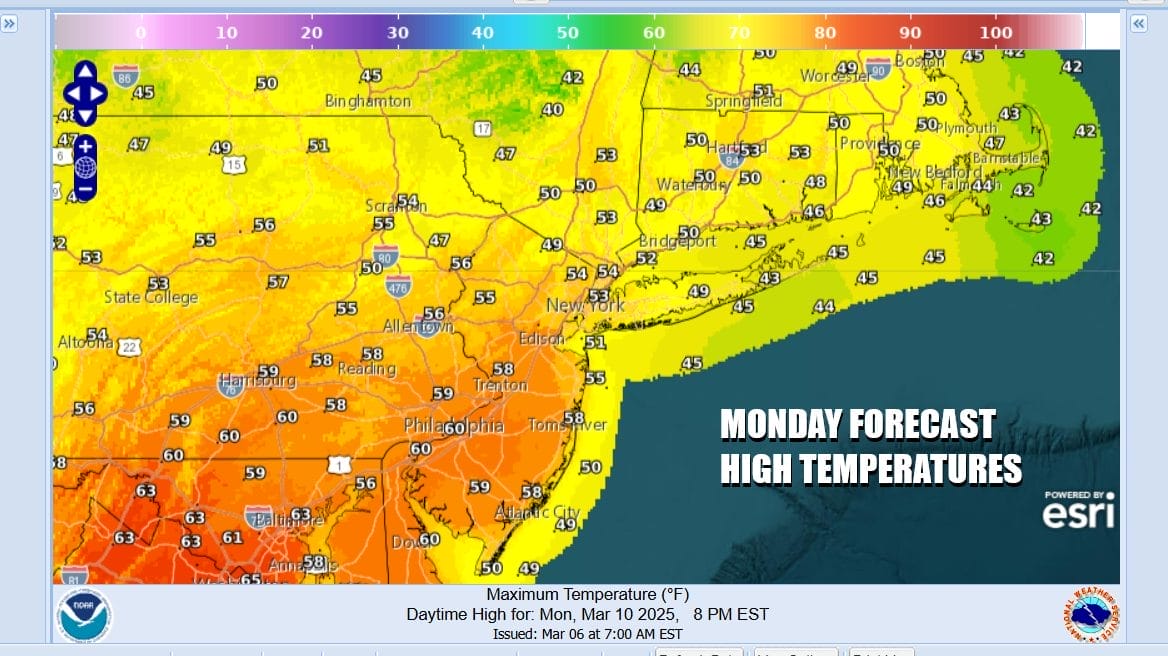
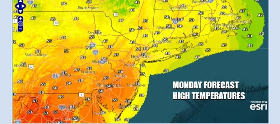
We have a nice start to the weather this week. A disturbance is passing through Northern New England and a storm system is moving through the Eastern Gulf States and off the Southeast US Coast. Since we do not have any mechanism to bring this system up the east coast we are in the sweet spot between the two. This is going to be a mice partly to mostly sunny day and temperatures will be on the rise. Most highs will be in the upper 50s north of NYC and lower 60s to the south. Coastal areas will have local sea breezes that will cool things off this afternoon. Radars are nice and quiet with no issues.
SATELLITE WITH LIGHTNING STRIKES

WEATHER RADAR

The week ahead is about warm weather on either side and sandwiched in between is a back door cold front that will pass southward Tuesday night and settle in the Mid Atlantic Wednesday into Thursday before it starts the trip back northward. There isn’t a lot of moisture around this week so the issue will be whether we get into some mid week cloud cover. No rain is forecast from this back door cold front.

A storm system in the Pacific will be coming into California Thursday and eventually this low becomes a major storm in the Rockies and Plains Friday and Saturday. The trailing cold front will set off severe weather risks Friday into Saturday in the Lower & Middle Mississippi Valley and in the Central and Eastern Gulf States Saturday into Sunday morning. The cold front will bring the next chance for showers and thunderstorms to the Northeast and Middle Atlantic states Sunday.

It is a long way from now until Sunday so we will see warmer temperatures Tuesday. Sunshine will take highs to the middle and upper 60s. I wouldn’t be shocked to see some areas touch 70 degrees. Shore locations will have local sea breezes. Wednesday we have a northeast to east wind and some sunshine so it will be at least 10 degrees colder in most places. Highs will be mainly in the 50s.

Thursday is going to be one of those days where the region sees a wide spread in temperatures. Areas from NYC and Long Island north and east will see highs in the upper 40s to lower 50s. Areas from Philadelphia & South Jersey south and west will be in the low to middle 60s, depending of course on where that back door front lies. Friday we will see temperatures cooler in eastern areas and warmer to the west. The range will be 50s except from Western New Jersey west which will reach the low and middle 60s. No rain is forecast until later Sunday into Sunday evening when a strong cold front approaches and moves through.
BE SURE TO DOWNLOAD THE FREE METEOROLOGIST JOE CIOFFI WEATHER APP &
ANGRY BEN’S FREE WEATHER APP “THE ANGRY WEATHERMAN!
MANY THANKS TO TROPICAL TIDBITS FOR THE USE OF MAPS
Please note that with regards to any severe weather, tropical storms, or hurricanes, should a storm be threatening, please consult your local National Weather Service office or your local government officials about what action you should be taking to protect life and property.


