
Backdoor Front Brings Cooler Temperatures Storm System Heads East For Sunday

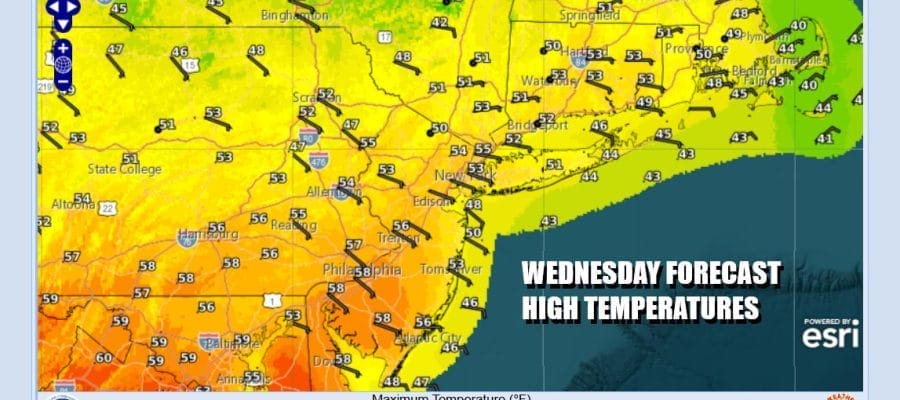
The backdoor cold front we have been speaking of the last few days has passed and moving southward into the Mid Atlantic states. Winds have shifted to the north and they will turn more northeast and east over time today. The air coming from the high pressure area to the north is dry so we should see a fair amount of sunshine today. Temperatures will be some 10 to 15 degrees lower as highs will be mostly in the 50s and closer to 50 or even the 40s along the immediate coast. Radars are nice and quiet will remain so.
SATELLITE WITH LIGHTNING STRIKES

WEATHER RADAR

Over the next couple of days the high to the north will be the primary driver of our weather. More of an east wind tonight into Friday will probably bring in some clouds overnight from the east but it will not be enough to mask the sunshine completely over the next couple of days. The next primary system that will be of impact is low pressure now moving into California where heavy rain and snow will spread eastward into the Rockies.

Eventually the California storm will reform east of the Rockies and become a major storm that will be heading from the plains to the Western Great Lakes. The trailing cold front will become a big severe weather producer. First in line will be the Mississippi River Valley from the Gulf States to the Lower Lakes Friday and then spread east into the rest of the Ohio Valley and Deep South. Finally the severe weather risks reach the East Coast from Georgia to Southern New England Sunday.
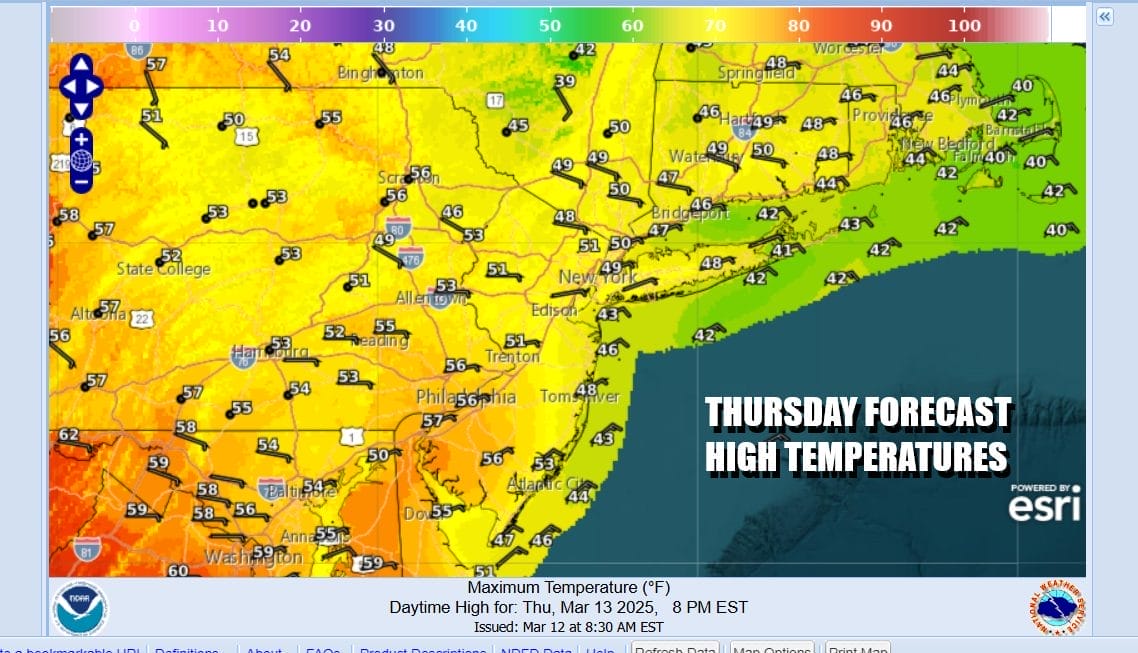
Thursday and Friday will be okay but not perfect. We will have some nighttime and morning low clouds that should burn off to some sunshine. Thursday highs will be in the 50s inland but only in the 40s along the coast. Friday will be about the same as the front to the south begins to push northward. Look for clouds and some sun and highs again Friday will be mostly in the 50s.

Saturday we will begin to see the effects from the strong cold front to the west. That means the old back door cold front becomes a warm front that moves northward. Winds shift to the south and southwest. Temperatures will be on the rise. Saturday will be dry with some sunshine and temperatures will be back in the 60s. 50s will coming along the coast and Southern New England.

Sunday will be windy and warm. The Storm Prediction Center has already indicated a “slight” risk for severe weather late in the day as the front arrives so prepare for showers and thunderstorms Thursday afternoon and evening. Sunday highs will be in the 60s with some inland highs near 70 while the wind off the ocean will keep the coast a bit cooler. The front may stall for a short time Sunday night into Monday so we will likely see lingering showers into the first part of Monday before weather conditions improve.
BE SURE TO DOWNLOAD THE FREE METEOROLOGIST JOE CIOFFI WEATHER APP &
ANGRY BEN’S FREE WEATHER APP “THE ANGRY WEATHERMAN!
MANY THANKS TO TROPICAL TIDBITS FOR THE USE OF MAPS
Please note that with regards to any severe weather, tropical storms, or hurricanes, should a storm be threatening, please consult your local National Weather Service office or your local government officials about what action you should be taking to protect life and property.


