
Warmer Temperatures Away from the Ocean Next Few Days
Showers Thunderstorms Saturday Night

Warmer Temperatures Away from the Ocean Next Few Days
Showers Thunderstorms Saturday Night

We are going to be in a warming trend today and Friday however it is going to be a bit different this time around thanks to the position of high pressure. Last week it was to our southwest and that created west wind and no cool ocean influence. The result was record highs in the upper 80s and lower 90s. This time around however as the high temperature map shows, the wind will be from the east and southeast. There will be enough sun to boost temperatures today into the 80s but you will have to go well inland and west into Pennsylvania to reach those numbers. Elsewhere it will be in the 70s and along the coast from the New Jersey shore to Southern and Southeastern New England, highs will be just in the 60s and some cases, 50s.
SATELLITE

WEATHER RADAR

No rain is forecast today though the regional radar does shows showers in Northwest Pennsylvania and Western NY but these showers should dry out in short order. Most lows tonight will be in the mid 40s to lower 50s and that sets us up for warmer temperatures Friday. However once again the prevailing wind will be from the east or east southeast.
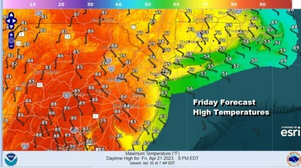
It will not be a screaming east wind but on the light side so that should allow many inland areas to rise into the 80s but this time around the highest temperatures will be in Southern Pennsylvania and points south into Maryland. 70s will be common in the Hudson Valley east of the Hudson River south to along the New Jersey coast. Points to the northeast in Southern New England will be in the upper 60s to lower 70s. There should be ample sunshine Friday.
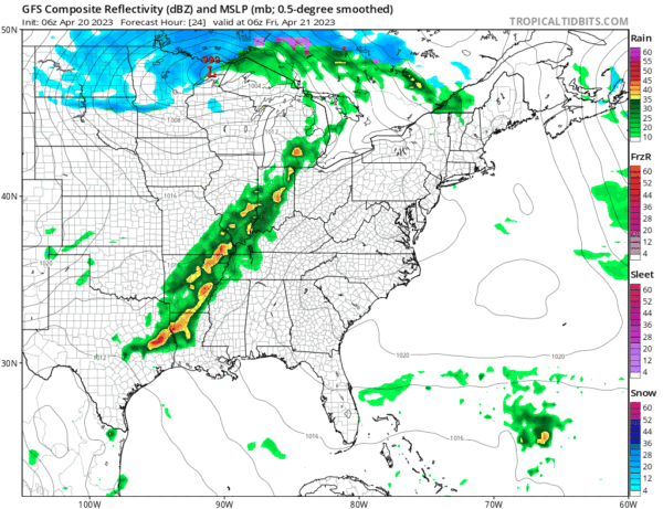
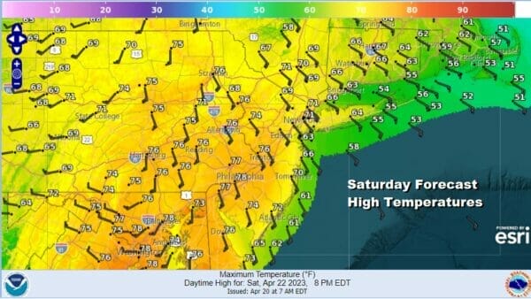
Let’s move on to the weekend. We have a cold front that will be approaching and it looks like it will keep on moving until it slows down offshore Sunday. Ahead of it Saturday we will have clouds and an increasing south wind so that will hold temperatures down somewhat. Wind speeds will be higher so that will keep inland temperatures down as well. Most highs Saturday will be in the 70s.
The cold front will bring showers and a few thunderstorms from west to east Saturday evening and into early Sunday morning. It looks to be a narrow line of showery rains but it may be enough to produce a half to three quarters of an inch of rainfall. The showers should be mostly gone by daybreak Sunday but the front slowing down offshore will likely keep cloud cover around Sunday. Showers may still linger in parts of Southern and Southeastern New England.
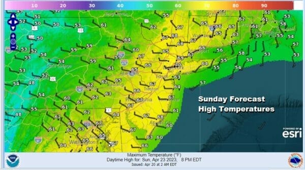
As to temperatures Sunday we will likely be mostly in the 60s but if you notice on the high temperature map mostly west winds until you reach the coast. Winds in much of Southern and Southeastern New England are from the south so this tells us that the front will be offshore but only barely. Weather conditions should improve though Sunday night into Monday and next week looks to be a cool week with perhaps some chances for rain late next week.
BE SURE TO DOWNLOAD THE FREE METEOROLOGIST JOE CIOFFI WEATHER APP &
ANGRY BEN’S FREE WEATHER APP “THE ANGRY WEATHERMAN!
MANY THANKS TO TROPICAL TIDBITS & F5 WEATHER FOR THE USE OF MAPS
Please note that with regards to any severe weather, tropical storms, or hurricanes, should a storm be threatening, please consult your local National Weather Service office or your local government officials about what action you should be taking to protect life and property.


