Ocean Wind Keeps It Cool Coast WarmHome Well Inland
Showers Thunderstorms Saturday Night

Ocean Wind Keeps It Cool Coast Warm Well Inland
Showers Thunderstorms Saturday Night
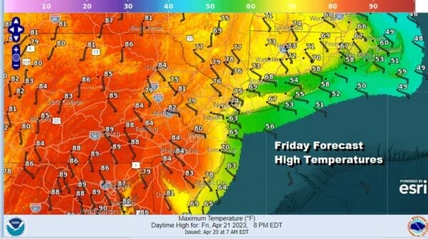
This is going to be a day of wide ranging temperatures from coast to inland areas. You can thank the east wind for this. This is not a strong onshore flow so we aren’t talking doom and gloom here. In fact it should be sunny for most if not all of the day especially inland. The wind will be light enough so that areas inland and west will reach into the 80s but strong enough near the coast to keep the Jersey Shore and South Coastal New England in the 60s. Radars are nice and quiet and there are no issues with rain today right through the daytime Saturday.
SATELLITE

WEATHER RADAR

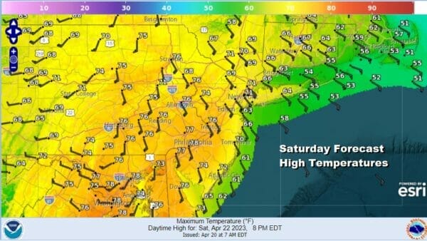
Tonight we will see some clouds develop as winds turn more southeast and eventually go south. Temperatures Saturday morning will be in the upper 40s to mid 50s. The dayside Saturday will be rain free but there will be clouds around. An increasing south wind both along the coast and inland will mean temperatures will be lower with highs just into the 70s in the warmest inland locations and 60s along the coast.
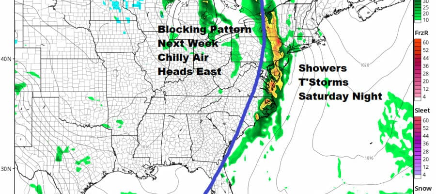
Saturday afternoon we will see a cold front beginning to move across Pennsylvania. Showers and thunderstorms will develop ahead of the front and they will start to move through from west to east Saturday evening and overnight. Most of the showers and thunderstorms will be done before daybreak Sunday but the front does slow down after it reaches the coast and that will likely keep showers going in parts of Southern, Southeastern New England and Long Island into Sunday morning.

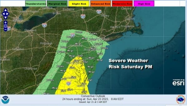
There is some risk for isolated severe thunderstorms with this cold front. The Storm Prediction Center indicates the risk will be from Central Pennsylvania to Central New Jersey and points southward but I think we could see this area nudged up a bit further north. This is not something that is going to become anything widespread but just allowing for the possibility for some stronger thunderstorms to develop ahead of the front.
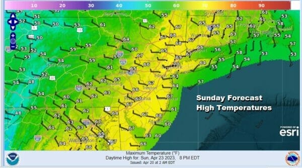
The weather front being so close offshore Sunday likely means that weather conditions will only improve very slowly. We certainly will see lots of leftover clouds Sunday and there is even the chance there could be a lingering shower. Sunday’s highs will be in the upper 50s well inland and low to mid 60s everywhere else.
Next week will be all about blocking across the US and Canada and that will lead us through a stretch of below average temperatures all next week. Right now with storm tracks further south, it would appear to be wet across much of the Southern US with lows tracking west to east but we may very well be dry until perhaps late next week as low pressure tries to make the turn up the East Coast but there is uncertainty about this right now. Blocking can also be too strong in which case systems will get suppressed to the south. Monday and Tuesday highs will be mostly in the 50s with some sunshine both days.
BE SURE TO DOWNLOAD THE FREE METEOROLOGIST JOE CIOFFI WEATHER APP &
ANGRY BEN’S FREE WEATHER APP “THE ANGRY WEATHERMAN!
MANY THANKS TO TROPICAL TIDBITS & F5 WEATHER FOR THE USE OF MAPS
Please note that with regards to any severe weather, tropical storms, or hurricanes, should a storm be threatening, please consult your local National Weather Service office or your local government officials about what action you should be taking to protect life and property.


