Warmer More Humid Conditions Week Ahead Severe Weather Risks Loom

Warmer More Humid Conditions Week Ahead Severe Weather Risks Loom

This Sunday is going to be the last day of reasonable humidity and it is on the rise. Dew points are rising but they will probably only reach the upper 50s to around 60 so it will feeling relatively comfortable. We will also see temperatures rise today as sunshine will take highs to the mid and upper 80s. We do have a weak upper trough that will be moving through tonight and that could set off an isolated shower or thunderstorm but I think for most of you, it will be rain free overnight. It will also be warmer than it has been in past nights and most lows Monday morning will be in the 60s. Radars during the dayside Sunday should be on the quiet side.
SATELLITE WITH LIGHTNING STRIKES

WEATHER RADAR

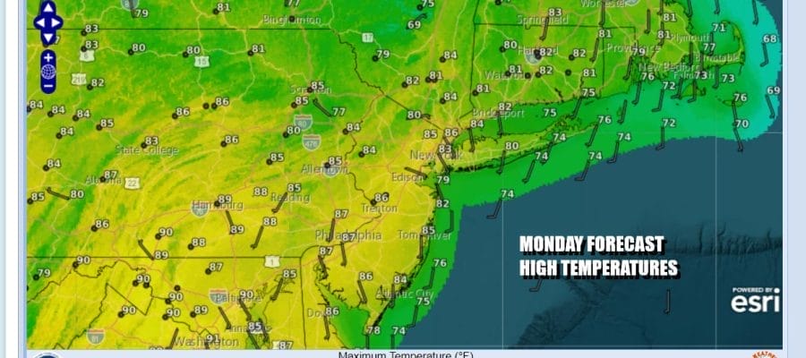
The work week begins and Monday sees very warm and very humid conditions. We have a cold front that will be approaching but it isn’t really much of a front. The upper trough with it is limited in what it can produce but we will see some sunshine head of this. Temperatures Monday will reach the mid to upper 80s. Dew points will be in the mid to upper 60s for the first time in a week so it will feel rather uncomfortable.

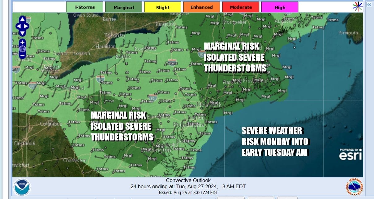
Late in the day Monday into Monday night there will probably be scattered showers and thunderstorms but we can’t rule out the possibility for an isolated severe thunderstorm or two so the Storm Prediction Center has a marginal risk for isolated severe thunderstorms from Northern New Jersey northeastward into Upstate NY and much of New England. A second area sets up from Southwest Pennsylvania into West Virginia and Northwestern Virginia and Western Maryland.
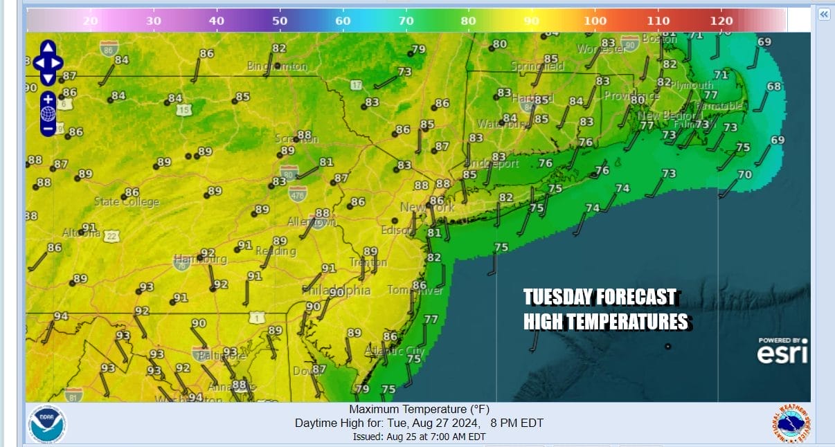
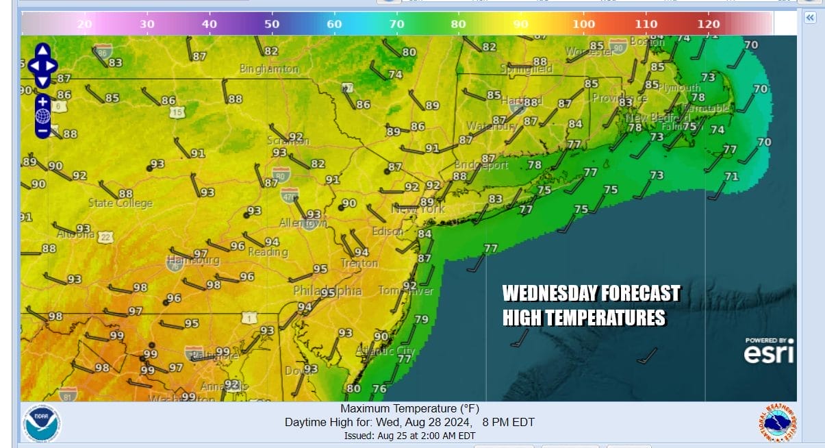
Tuesday and Wednesday we see temperatures rising further and dew points in the mid to upper 60s Tuesday and rising to 70 or higher Wednesday. Add to this is the fact that temperatures will be headed higher as well. Tuesday we see some sunshine. Highs will reach the upper 80s to some lower 90s in hot spots. Wednesday will be even hotter with highs reaching the upper 80s to lower 90s around New York City and nearby surrounding areas. Low to mid 90s will be common from Southern Pennsylvania and Southern New Jersey southward.
Another cold front will approach late Wednesday into Wednesday night and this front will bring more widespread shower and thunderstorm activity along with more widespread severe weather risk from Maine to Virginia. After this front passes high pressure builds into New England and we set up with an onshore flow Thursday and Friday. This will mean lower temperatures but the wind off the ocean will keep humidity levels on the high side. We will also likely have some cloud issues to deal with during nighttime and early morning hours especially along the coast. There will be enough sunshine to take temperatures into the 80s Thursday and Friday. No rain is forecast and it is possible that the start of the Labor Day holiday weekend will be dry.
BE SURE TO DOWNLOAD THE FREE METEOROLOGIST JOE CIOFFI WEATHER APP &
ANGRY BEN’S FREE WEATHER APP “THE ANGRY WEATHERMAN!
MANY THANKS TO TROPICAL TIDBITS FOR THE USE OF MAPS
Please note that with regards to any severe weather, tropical storms, or hurricanes, should a storm be threatening, please consult your local National Weather Service office or your local government officials about what action you should be taking to protect life and property.
(Amazon is an affilate of Meteorologist Joe Cioffi & earns commissions on sales.)


