Summer Weekend of Mostly Sunshine
Severe Weather Risk Monday As Humidity Rises

Summer Weekend of Mostly Sunshine
Severe Weather Risk Monday As Humidity Rises

The weekend which is the last weekend before the Labor Day holiday weekend (which is next weekend) is a reminder that summer is winding down so we should take advantage of the nice weather while we have it. This past week has been one of low humidity and cool temperatures. We will be slowly losing both of those this weekend but it will still be rather nice. Today is a day of lots of sunshine and high temperatures will reach into the lower 80s in most locations. Humidity levels are reasonable and should remain so today with dew points in the mid to upper 50s. No rain is forecast anywhere and radars are in silent mode.
SATELLITE WITH LIGHTNING STRIKES

WEATHER RADAR

We will continue with nice weather conditions overnight though some patchy fog could develop which is typical of the lengthening August nights. Lows will be in the upper 50s to mid 60s. Sunday we should see sunny skies for most of the day as high pressure is offshore and a weak upper trough approaches from the northwest. Highs Sunday will be in the low to mid 80s. Humidity levels will inch higher but still not unreasonable.

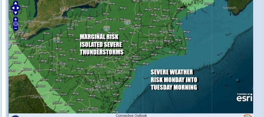
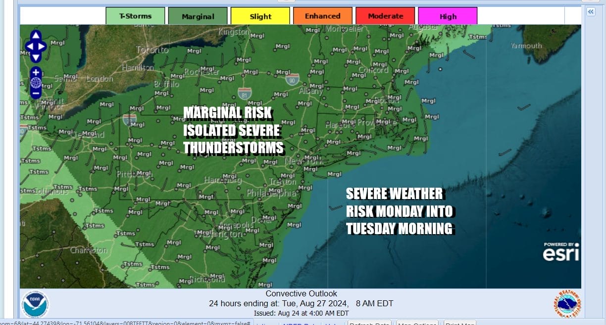
Sunday night into Monday a weak upper trough could set off an isolated shower or thunderstorm as we transition to a more humid air mass Monday. Then we have an approaching strong trough later Monday afternoon and this opens the door for thunderstorms and the risk for severe weather. The Storm Prediction Center indicates the risk for isolated severe thunderstorms over a large area extending from the Ohio Valley to the Mid Atlantic and Northeast.
Ahead of any thunderstorms it will be a very warm and humid day with cloudy to partly sunny skies. High temperatures will be in the mid to upper 80s and it will be uncomfortable with dew points rising to near 70. Late in the day showers and thunderstorms will be moving in and moving out. This is not the kind of set up that can result in serious widespread flash flooding like we saw at this time last weekend.

Much of next week will be very warm and humid with highs in the 80s. There will be some thunderstorm risk along the way. After Monday the next chance for showers and thunderstorms will be later Wednesday and Wednesday night and this could be another situation where we will be dealing with severe weather risk.
BE SURE TO DOWNLOAD THE FREE METEOROLOGIST JOE CIOFFI WEATHER APP &
ANGRY BEN’S FREE WEATHER APP “THE ANGRY WEATHERMAN!
MANY THANKS TO TROPICAL TIDBITS FOR THE USE OF MAPS
Please note that with regards to any severe weather, tropical storms, or hurricanes, should a storm be threatening, please consult your local National Weather Service office or your local government officials about what action you should be taking to protect life and property.
(Amazon is an affilate of Meteorologist Joe Cioffi & earns commissions on sales.)


