Warm Weekend Storm Threats Continue

We will be making the transition into a milder air mass this weekend but it is after this that we have 2 precipitation events to deal with. The first one comes Sunday night and Monday. We mentioned yesterday that there was a cheap thrill potential for this inland areas of Northeast Pennsylvania, Northwest New Jersey, the Hudson Valley and Connecticut mainly north of route 84 and we continue to believe this is the case based on the afternoon model runs. This is my early call snowfall forecast map for Sunday night Monday Morning.
Warm Weekend Storm Threats Continue
JOE’S SNOWFALL FORECAST SUNDAY NIGHT/MONDAY MORNING
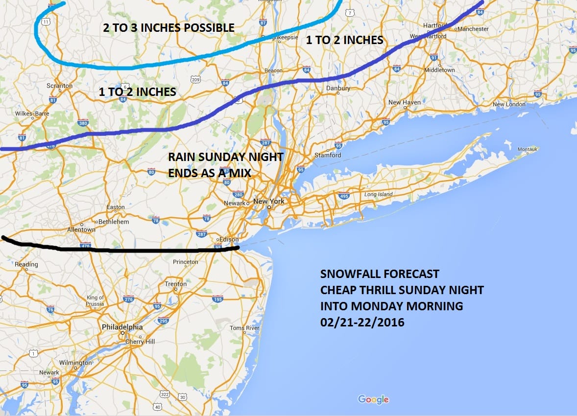
The European is actually is surprisingly aggressive with precipitation amounts Sunday night with .25 to .50 inches of liquid near the coast and showing .50 to .75 inches of rain in the area where I designated for 2 to 3 inches. The atmosphere is going to be borderline cold inland. I think there is a chance that it could go to a mix as you head south toward the coast before it ends Monday morning.
Warm Weekend Storm Threats Continue NAM MODEL SUNDAY NIGHT

The NAM model today only goes out to Sunday evening but there is a fairly decent area of precipitation and the European actually deepens the wave a little bit when it goes offshore to our south Monday morning. If the atmosphere was just a little bit colder and a little more dynamic, I might get a little nervous for a last minute surprise at the coast. But for now this is what I’m thinking.
Warm Weekend Storm Threats Continue European Model Monday Morning

With regards to the second storm for the middle of the week, The European has come in colder and decidedly less amplified on this run with an offshore track. This matches the GFS view and the ensemble means which have been showing an offshore track for days. We will address this storm with a JOESTRADAMUS post this evening.
OVERNIGHT GFS/EUROPEAN/CANADIAN VIDEO ANALYSIS
NATIONAL WEATHER SERVICE SNOW FORECASTS
LATEST JOESTRADAMUS ON THE LONG RANGE
Weather App

Winter is INSANE! With yet another threat for a coastal storm don’t be without Meteorologist Joe Cioffi’s weather app. It is really a meteorologist app because you get my forecasts and my analysis and not some automated computer generated forecast based on the GFS model. This is why your app forecast changes every 6 hours. It is model driven with no human input at all. It gives you an icon, a temperature and no insight whatsoever.
It is a complete weather app to suit your forecast needs. All the weather information you need is right on your phone. Android or I-phone, use it to keep track of all the latest weather information and forecasts. This weather app is also free of advertising so you don’t have to worry about security issues with your device. An accurate forecast and no worries that your device is being compromised.
Use it in conjunction with my website and my facebook and twitter and you have complete weather coverage of all the latest weather and the long range outlook. The website has been redone and upgraded. Its easy to use and everything is archived so you can see how well Joe does or doesn’t do when it comes to forecasts and outlooks.
Just click on the google play button or the apple store button on the sidebar for my app which is on My Weather Concierge. Download the app for free. Subscribe to my forecasts on an ad free environment for just 99 cents a month.
Get my forecasts in the palm of your hand for less than the cost of a cup of Joe!
![]()