Weather Models Continue Adjusting

Even though storm signals are continuing for the middle of next week, there still is a lot of uncertainty regarding how this all is going to play out. The European model today made a jump to a weaker look with the coastal low that is forecast for the East Coast. The GFS made a similar adjustment on its run. The Canadian on the other hand has been no where over the last number of days has jumped to a coast hugger look, right at the time the other models moved away from it.
Weather Models Continue Adjusting EUROPEAN GFS COMPARISON
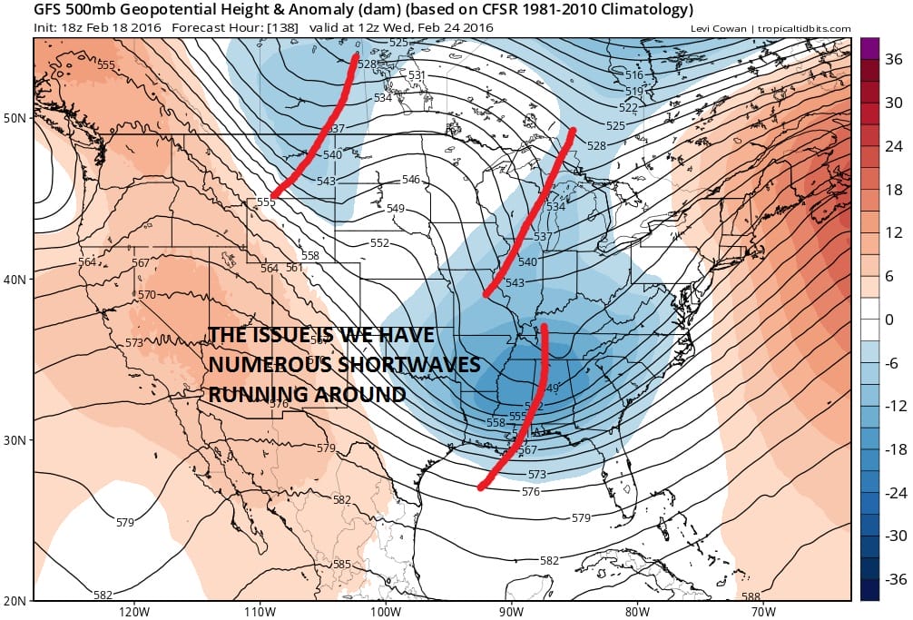
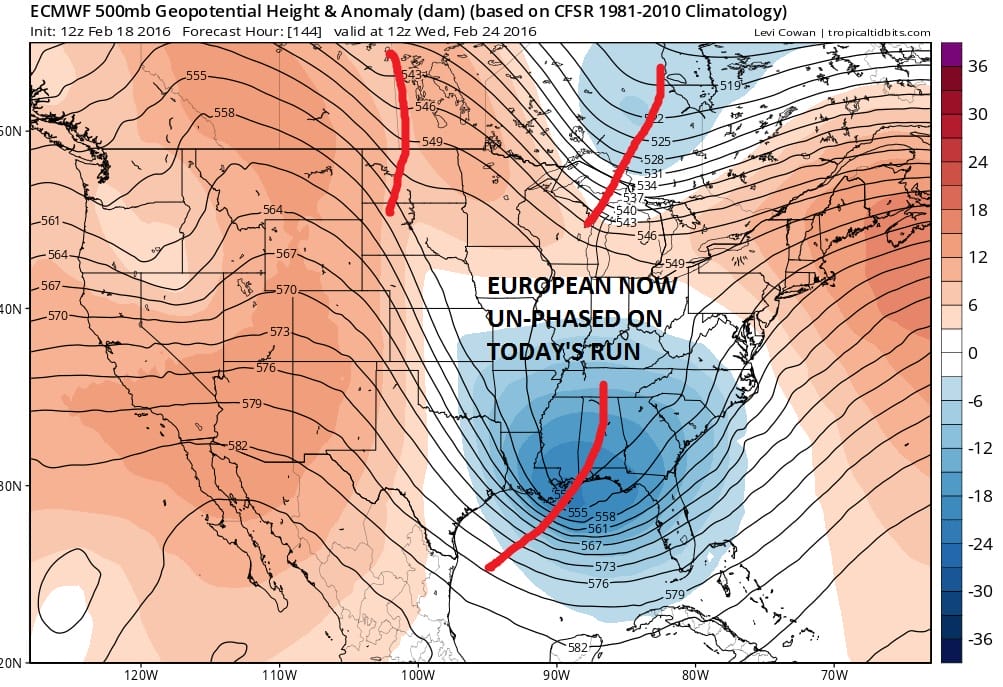
The problem is twofold. Firstly we have numerous shortwaves running around as evidenced on both models. This has been a signature of the entire winter season. Models seem to key on different shortwaves on every run. Sometimes they phase on some runs and we see deep lows. On other runs as short waves time out differently they don’t phase at all. The European on this run has moved away from the phased look and as a result has a coastal offshore track with a flatter look to it.
This does not mean that the current run is the correct solution because we are likely to see even more changes in subsequent runs. We could very well go to a more phased look. This would result in a deeper coastal low further to the west. I certainly can’t rule that out. I remember back in the days before the blizzard that the models lost it somewhat about 5 days for a couple of runs as it dealt with this very issue. Ultimately nothing was resolved from a practical forecast standpoint for our area until the last minute.
Weather Models Continue Adjusting GFS EUROPEAN SURFACE COMPARISON
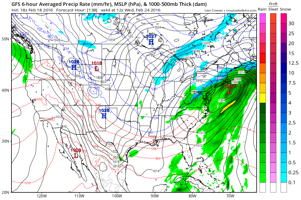
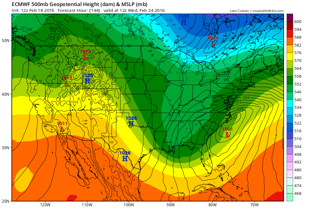
The surface maps on both models differ in the details with the European about 6 to 10 hours slower than the GFS. Another issue is cold air. We do not have a true arctic air mass setting up to the north. The cold air is marginal. However this winter in several events, we have seen cold air being a little more important. Will we see a repeat of that this time. The High to the north does move out from Quebec on both models so this is a concern. How models handle that will be another key to all this.
The bottom line is that we are still no closer to resolving the important issues regarding this event. We will just have to keep plugging away over the next several days until models settle on the phasing issue as well as which short waves are going to dominate. How the jet stream ultimately sets up will make big differences for some areas. All solutions remain on the table in my view including today’s.
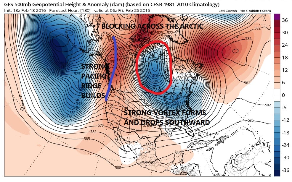
Longer term we see some very interesting developements. We have seen 2 major arctic warming events and both have led to quick shots of very cold air. We had one in the beginning of January and the other last weekend that caused records to fall. The GFS has been telegraphing another polar vortex to push southward. Now it should be noted that the European handles this differently so it remains to be seen how real this is
Weather Models Continue Adjusting LONG RANGE POLAR VORTEX INVASION NUMBER 3?
HERE IS THE OVERNIGHT VIDEO ANALYSIS OF THE GFS/EUROPEAN/CANADIAN MODELS
NATIONAL WEATHER SERVICE SNOW FORECASTS
LATEST JOESTRADAMUS ON THE LONG RANGE
Weather App

Winter is INSANE! With yet another threat for a coastal storm don’t be without Meteorologist Joe Cioffi’s weather app. It is really a meteorologist app because you get my forecasts and my analysis and not some automated computer generated forecast based on the GFS model. This is why your app forecast changes every 6 hours. It is model driven with no human input at all. It gives you an icon, a temperature and no insight whatsoever.
It is a complete weather app to suit your forecast needs. All the weather information you need is right on your phone. Android or I-phone, use it to keep track of all the latest weather information and forecasts. This weather app is also free of advertising so you don’t have to worry about security issues with your device. An accurate forecast and no worries that your device is being compromised.
Use it in conjunction with my website and my facebook and twitter and you have complete weather coverage of all the latest weather and the long range outlook. The website has been redone and upgraded. Its easy to use and everything is archived so you can see how well Joe does or doesn’t do when it comes to forecasts and outlooks.
Just click on the google play button or the apple store button on the sidebar for my app which is on My Weather Concierge. Download the app for free. Subscribe to my forecasts on an ad free environment for just 99 cents a month.
Get my forecasts in the palm of your hand for less than the cost of a cup of Joe!
![]()