Warm Rain Free Weekend Showers Arrive Monday Tuesday Cooler Late Next Week
WEATHER IN 5 PODCAST FRIDAY 9/25/2020
We are on the doorstep of the weekend and we continues deal with high pressure to the east and the remnants of Tropical Storm Beta to the south. High clouds will be an issue today south of NYC while it should be partly to mostly sunny today north and east of NYC. Temperatures today will be in the 70s to near 80 but temperatures will be lower as you go south. Areas in Maryland and Virginia for example will be in the lower 70s for highs and even 60s thanks to rain, while Southern New England could see highs over the 80 degree mark. Overall for most of you it will be a decent day.
SATELLITE

REGIONAL RADAR

Much like we saw yesterday there is rain from Southern Virgnina southward into the Carolinas and some of that rain is heavy but it is moving eastward and not lifting northward so this will not be an issue anywhere from Eastern Pennsylvania to Southern New England. In fact we have no rain in the forecast for this area through Sunday. Lows tonight will be in the upper 50s to mid 60s. Some clouds will develop overnight especially along the coast. Then they burn off to some sunshine. The same holds for Sunday. Highs Saturday will be in the 70s to near 80 and Sunday’s highs will be in the upper 70s to lower 80s.

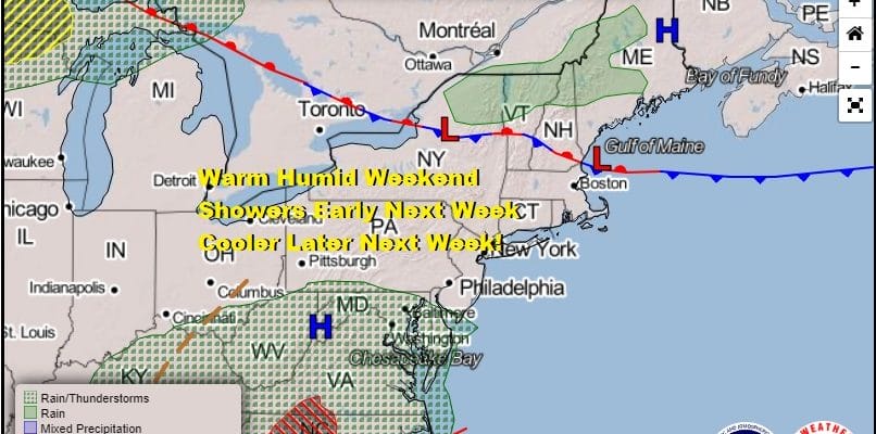
We haven’t seen much if any rain for the last 2 weeks and weather conditions are abnormally dry bordering on drought in parts of the Northeast especially New England. This should get some help early next week with an approaching cold front. Monday will bring some scattered showers but more numerous showers and possibly even a thunderstorm or two Tuesday into early Wednesday. Highs both Monday and Tuesday will be in the 70s. Much cooler air follows for the second half of the week and the long range suggests we could see cooler than average temperatures hanging around for awhile as October gets underway. The tropics are quiet and should remain so into next week but they cold rev up again in this overall favorable pattern for tropical storm development.
BE SURE TO DOWNLOAD THE FREE METEOROLOGIST JOE CIOFFI WEATHER APP &
ANGRY BEN’S FREE WEATHER APP “THE ANGRY WEATHERMAN!
MANY THANKS TO TROPICAL TIDBITS FOR THE USE OF MAPS
Please note that with regards to any severe weather, tropical storms, or hurricanes, should a storm be threatening, please consult your local National Weather Service office or your local government officials about what action you should be taking to protect life and property.


