DOWNLOAD MY NEW FREE JOESTRADAMUS WEATHER APP FOR ALL DEVICES
THE APP IS ABSOLUTELY FREE TO ALL BUT CONSIDERING SUBSCRIBING TO PATREON FOR A WEATHER EXPERIENCE FREE OF ADS, EXCLUSIVE VIDEOS FOR MEMBERS ONLY AND MUCH MORE…STARTS AT $2 A MONTH..MESSAGE ME AT ANY TIME
Warm Front Cold Front Combination Dry Saturday Chilly Rain Sunday
Two nice almost cloud free days in a row was a nice treat and now we move in the other direction. A warm front is beginning to set up to our south this morning across Virginia & the Delmarva Peninsula. We are also beginning to see high clouds stream in from the west and lying to the north of the frontal boundary. Gradually sunshine will fade away as the day wears on. This will impact temperatures today with highs in the 50s to near 60 along the coast and into the low and mid 60s inland. A wind off the ocean doesn’t help matters in the temperature department.
SATELLITE

REGIONAL RADAR

Regional radar shows showers in Southern Pennsylvania moving east and we are seeing some echos showing up in the local radars this morning. This precipitation is aloft and evaporating before it reaches the ground. We have lots of dry air around this morning and this should keep showers from popping up today.
LOCAL RADAR NEW YORK CITY

LOCAL RADAR PHILADELPHIA


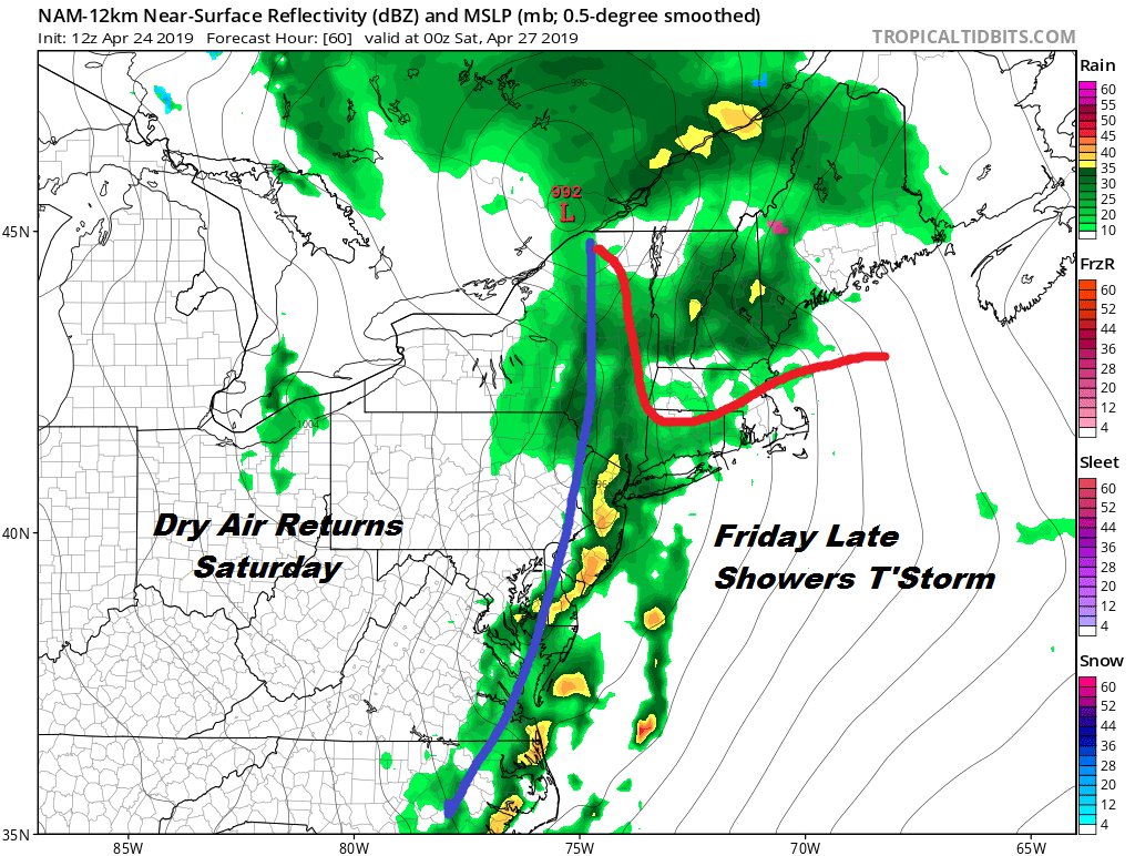
Late this afternoon into the evening a spot shower can’t be ruled out but we will see more numerous showers in the hours before and shortly after daybreak Friday. There could be some heavier downpours and perhaps even a thunderstorm as the warm front goes by. Once the warm front goes by we wait for the cold front that comes late in the day with more downpours and possible thunderstorms into Friday night. The Storm Prediction Center has placed Southern New Jersey and Southeastern Pennsylvania at a marginal risk for severe weather with the risk for general thunderstorms further north into the Hudson Valley and Southern New England. Temperatures on Friday will be in the 60s in most areas but Southern New Jersey south of Route 195 could see highs in the mid 70s to near 80.
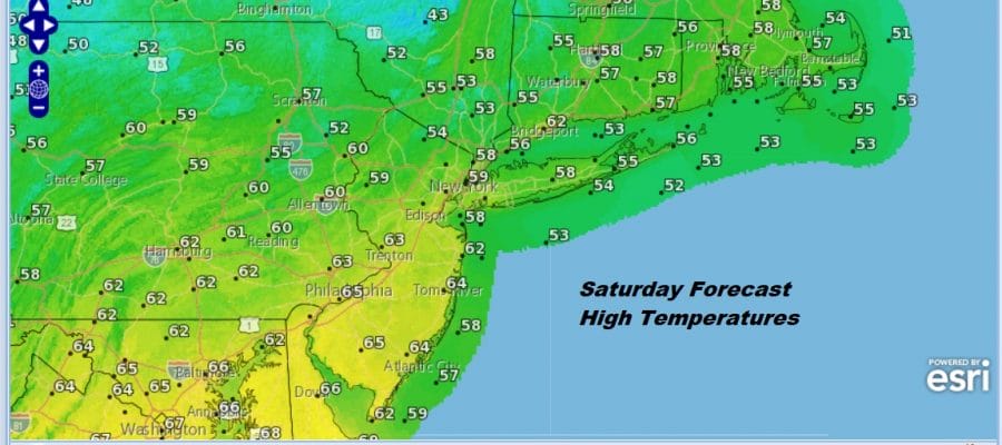
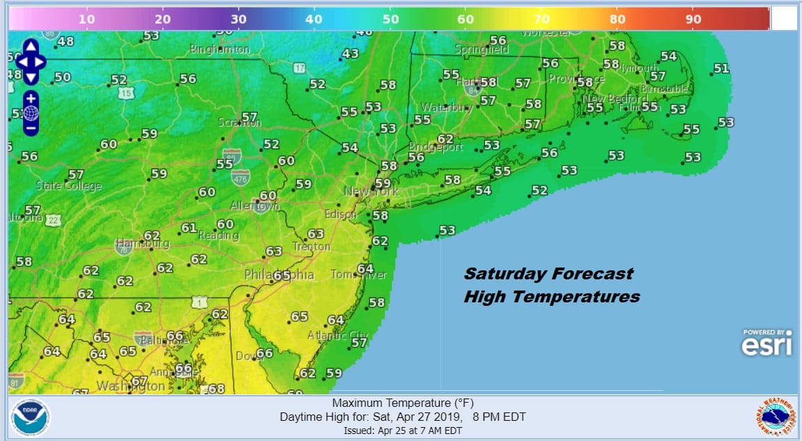
Now on to the weekend. These showers and thunderstorms will be over with before daybreak Saturday. Look for a mix of sun and clouds Saturday and winds will be strong and gusty from the northwest as low pressure strengthens in New England. Saturday will be rather chilly with highs just in the upper 50s to lower 60s in most places.
On to Sunday where we are going to be dealing with another weather system moving southeast from the Great Lakes and passing by to the south of NYC. Where the low goes will make a big difference in temperatures for Sunday. For example in the map below with a low center somewhere near Philadelphia and running right across Central New Jersey, if you are north of that track it will be a cloudy dreary day with some rain around and temperatures at best just into the 50s. For Connecticut, the Hudson Valley, Long Island and Northern New Jersey you would be sitting in this zone.

Just south of that front with that track and we are talking clouds with some breaks of sun and the risk for a passing shower. Highs in this zone (South Jersey & Southeast Pennsylvania) would be in the 60s. The low track will make or break all this. We will have to see how vigorous the Friday storm gets when it reaches New England as it will be suppressing the track of the follow up system on Sunday.
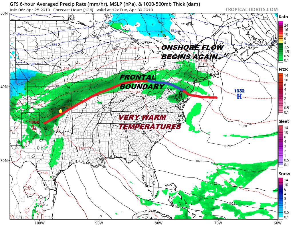
Monday looks like we squeeze in a dry decent day but here comes the next frontal boundary and onshore flow beginning Monday night and Tuesday which brings back clouds and the chance for showers. The game last week will be watching that frontal boundary go back and forth north and south which is going to mean forecast issues from day to day regarding clouds and showers. Very warm temperatures will like just to our south. Very cool temperatures lie to our north. We will be stuck somewhere in the middle.
MANY THANKS TO TROPICAL TIDBITS FOR THE USE OF MAPS
Please note that with regards to any tropical storms or hurricanes, should a storm be threatening, please consult your local National Weather Service office or your local government officials about what action you should be taking to protect life and property.


