Warm Front Brings Period of Snow Up to 2 Inches Inland
Week Ahead Brings Snow Ice Rain Risk Midweek

Warm Front Brings Period of Snow Up to 2 Inches Inland
Week Ahead Brings Snow Ice Rain Risk Midweek

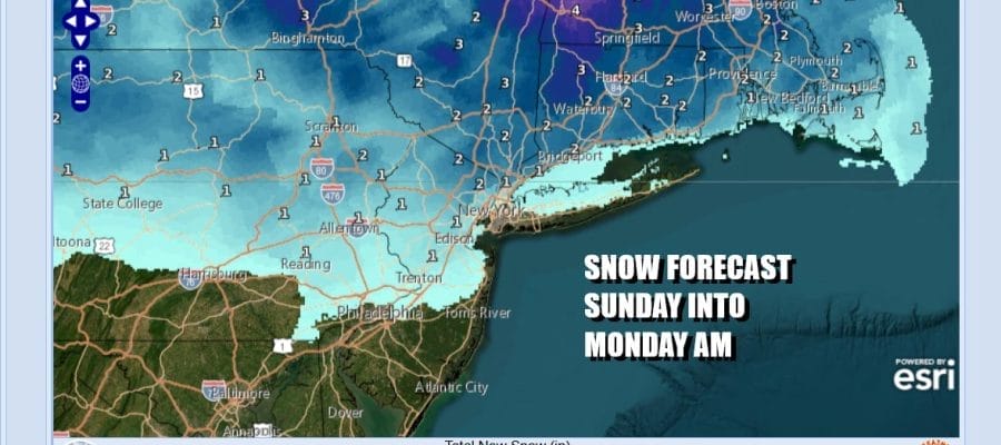
After a very cold start this morning as temperatures bottomed in the teens we will se sunshine ahead of arriving clouds. Inland highs will reach the upper 20s. Areas from NYC south should reach the 30s as clouds thicken up. A warm front is approaching as it heads east from the Great Lakes and heads into New England. That will set us up for a period of snow tonight with risk time window from 6pm to about 2am
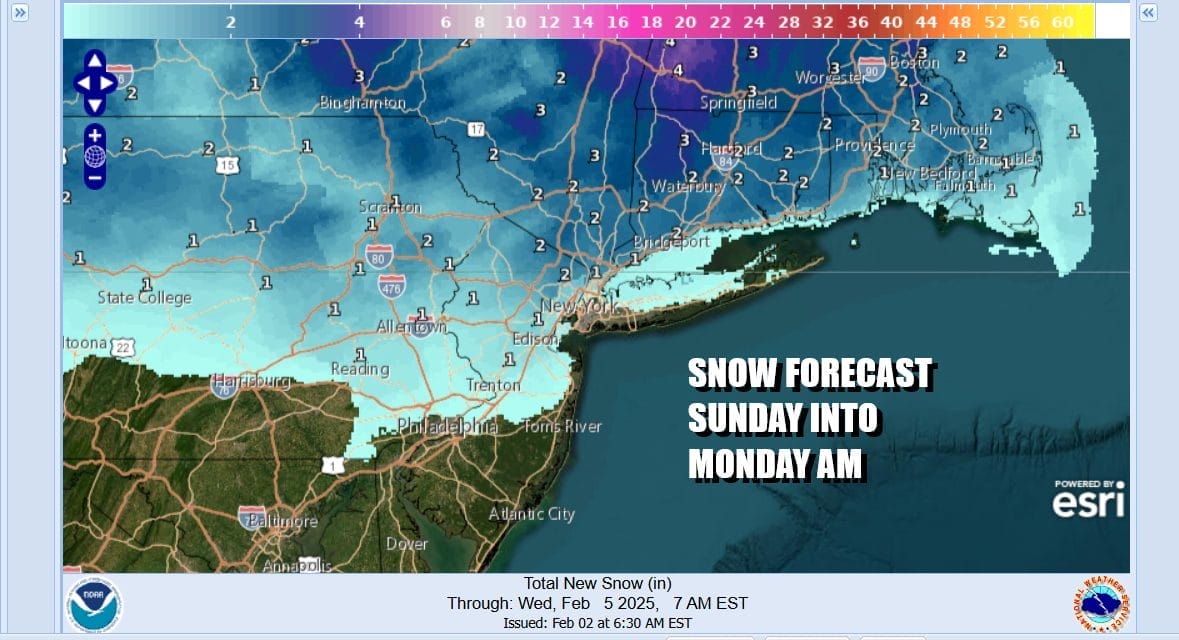
If you are south of Interstate 78 in New Jersey and Pennsylvania you won’t see much. Across Northeast Pennsylvania, Northern New Jersey north of Interstate 80 we are talking about an inch or perhaps 2 in some spots. The Hudson Valley and Connecticut could see up to 2 inches or a bit more in some places. Long Island could see a mix of rain and snow showers depending on temperatures and they sit on the edge of a coating.
SATELLITE WITH LIGHTNING STRIKES

WEATHER RADAR

Once the warm front passes we will see milder air and rising temperatures Monday. There is a cold front that will be coming through sometime Monday night so the dayside Monday will be dry with no worse than partly sunny skies. Most highs Monday will be in the upper 40s to lower 50s so obviously any snow that falls tonight will melt away quickly.
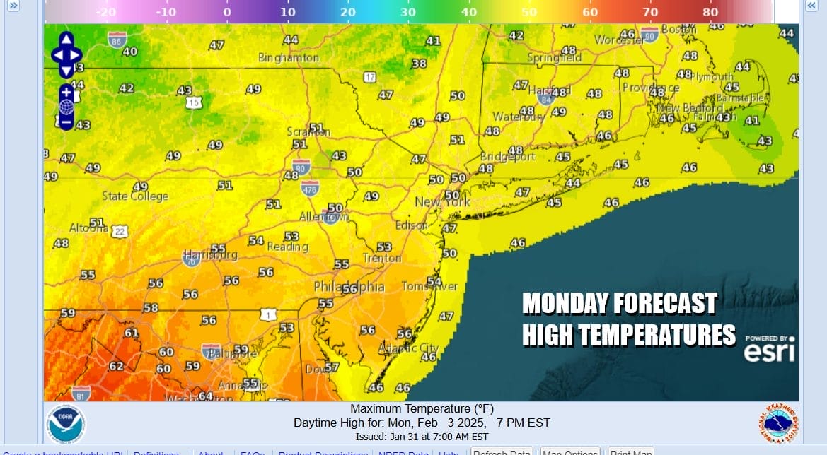
The cold front passes through Monday night with just clouds and the outside chance for a brief shower. Tuesday we will likely see the highs set early in the day as colder air gradually comes in. Sunshine will keep temperatures mostly in the 40s with the warmest spots in South Jersey and points south closer to 50.

We are heading into a busy weather pattern going forward which will be dominated by colder air spreading across the northern half of the US from east to west and an active southern half with weather systems getting ejected out every couple of days. The first of these systems will arrive later Wednesday into Thursday and it opens the door for a snow/ice/rain set up depending on your location.
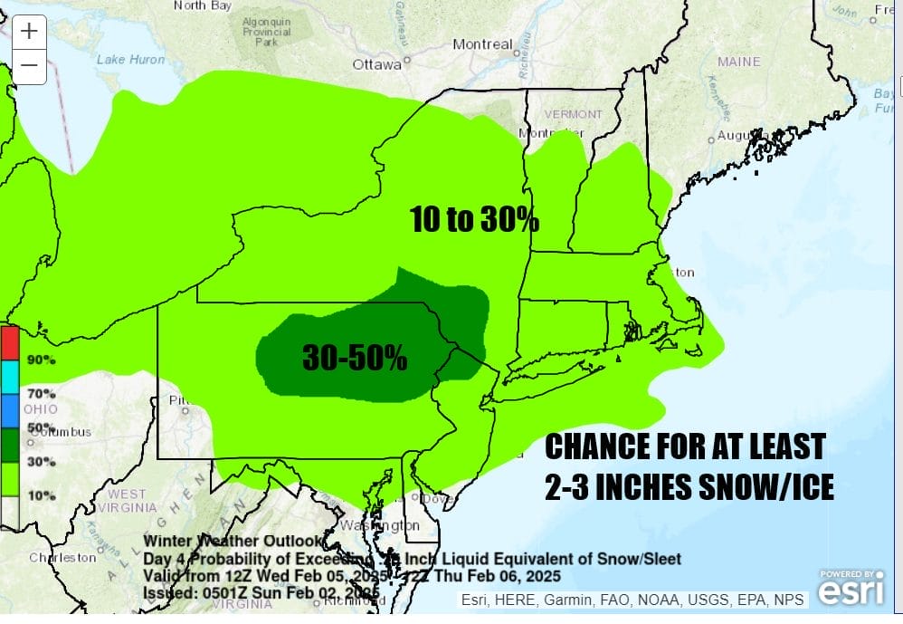
This system is in the long range portion of WPC’s forecast and we see much of the Northern Mid Atlantic, Upstate NY and most of New England in a 10 to 30 percent chance for at least 2 to 3 inches of snow and ice for late Wednesday into Thursday. Low pressure will be moving across the Ohio Valley and then offshore Thursday. How much cold air will wedge southward is a mystery at this point but this looks to be a colder set up than what we saw this past Friday. There will likely be several systems behind this one rolling through every 2 to 3 days over the next several weeks so it could prove to be an interesting stretch of weather going forward.
BE SURE TO DOWNLOAD THE FREE METEOROLOGIST JOE CIOFFI WEATHER APP &
ANGRY BEN’S FREE WEATHER APP “THE ANGRY WEATHERMAN!
MANY THANKS TO TROPICAL TIDBITS FOR THE USE OF MAPS
Please note that with regards to any severe weather, tropical storms, or hurricanes, should a storm be threatening, please consult your local National Weather Service office or your local government officials about what action you should be taking to protect life and property.