Very Warm Temperatures Severe Weather Risk Thursday
Memorial Day Weekend Severe Weather Risk Monday

Very Warm Temperatures Severe Weather Risk Thursday
Memorial Day Weekend Severe Weather Risk Monday
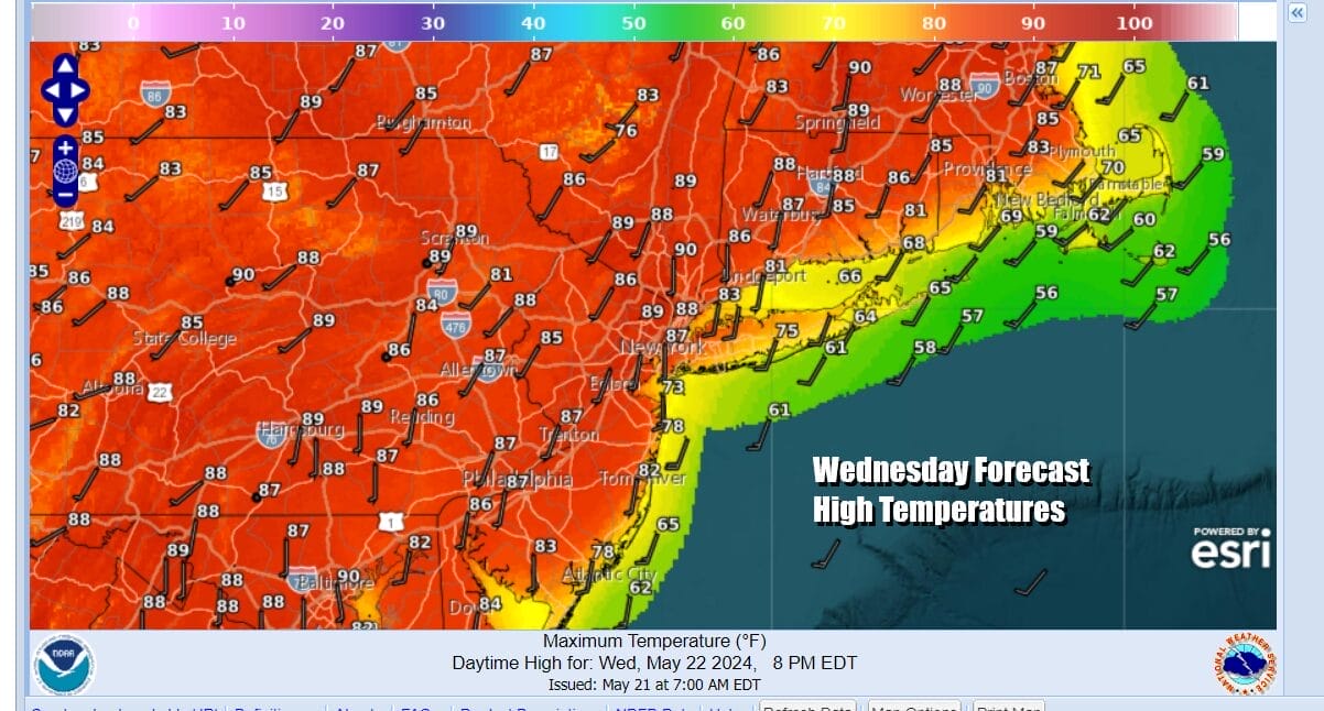
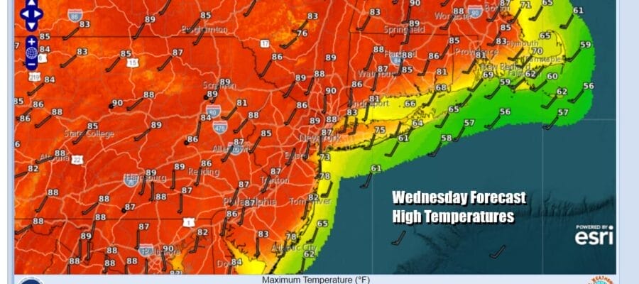
When a strong storm system tracks up into the Western Great Lakes it usually means warm weather in the Eastern US and we have certainly set ourselves up for this today. Yesterday we saw plenty of sunshine and temperatures that reached into the 80s away from the ocean. Today we have more of a southwest wind which lessens the impact of the cool ocean and most highs will be in the mid to upper 80s inland. This comes with plenty of sunshine for much of the day. Some warm spots could approach 90 degrees this afternoon.
SATELLITE WITH LIGHTNING STRIKES

WEATHER RADAR

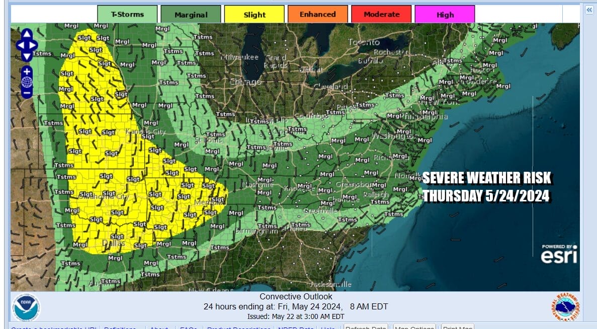
The Great Lakes storm system takes a turn east across Southern Canada and this brings about the risk for thunderstorms and severe weather. The Storm Prediction Center is indicating a marginal to slight risk for severe weather today and tonight across Western NY as well as much of Pennsylvania and into Northwest New Jersey but we think that risk for Eastern Pennsylvania and Northern New Jersey is more for the overnight rather than the dayside today.
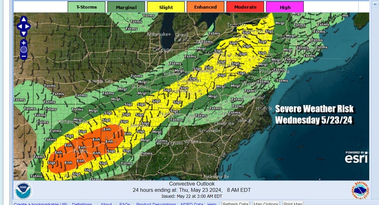
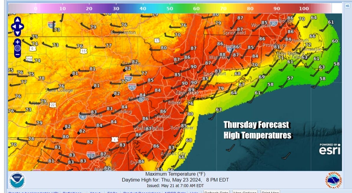
Thursday the risk area shifts eastward. The Storm Prediction Center is indicating a large area of marginal risk for severe weather from Maine southward to North Carolina and the westward into the Ohio Valley. Marginal risk means that any severe weather will be isolated as opposed to widespread. There will be showers and thunderstorm late Thursday as a cold front approaches and then ultimately passes off the coast.
Ahead of any thunderstorms Thursday, we should see sunshine and humidity levels will be edging higher. Temperatures will be in the mid to upper 80s for highs. Winds Thursday will be southwest and the south wind will be kept confined to areas right along the immediate coast. Normally this time of year thunderstorms tend to weaken as the near the coast because of the ocean influence. Thursday sees that influence minimized to some degree.
Heading into the Memorial Day holiday weekend we have some issues to contend with. This is the holiday weekend that comes in the spring and as a result tends to have more issues than the other summer holidays. Friday is getaway day and it looks to be dry and warm with some sunshine and highs in the 80s. Over the weekend, it should be dry much of the time but there is going to be some shower and thunderstorm risk.

Two risk periods to consider. One will be late Saturday into early Sunday morning. The second will be later in the day Monday as intensifying low pressure heads to the Eastern Great Lakes. In between those risk times it should be dry much of the time. If models are correct on this we could see some severe weather risks as the associated cold front approaches the coast later in the day. As for temperatures over the weekend we should be in the upper 70s to lower 80s Saturday and Sunday and 70s to near 80 Monday.
BE SURE TO DOWNLOAD THE FREE METEOROLOGIST JOE CIOFFI WEATHER APP &
ANGRY BEN’S FREE WEATHER APP “THE ANGRY WEATHERMAN!
MANY THANKS TO TROPICAL TIDBITS FOR THE USE OF MAPS
Please note that with regards to any severe weather, tropical storms, or hurricanes, should a storm be threatening, please consult your local National Weather Service office or your local government officials about what action you should be taking to protect life and property.
(Amazon is an affilate of Meteorologist Joe Cioffi & earns commissions on sales.)


