
Very Humid More Rounds of Rain, Drying Out Late Week & Weekend

Very Humid More Rounds of Rain, Drying Out Late Week & Weekend

The first round of rain moved through Eastern Pennsylvania to Southern New England with no major issues. It seemed the bulk of the heavier rain passed well inland and the area will continue to move along to the Northeast across New England and offshore. This leaves us in a day of leftover clouds giving way to partly sunny skies. It will remain very humid and most highs today will be in the low to mid 80s. We do not expect any showers or downpours during the dayside but we will likely see some showers and downpours tonight into Wednesday.

None of these waves moving along from the Southwest seem to be particularly problematic. The next round of showers and a few downpours will come later tonight into Wednesday morning. The rain doesn’t appear to be especially heavy and will be more of an inconvenience and not terribly problematic.
SATELLITE WITH LIGHTNING STRIKES

WEATHER RADAR

Temperatures Wednesday will be in the low to mid 80s for highs. Skies will be cloudy to partly sunny. Humidity levels will be high with dew points in the upper 60s to near 70. There is the chance we could see a downpour or a thunderstorm in the afternoon and evening but they should be scattered in nature.

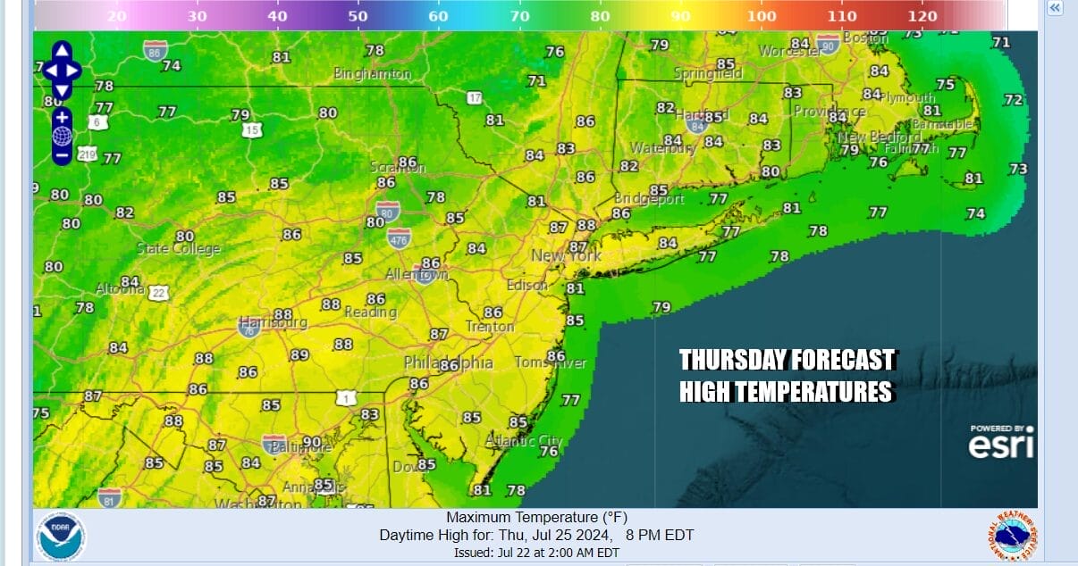
Thursday is the third and final wave and that comes with a cold front that will be moving east from the Great Lakes and passing offshore late Thursday night. Ahead of it we will be very warm and humid with cloudy to partly sunny conditions and the risk for some scattered showers or a thunderstorm. Severe weather risks remain low at this stage. Thursday highs will be in the 80s.
The cold front is forecast to keep on moving to the east and that will allow weak high pressure to build in for Friday and for the weekend. The air behind the front is just as warm as the air ahead of it so don’t expect much in the way of temperature change. We will see some dew point and humidity relief beginning Friday and probably lasting through the weekend.

We will see at least some sunshine all three days, Friday through Sunday with no rain in the forecast. Temperatures by day will be in the mid to upper 80s. Lows at night and during the early morning hours will generally be in the mid 60s to lower 70s. Next week it seems that we could see some hot weather moving in with highs beginning to break back into the 90s with humidity slowly climbing higher.
BE SURE TO DOWNLOAD THE FREE METEOROLOGIST JOE CIOFFI WEATHER APP &
ANGRY BEN’S FREE WEATHER APP “THE ANGRY WEATHERMAN!
MANY THANKS TO TROPICAL TIDBITS FOR THE USE OF MAPS
Please note that with regards to any severe weather, tropical storms, or hurricanes, should a storm be threatening, please consult your local National Weather Service office or your local government officials about what action you should be taking to protect life and property.
(Amazon is an affilate of Meteorologist Joe Cioffi & earns commissions on sales.)


