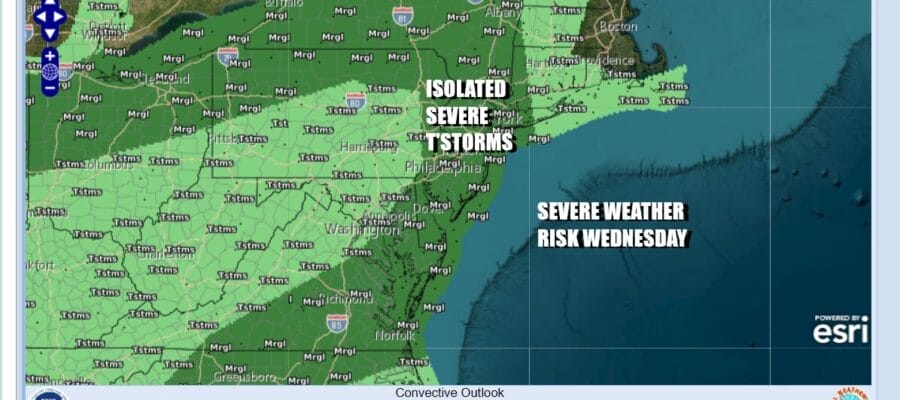
Isolated Severe Thunderstorms Possible Along With
Heavy Downpours Today Into Thursday

Isolated Severe Thunderstorms Possible Along With
Heavy Downpours Today Into Thursday
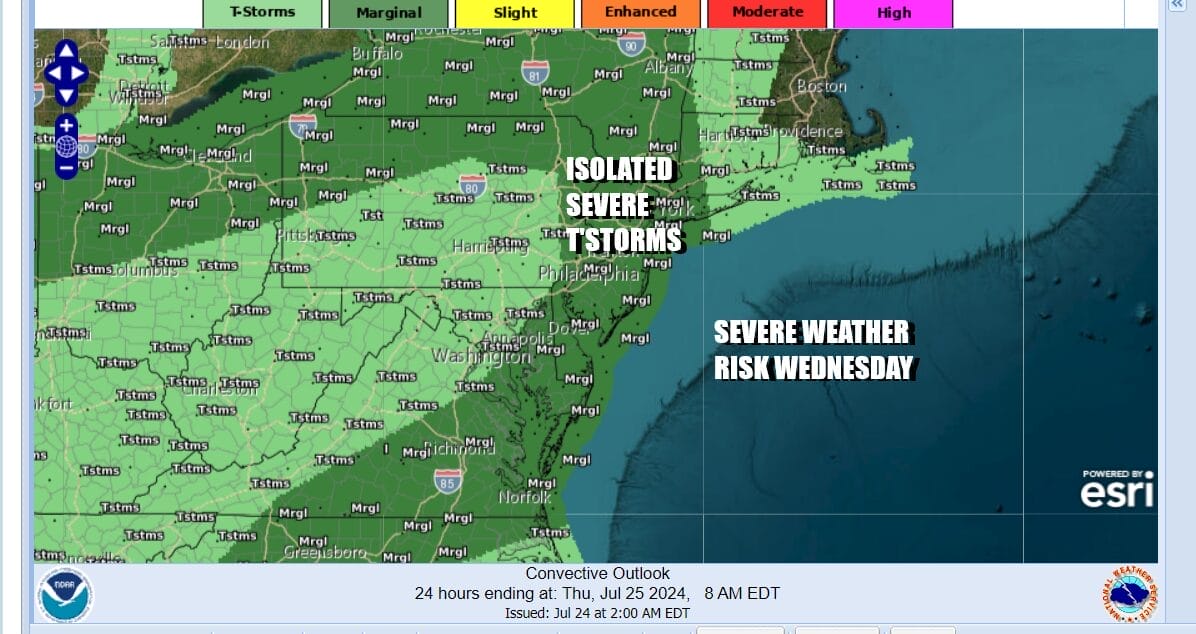
It is another case where it doesn’t rain all day but we will see some waves of downpours moving through today. Also we will mention that there is severe weather risk for much of Eastern Pennsylvania to Long Island and Western New England. The biggest risk is heavy rain and strong gusty winds as there will be isolated severe thunderstorms embedded in the flow.

We continue to be in a southwest flow of moist air from the Gulf States. Radars are showing patchy areas of rain moving northeast. When it is not raining it will be cloudy and very humid. Some sun might break through the clouds in some places. Temperatures today will top out mostly in the lower 80s depending on clouds and rain.
SATELLITE WITH LIGHTNING STRIKES

WEATHER RADAR

We expect to see the bands of rain around tonight into early Thursday. We do have a cold front that will be pushing east and that could perhaps set off some scattered thunderstorms and isolated severe thunderstorms during Thursday. Otherwise it will be another day of clouds and high humidity with highs in the low to mid 80s again depending on how much if any sun you receive.
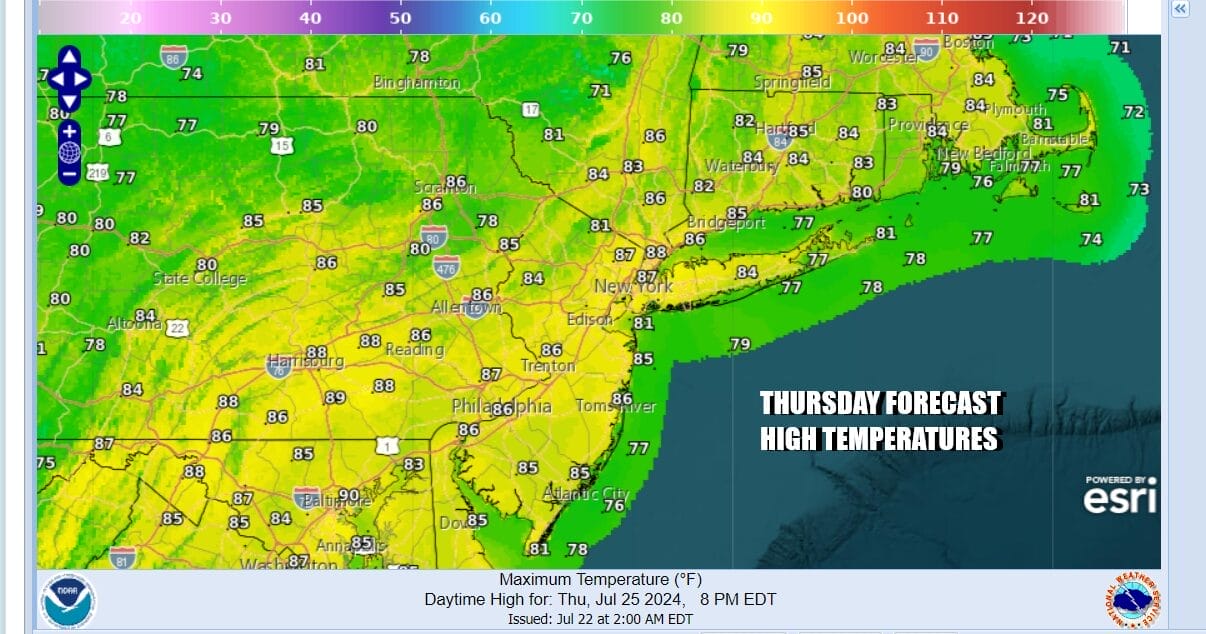
A cold front will pass through during Thursday evening and it will be followed by a lower humidity air mass from the Great Lakes. The air is drier behind the front but it is also warmer than the air ahead of it and this is due to the fact that once the high builds in, we will see considerable amounts of sunshine Friday right through Sunday. More sunshine means higher temperatures but at least the humidity will be lower as dew points drop into the 50s.
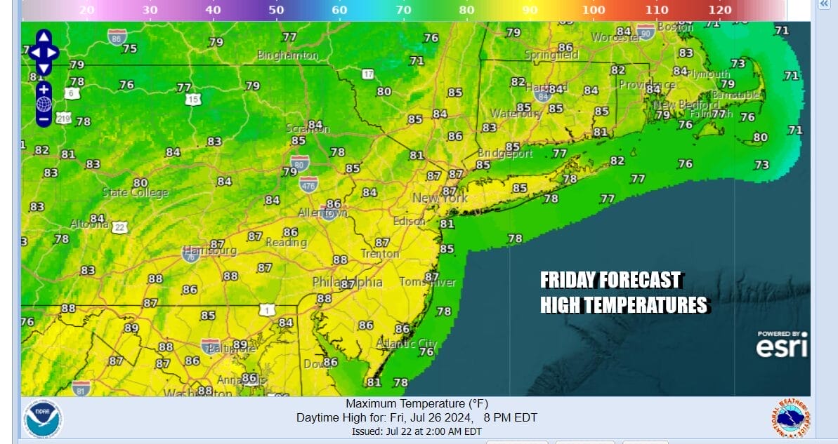

Both Friday and Saturday will be partly to mostly sunny with most high temperatures in the mid to upper 80s. Temperatures will be a little cooler at the shore with local sea breezes. Sunday we will see the core of the dry air mass slide offshore and it will be another day of sunshine. Highs Sunday will reach the mid 80s to near 90 degrees. No rain is forecast Friday right through the weekend.

Next week looks to be hot and more humid and there will probably be chances for afternoon and evening thunderstorms. There isn’t much of chance for storms Monday but we do see risks for thunderstorms Tuesday through Thursday. Highs each day will reach into the 90s. It appears that we may avoid getting into extreme heat which will centered more in the Plains from the Dakotas to Texas. Humidity levels will be going up as well though some dry air tries to hang on Monday.
BE SURE TO DOWNLOAD THE FREE METEOROLOGIST JOE CIOFFI WEATHER APP &
ANGRY BEN’S FREE WEATHER APP “THE ANGRY WEATHERMAN!
MANY THANKS TO TROPICAL TIDBITS FOR THE USE OF MAPS
Please note that with regards to any severe weather, tropical storms, or hurricanes, should a storm be threatening, please consult your local National Weather Service office or your local government officials about what action you should be taking to protect life and property.
(Amazon is an affilate of Meteorologist Joe Cioffi & earns commissions on sales.)


