Very Hot Highs in the Mid 90s Severe Weather Late Today Into Tonight

Very Hot Highs in the Mid 90s Severe Weather Late Today Into Tonight

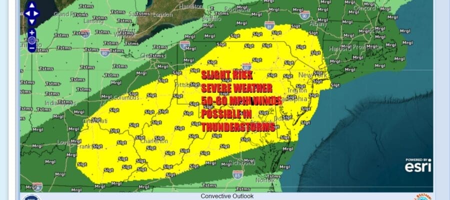
The next cold front is moving eastward through the Great Lakes and it is setting up Eastern Pennsylvania to Southern New England for late day and nighttime thunderstorms along with the potential for some of those thunderstorms to be severe. The Storm Prediction Center has expanded the slight risk zone to extend from Eastern Kentucky to New York State and the Hudson Valley south to New York City and Western Long Island. Marginal risk for severe weather extends into Southeastern New England.

Humidity levels are shooting up today as a warm front goes by to the north. Dew points will be rising to the upper 60s to around 70. Temperatures will be shooting up as well as highs reach the low and middle 90s in many areas. Look for sunshine into the afternoon before the cold front begins to get close. Right it appears that other than perhaps some renegade thunderstorms that pop up, the main area likely comes later in the evening and tonight.
SATELLITE WITH LIGHTNING STRIKES

WEATHER RADAR

Weather models seem to be in very good agreement as to how these storms play which is rather unusual. When it comes to convection you usually see different solutions and ultimately it becomes a game of watching the radar to see how things all play out. It appears that a lead squall moves across Eastern Pennsylvania later in the evening. Storms are forecast to reach the New Jersey coast and Western Long Island around 9 or 10 pm.

The biggest risk from these thunderstorms appears to be straight line wind and gusts of 50 to 60 mph are possible as the lead squall line moves through. There will be a second band of downpours and perhaps a thunderstorm or two behind the first squall line and that will move offshore during the early morning hours Thursday between 2 and 6am.
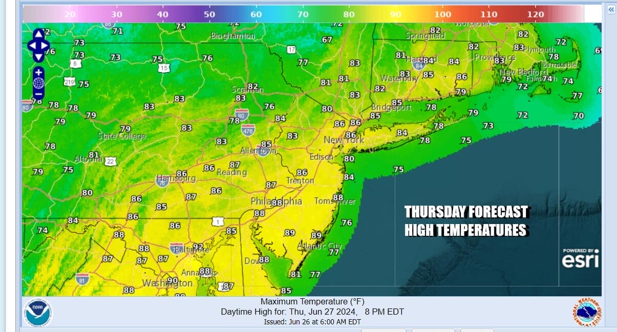
We are going to see improving weather conditions Thursday as highs will be generally in the 80s. We will see some sunshine and a bit of gusty breeze. Another upper trough will move through with a very narrow line of showers mainly in New England so a very brief shower or thunderstorm can’t be ruled out east of NYC. Friday we will see lower humidity and sunshine and highs will be mostly in the lower 80s.

The up and down pattern continues over the weekend as cold fronts move through every 2 to 3 days. The next one after today looks to time out for late Saturday. Look for Very warm and more humid conditions Saturday with highs reaching the mid to upper 80s. Showers and thunderstorms will likely come in from west to east during the afternoon and evening and there could be some lingering showers around Sunday until the cold front makes a final pass offshore.
BE SURE TO DOWNLOAD THE FREE METEOROLOGIST JOE CIOFFI WEATHER APP &
ANGRY BEN’S FREE WEATHER APP “THE ANGRY WEATHERMAN!
MANY THANKS TO TROPICAL TIDBITS FOR THE USE OF MAPS
Please note that with regards to any severe weather, tropical storms, or hurricanes, should a storm be threatening, please consult your local National Weather Service office or your local government officials about what action you should be taking to protect life and property.
(Amazon is an affilate of Meteorologist Joe Cioffi & earns commissions on sales.)


