Heat Returns Severe Weather Risk Late Wednesday As Cold Front Arrives
Less Humid Late Week

Heat Returns Severe Weather Risk Late Wednesday As Cold Front Arrives
Less Humid Late Week
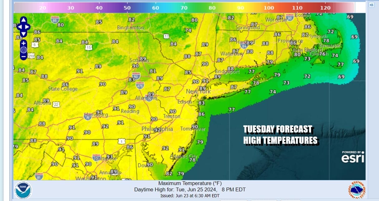
We have dry air still hanging over the Northeast and Northern Mid Atlantic states. Today looks to be a day of sunshine and temperatures are going to be on the hot side as highs reach the upper 80s and lower 90s. However as they say in Arizona, it is a dry heat as dew points will be in the 50s all day long. This makes it reasonably comfortable for most folks today. No showers or thunderstorms are forecast today as the radars are nice and quiet. We will see some changes Wednesday.
SATELLITE WITH LIGHTNING STRIKES

WEATHER RADAR

Humidity levels will be rising tonight as dew points rise and temperatures hold in the mid 60s to lower 70s. Wednesday is going to be a very hot and humid day with dew points near 70 and highs in many areas reaching the middle 90s. This is going to make things rather oppressive. We will also have a very unstable air mass developing and with all the daytime heating the risk for thunderstorms will rise as we move through the day.

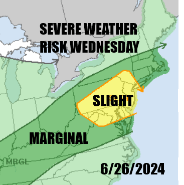
An approaching cold front will likely set off heavy downpours and thunderstorms and the Storm Prediction Center is indicating an expanded area of risk. We also see an elevated risk for an isolated tornado or two. Thunderstorms are likely to develop during the mid to late afternoon in Eastern Pennsylvania to Southern New England. Winds off the ocean could temper storms somewhat east of New York City.

The front is going to pass during the overnight so the risk for downpours and thunderstorms could last into the early morning hours especially along the coast but ultimately it will be long gone by daybreak. Thursday sees improving weather conditions with lower temperatures and lower humidity. Some sunshine returns and highs will be in the low to mid 80s.

Friday is likely to be a repeat performance with sunshine and low humidity and highs mostly in the low to middle 80s. The pattern will continue to see cold fronts come through with shower and thunderstorm risk. We will warm up ahead of the front and have a day or two of heat and cool down behind the front for a day or two. Another front is likely to arrive late Saturday splitting the weekend in two. Saturday looks very warm and humid. Sunday looks warm and less humid with thunderstorm risk late Saturday and Saturday night.
BE SURE TO DOWNLOAD THE FREE METEOROLOGIST JOE CIOFFI WEATHER APP &
ANGRY BEN’S FREE WEATHER APP “THE ANGRY WEATHERMAN!
MANY THANKS TO TROPICAL TIDBITS FOR THE USE OF MAPS
Please note that with regards to any severe weather, tropical storms, or hurricanes, should a storm be threatening, please consult your local National Weather Service office or your local government officials about what action you should be taking to protect life and property.
(Amazon is an affilate of Meteorologist Joe Cioffi & earns commissions on sales.)


