Heatwave Broken Lower Humidity Into Tuesday
Showers Thunderstorms Late Wednesday

Heatwave Broken Lower Humidity Into Tuesday
Showers Thunderstorms Late Wednesday
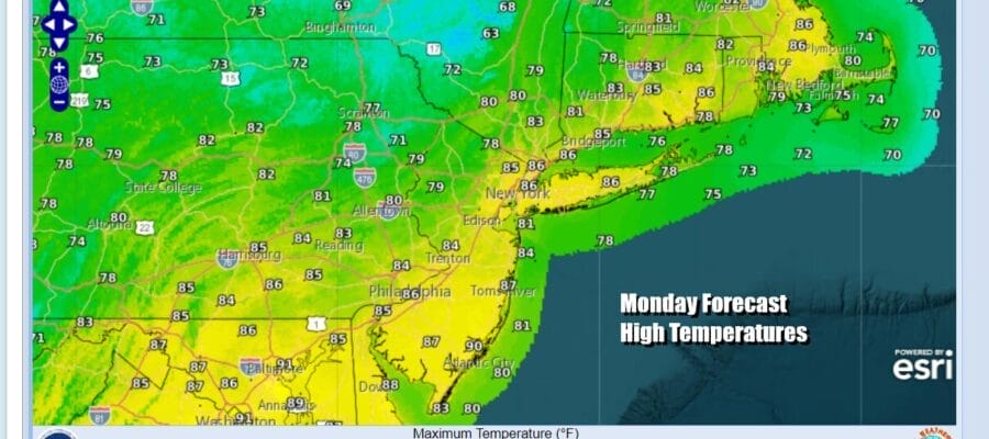
The heatwave has come to an end and we going to see a break in the extreme temperatures however it is a short break. Last night’s cold front has now passed through and behind that front we have a slightly cooler air mass with lower humidity. You will feel the difference today as dew points drop into the 50s. We will see sunshine and highs reaching the 80s ranging from near 80 in the Lower Hudson Valley and points north to low and middle 80s Southern Pennsylvania and Southern New Jersey. Radars are nice and quiet and we see no shower or thunderstorm issues for the next couple of days.
SATELLITE WITH LIGHTNING STRIKES

WEATHER RADAR

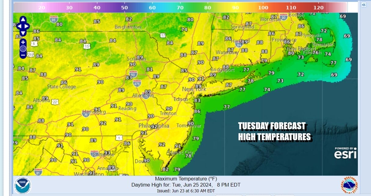
Hot temperatures will be coming back Tuesday but humidity levels will still be reasonable as dew points hold in the 50s. Yes it will be hot with highs back into the lower 90s in many inland spots but the reasonable humidity will make it bearable.
Oppressive heat and humidity will be back Wednesday as southwest winds bring up humid air and temperatures take off even higher. Sunshine will take highs up to the middle 90s in many locations and a few upper 90s can’t be ruled out. Dew points will be rising back to the upper 60s and lower 70s creating very uncomfortable conditions. Late in the day and into the evening we will see showers and thunderstorms develop and move through from west to east.

We have another cold front and another strong short wave trough moving through the Great Lakes. The atmosphere will be very unstable across much of the Northeast and Mid Atlantic states and the high dew points will combine to produce late day and evening thunderstorms. We also see severe weather risk and the early forecast from the Storm Prediction Center indicates a slight risk of 15 percent from Northern West Virginia and Southwest Pennsylvania northeastward into the Catskills & Hudson Valley in New York, extending into Northwest New Jersey.
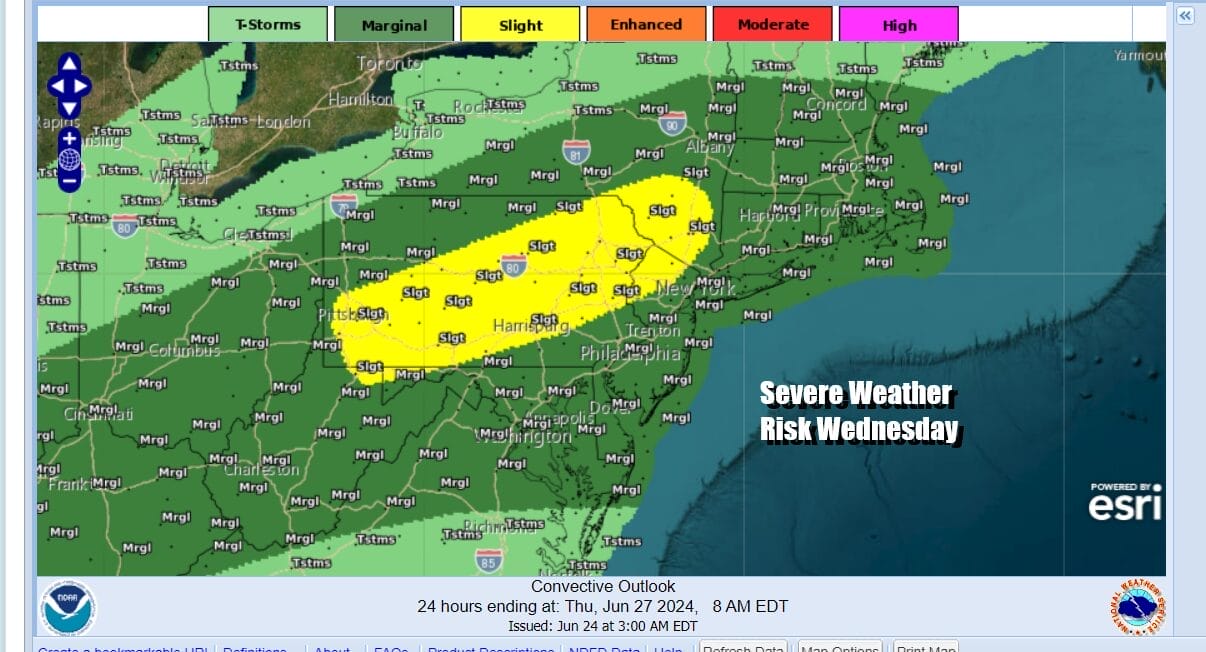
Marginal risk for isolated severe thunderstorms extends from the Ohio Valley all the way to Southeastern New England. There is the possibility that the Storm Prediction Center will expand the slight risk zone and introduce elevated tornado risk for Wednesday given the dynamics in play. This front will be another one that moves along so weather conditions will improve for Thursday and Friday

We see another “cooler” drier air mass that will lower temperatures back to where they should be for this time of year and more importantly we will see dew points drop down to comfortable levels. Thursday and Friday highs will be in the 80s and there should be a fair amount of sunshine both days. Then we go through the same thing again Saturday and Sunday where heat and humidity return followed a cold front, thunderstorm and severe weather risk Sunday.
BE SURE TO DOWNLOAD THE FREE METEOROLOGIST JOE CIOFFI WEATHER APP &
ANGRY BEN’S FREE WEATHER APP “THE ANGRY WEATHERMAN!
MANY THANKS TO TROPICAL TIDBITS FOR THE USE OF MAPS
Please note that with regards to any severe weather, tropical storms, or hurricanes, should a storm be threatening, please consult your local National Weather Service office or your local government officials about what action you should be taking to protect life and property.
(Amazon is an affilate of Meteorologist Joe Cioffi & earns commissions on sales.)


