Brutal Sunday of Extreme Heat High Humidity Severe Weather & Tornado Risks

Brutal Sunday of Extreme Heat High Humidity Severe Weather & Tornado Risks

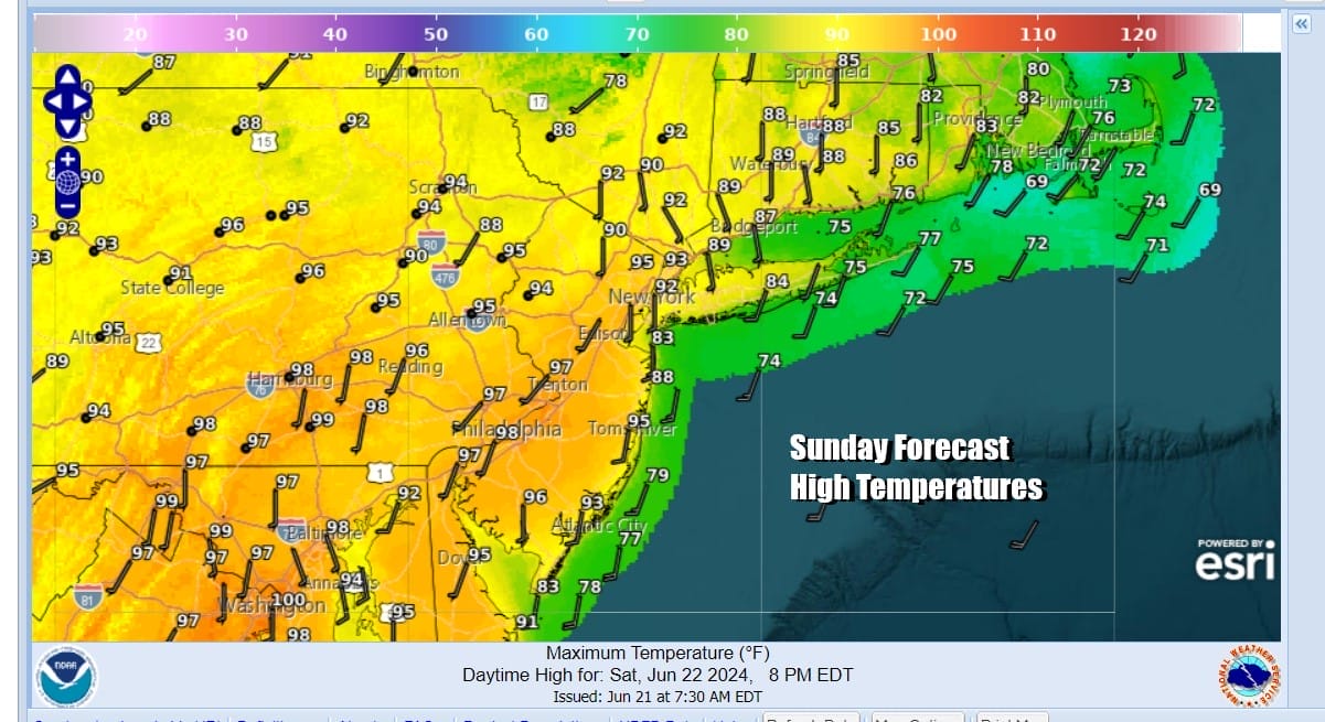
This is not going to be a fun Sunday. We will start off with the brutal heat and humidity. Heat advisories are posted as well as Excessive Heat Warnings for parts of Eastern Pennsylvania and New Jersey. This is going to be a very hot and humid day as sunshine will take highs to 95 to near 100 degrees from New York City south and west. Temperatures might be a little lower over Southern New England and Long Island but it will still reach the 90s.

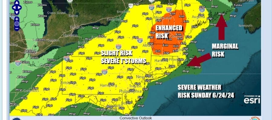
This will be the last day of the current heatwave as we have a strong cold front and upper trough approaching from the Great Lakes and Ohio Valley. The satellite loop signature indicates a strong upper trough is swinging through the Great Lakes. Add that to the massive daytime heating and a very unstable atmosphere and you have the makings for a widespread severe weather risk zone from Virginia to Maine and even an enhanced risk for severe weather being indicated for parts of Central and Northwest New England.
SATELLITE WITH LIGHTNING STRIKES

WEATHER RADAR

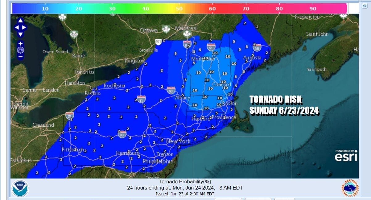
Elevated tornado risk happens from time to time in the Northeast and Mid Atlantic and we have that for late today and tonight. It isn’t often that we see 5 percent and 10 percent is somewhat rare. Today we have both and it is concentrated in New England. However the 2 percent tornado risk zone extends from Maine south to Virginia.
Timing of thunderstorms is tricky. We could see some renegade thunderstorms pop up early this afternoon anywhere in this zone before we see clusters of thunderstorms develop as well as possible northeast to southwest squall lines. The greatest risk for much of Eastern Pennsylvania to Southern New England will be from 2pm to midnight and for most, the 4pm to 8pm time frame will be most critical.
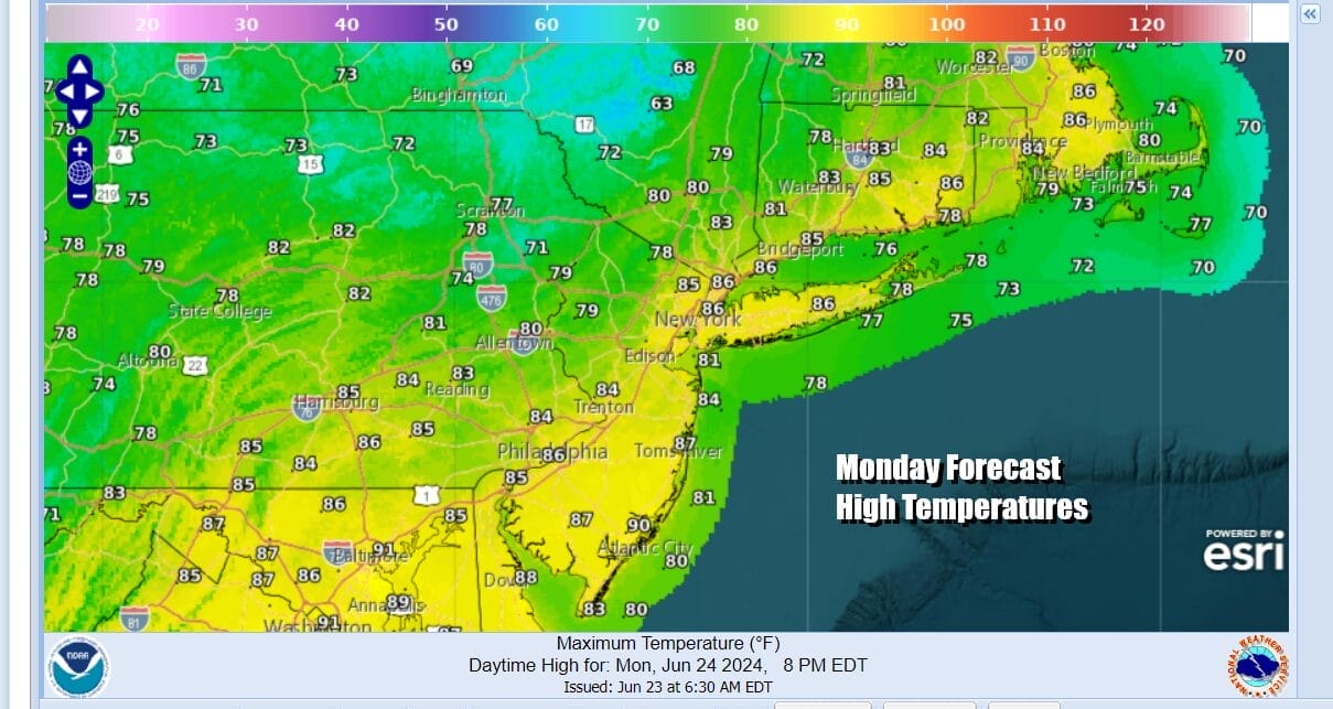
Once the front moves offshore late tonight lingering clouds and showers will end . There might be a few lingering clouds around Monday morning and perhaps a leftover shower. Overall it will be a day of clouds giving way to some sunshine. Temperatures will be noticeably cooler and humidity levels will come down. Most highs Monday will be in the low to mid 80s. Some areas north of NYC might not get out of the 70s.
Temperatures will rise a little Tuesday to the mid 80s to near 90 degrees in most places. It will be a sunny day and the humidity will still be reasonable. However that goes away Wednesday and Thursday. We will see those two days producing temperatures in the low to middle 90s with high humidity. Thursday brings another cold front and another risk for thunderstorms and severe weather.
BE SURE TO DOWNLOAD THE FREE METEOROLOGIST JOE CIOFFI WEATHER APP &
ANGRY BEN’S FREE WEATHER APP “THE ANGRY WEATHERMAN!
MANY THANKS TO TROPICAL TIDBITS FOR THE USE OF MAPS
Please note that with regards to any severe weather, tropical storms, or hurricanes, should a storm be threatening, please consult your local National Weather Service office or your local government officials about what action you should be taking to protect life and property.
(Amazon is an affilate of Meteorologist Joe Cioffi & earns commissions on sales.)


