Heatwave Continues into Sunday
Severe Weather Risk & Tornado Risk Elevated Inland

Heatwave Continues into Sunday
Severe Weather Risk & Tornado Risk Elevated Inland

We have another hot day ahead but we also have a weak frontal boundary stalled out over the Hudson Valley and into Southeastern New England. South of the front it will be another hot and humid day especially west of New York City. Highs will reach the middle and upper 90s for the second day in a row from Northern New Jersey south and west into Eastern Pennsylvania to Delaware and Maryland. Heat advisories are up for much of this area.
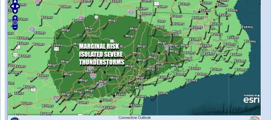
The frontal boundary being close by sets up another round of afternoon and evening thunderstorms and some of those thunderstorms could be strong or severe. The Storm Prediction Center is indicating an marginal risk for severe weather from Eastern Pennsylvania into Southwestern New England which includes the Hudson Valley, the Catskills, New York City and Northern New Jersey. General thunderstorms are forecast elsewhere. We saw thunderstorms yesterday in Southern and Southeastern New England producing some areas of flash flooding and the slow movement of these storms could create localized flash flooding. It should also be noted that not everyone will see thunderstorms and it should be mostly dry into the early and mid afternoon.
SATELLITE WITH LIGHTNING STRIKES

WEATHER RADAR

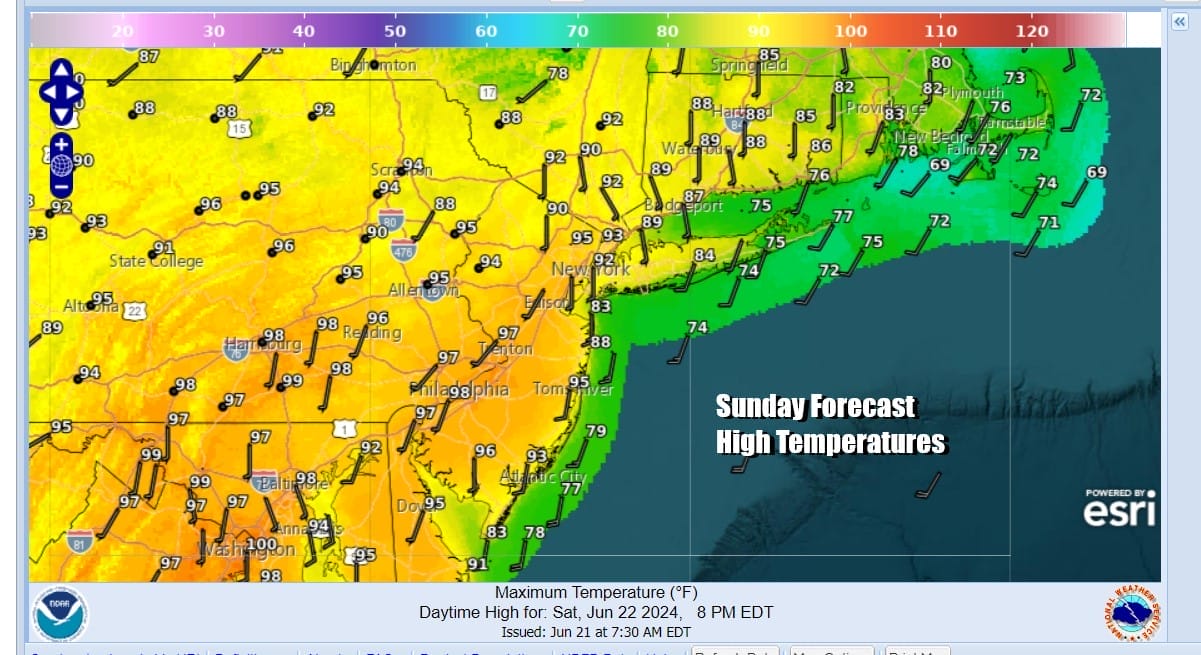
Once these thunderstorms are done we are left with very warm and very humid conditions overnight. Most lows Sunday morning will be in the 70s to around 80 degrees.. Sunday sets up as a brutal day with excessive heat and high humidity. Sunshine into the afternoon will take temperatures into the mid to upper 90s. We saw Newark New Jersey hit 100 degrees Friday and it would not surprise me if we saw 100 degree highs in parts in New Jersey (away from the ocean) as well as parts of Eastern and Southeastern Pennsylvania. New York City saw upper 90s Friday and we will see middle to upper 90s. It will be a little cooler to the east on Long Island and in Southern New England but highs will reach 90 degrees or higher away from the ocean.
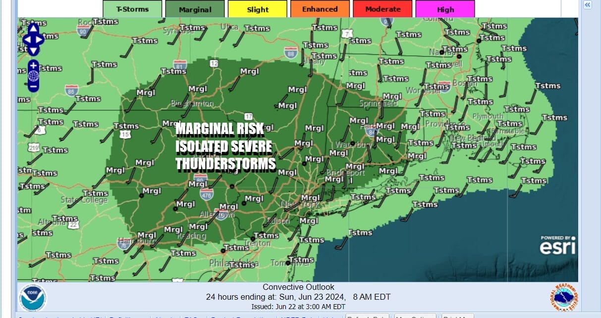
A cold front is approaching from the Ohio Valley and the Great Lakes and a strong upper trough is rotating through the Great Lakes and Southeastern Canada, strengthening along the way. The approaching front and the massive daytime heating in a hot and unstable airmass creates the opportunity for widespread shower and thunderstorm activity later Sunday afternoon into Sunday night and elevated risks for severe thunderstorms and even tornadoes.

Severe thunderstorms could occur from Maine to New Hampshire, Vermont and much of New York State southward to Maryland and Virginia, west to the Ohio Valley. Of particular concern is the area from Pennsylvania and Northern New Jersey northward to Northern New England in the slight risk zone. There is an elevated 2 to 5 percent risk for tornadoes as storms play through. Bear this in mind if you are pursuing outdoor activities Sunday and it would be wise to keep an eye on weather conditions during the afternoon.

The good news is that the cold front will break the back of this heatwave as Monday will be a cooler and less humid day. However it will still be very warm across the Northeast and Mid Atlantic with highs mostly in the mid to upper 80s. The break however is short lived as temperatures will be back into the upper 80s to lower 90s Tuesday with sunshine and little in the way of thunderstorm activity. Wednesday could be another brutally hot and humid day in the mid to upper 90s but we have another cold front and another chance for widespread shower and thunderstorm activity as well as severe weather risk.
BE SURE TO DOWNLOAD THE FREE METEOROLOGIST JOE CIOFFI WEATHER APP &
ANGRY BEN’S FREE WEATHER APP “THE ANGRY WEATHERMAN!
MANY THANKS TO TROPICAL TIDBITS FOR THE USE OF MAPS
Please note that with regards to any severe weather, tropical storms, or hurricanes, should a storm be threatening, please consult your local National Weather Service office or your local government officials about what action you should be taking to protect life and property.
(Amazon is an affilate of Meteorologist Joe Cioffi & earns commissions on sales.)


