
Severe Thunderstorm Risk Next 3 Days As Heatwave Continues Through Sunday

Severe Thunderstorm Risk Next 3 Days As Heatwave Continues Through Sunday
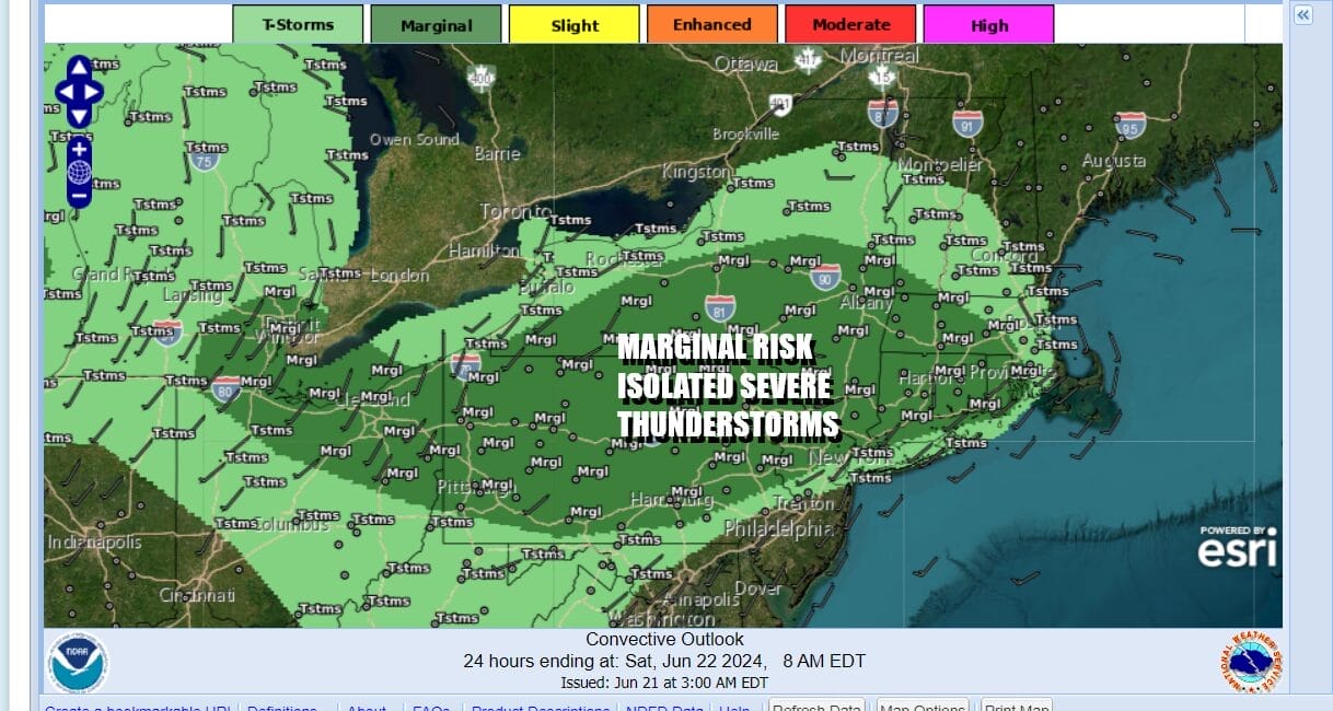
We have arrived at the end of the work week and the heatwave continues across much of Eastern Pennsylvania to Southern New England. Wind direction with a southerly component has kept areas from NYC to Long Island and Southern Connecticut cooler than areas well inland. As the hottest air shifts southward, we see risk for some scattered thunderstorms today and the risk for severe weather from Pennsylvania, across Northern New Jersey into Southern New England and the Hudson Valley. It is a marginal risk which means that there is the chance for isolated severe thunderstorms in the late afternoon and evening.
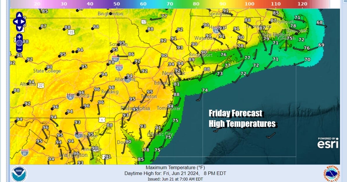
Most highs today will be in the low to mid 90s. Satellite loops show mostly cloud free conditions so we will have lots of sunshine and ample daytime heating. A weak upper trough and frontal boundary to the north will sink southward today. This will serve as the mechanism to set off some scattered thunderstorms. The best chances will be inland north and west of the coast. Temperatures along the Jersey shore as well as Long Island and South Coastal Connecticut will be in the cooler 80s thanks to a south wind.
SATELLITE WITH LIGHTNING STRIKES

WEATHER RADAR

Once any thunderstorms move through we will see warm and humid conditions overnight with Saturday morning lows in the upper 60s to mid 70s. The weekend for most will be hot and humid. Sunshine will once again take highs to the low and middle 90s in most places. The exception again will be east of NYC across Long Island and South Coastal New England where it will be mostly in the 80s though we could see some 90 degree highs just inland of the coast.

Once again we will probably see scattered thunderstorms develop in parts of the area during the late afternoon and evening. Some of you might see a thunderstorm and some of you won’t. There is severe weather risk for Saturday but it is more inland and the risk is for isolated severe thunderstorms.
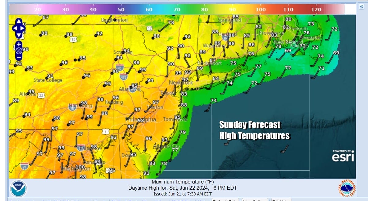
Sunday looks to be the hottest day of this stretch of hot weather. Southwest winds ahead of an approaching cold front will set up for an oppressive day. Sunshine will take highs to the mid to upper 90s. Temperatures along coastal areas will reach the 80s to near 90 degrees. Humidity levels will be very high as dew points push up into the lower 70s in many areas.
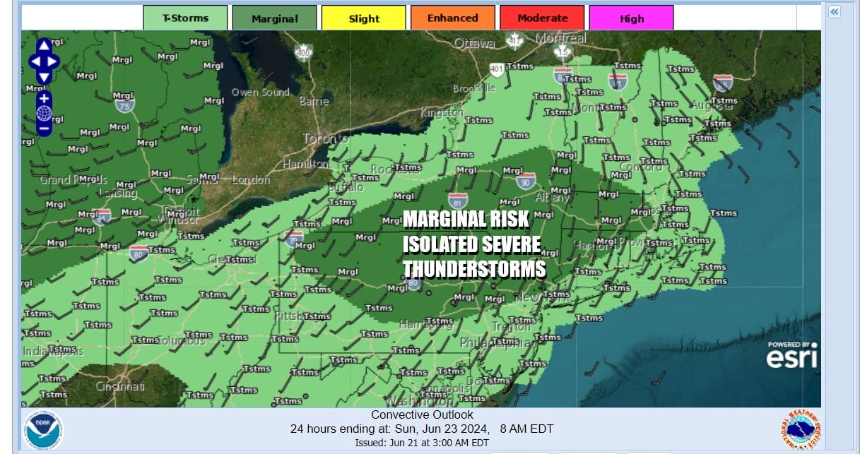
A cold front will approach from the west Sunday afternoon and evening as a strong upper trough swings across the Great Lakes. Northwest winds in the upper atmosphere are increasing as the heat ridge weakens and moves southward. This will allow the cold front to move through and eventually pass the Northeast and Middle Atlantic states. Ahead of the front showers and thunderstorms are likely to develop and the activity will be more widespread. Severe weather risks are on the table for a third day and while the risk is currently at the marginal level, we would not be surprised to see the risk raised to a higher level by the time we reach Sunday.
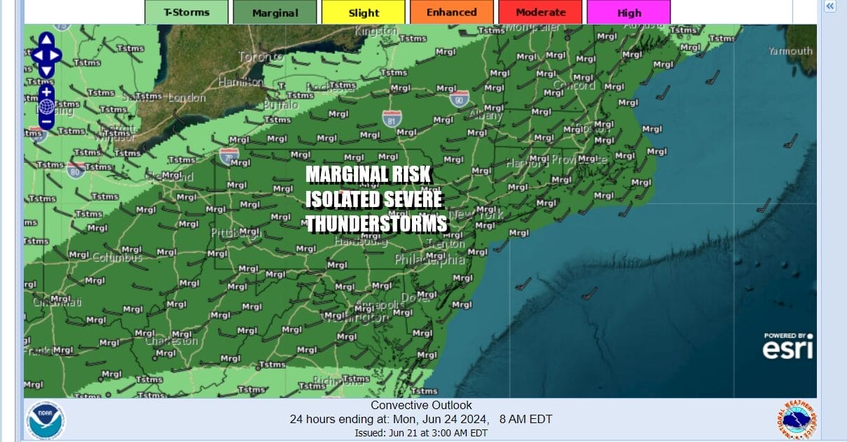
The risk area extends south to Virginia, west to Ohio and Northeast into Maine so it covers much of the Northeast, Mid Atlantic and the Central Appalachians to the Ohio Valley. The front passes offshore Monday morning and next week we will see a short break from the humidity for a day or so. Temperatures will remain very warm though not as high as this weekend. Another cold front is going to arrive midweek bringing another chance for showers and thunderstorms.
BE SURE TO DOWNLOAD THE FREE METEOROLOGIST JOE CIOFFI WEATHER APP &
ANGRY BEN’S FREE WEATHER APP “THE ANGRY WEATHERMAN!
MANY THANKS TO TROPICAL TIDBITS FOR THE USE OF MAPS
Please note that with regards to any severe weather, tropical storms, or hurricanes, should a storm be threatening, please consult your local National Weather Service office or your local government officials about what action you should be taking to protect life and property.
(Amazon is an affilate of Meteorologist Joe Cioffi & earns commissions on sales.)


