
Heat Humidity & Severe Weather Risk Well Inland
as Northeast Heatwave Continues

Heat Humidity & Severe Weather Risk Well Inland
as Northeast Heatwave Continues
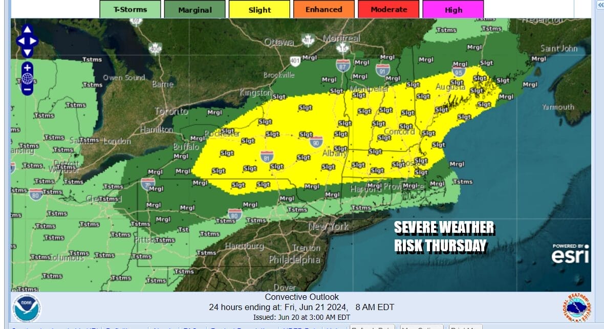
Heat and humidity often times bring thunderstorm activity but so far we have see only some scattered thunderstorms & isolated severe thunderstorms pop up well inland. Today could be a little different as a weak weather front is dropping southward through New New England and Upstate NY and that could set off some thunderstorms and severe weather. The Storm Prediction Center has a slight risk for severe weather across Upstate NY eastward through much of Central and Northern New England. The storms basically cut off south of Route 84 so I do not expect much activity for New Jersey, coastal Southern New England and Long Island. These storms will likely fire up later this afternoon into the first part of tonight.
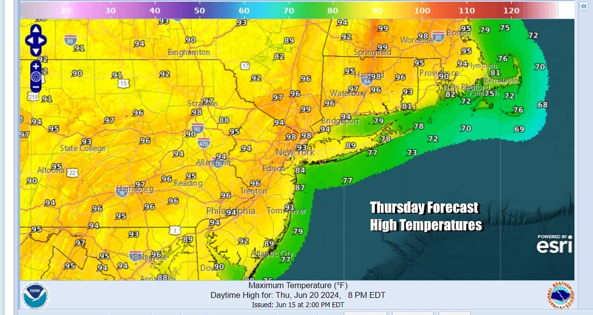
The heatwave continues in most of the interior Northeast today. The hottest air so far has been across Northern NY and especially in Northern New England. High temperatures there have been in the mid to upper 90s and most people in Northern New England don’t have air conditioners. Meanwhile it has been hot (away from the ocean) and it has been humid in Eastern Pennsylvania but so far it has been mostly low 90s for highs. Today we could see highs reach the low to middle 90s in many inland locations with cooler readings again along the immediate shore.
SATELLITE WITH LIGHTNING STRIKES

WEATHER RADAR

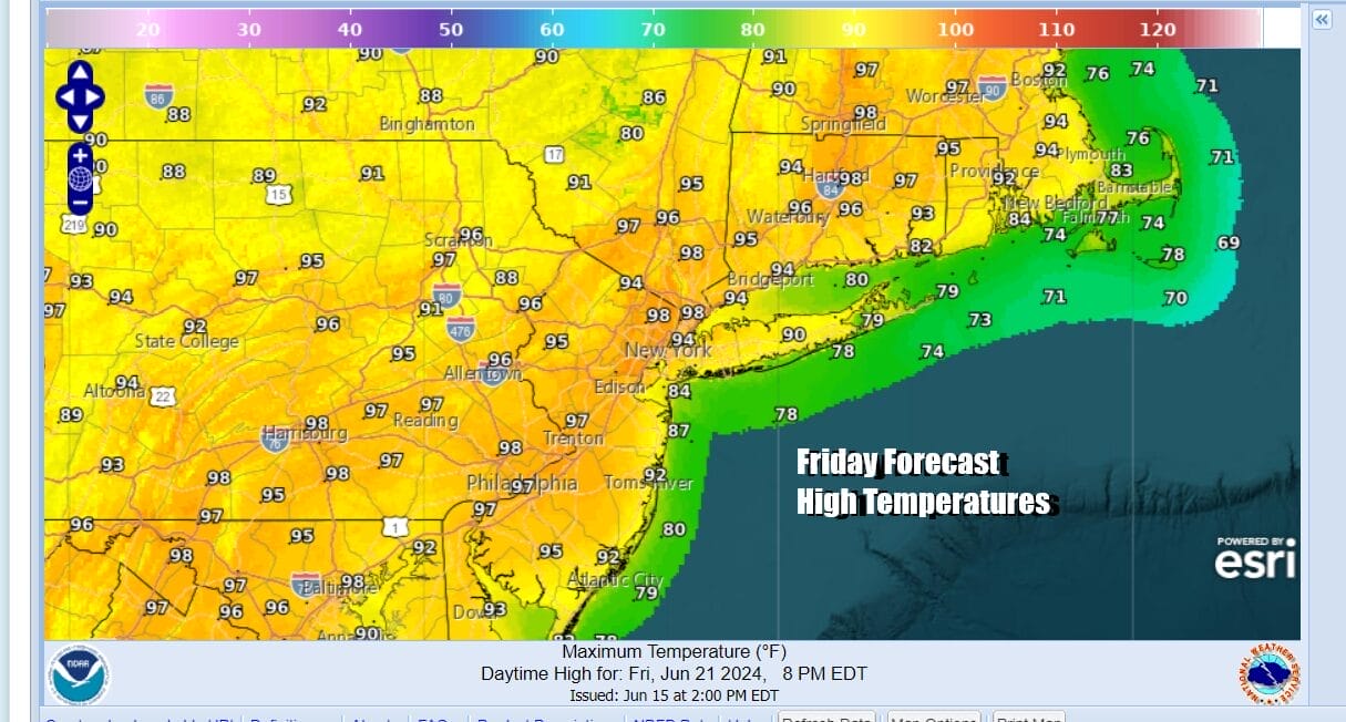
As we move along to Friday and the weekend, this weak weather front will shift southward Friday. Also shifting southward will be the hottest air as it cools off in Northern and Central New England. We will see sunshine taking highs up to the middle 90s in many areas Friday. It will be a little cooler at the shore but more of a west wind will allow coastal areas to warm up to near 90 degrees before any local sea breezes develop.
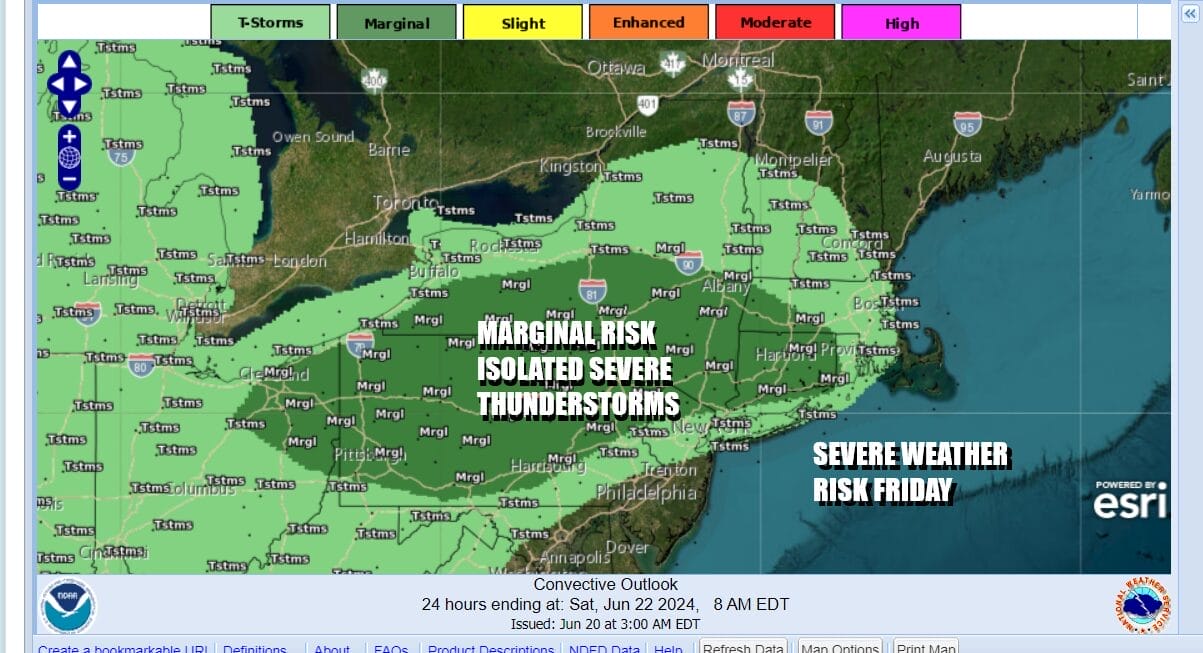
 The weak weather front being further south across Southern New England the middle part of Upstate NY causes the risk for thunderstorms and severe weather to shift a little further south Friday. The Storm Prediction Center has indicated a marginal risk for isolated severe thunderstorms Friday from Pennsylvania to Northern New Jersey east to Southern New England. Thunderstorm chances cut off across Central New Jersey.
, Saturday will be hot in some places and not so hot in others. The weak front falls apart and we will have more of a south wind. This means that areas from NYC north and east will top out in the mid to upper 80s while it will be hot across interior Southern New Jersey westward into Southern Pennsylvania. Those areas will see highs reach the middle 90s. Thunderstorm activity Saturday should be isolated at best.

The “heat ridge” as it is known will continue to weaken over the weekend. Northwest winds in the upper atmosphere sink southward and this will allow a cold front from the Great Lakes and Ohio Valley to approach. Ahead of this front it will be hot and humid with some sunshine. Highs will be in the 90s just about everywhere. Then the front will near the coast and we see a high chance for showers, thunderstorms and possibly some severe weather late in the Sunday into Sunday night.

We should get a break from the humidity Monday into Tuesday though temperatures will only ease slightly. The pattern next week will allow another cold front to approach mid week so we may get hot again for a day or two before another front passes with showers and thunderstorms ahead of it.
BE SURE TO DOWNLOAD THE FREE METEOROLOGIST JOE CIOFFI WEATHER APP &
ANGRY BEN’S FREE WEATHER APP “THE ANGRY WEATHERMAN!
MANY THANKS TO TROPICAL TIDBITS FOR THE USE OF MAPS
Please note that with regards to any severe weather, tropical storms, or hurricanes, should a storm be threatening, please consult your local National Weather Service office or your local government officials about what action you should be taking to protect life and property.
(Amazon is an affilate of Meteorologist Joe Cioffi & earns commissions on sales.)


