Temperatures Heading Higher Next Several Days 90 Degree Plus Highs Continue

Temperatures Heading Higher Next Several Days 90 Degree Plus Highs Continue
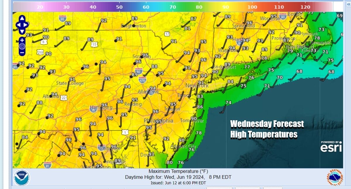
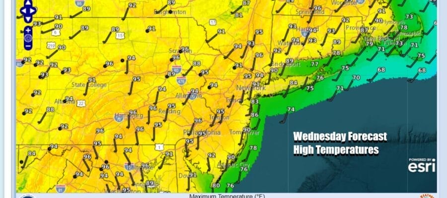
The hot weather continues today as we have mainly clear skies on satellite loops and nothing more than some patchy clouds here and there. Sunshine will take highs to the low and middle 90s away from the ocean. Once again temperatures are cooler along shore locations of New Jersey, Long Island and Southeast New England. Highs along the coast will be in the 80s and the local sea breeze will knock temperatures down in the afternoon and evening. Dew points are generally in the 60s which makes things uncomfortable but we seem to avoiding dew points sitting close to or over 70 which would make it very uncomfortable to oppressive.
SATELLITE WITH LIGHTNING STRIKES

WEATHER RADAR

We have seen scattered thunderstorms pop up in areas well inland (north of Route 84) and this is probably going to be the case again today. The vast majority of you won’t see a thunderstorm. A warm humid night lies ahead with most lows in the mid 60s to around or just over 70 degrees. Thursday it will be hot and humid with highs reaching the middle 90s in most places.
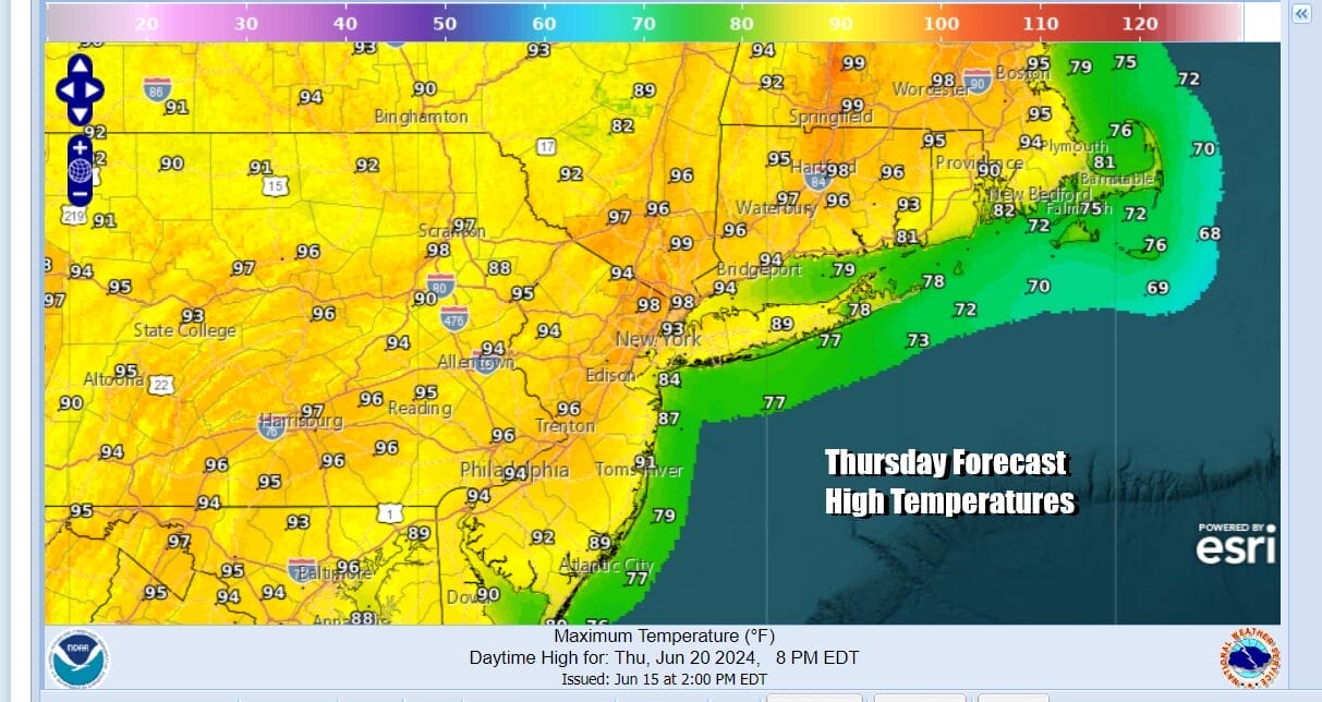
Thunderstorm risk increases a bit Thursday and shifts a little further south thanks to an upper trough and a weak weather front dropping southward from Eastern Canada. Thunderstorms across Upstate NY and New England look to be more numerous late Thursday into Thursday night but they will likely weaken as they move southeastward. There is the odd chance that one or two could survive the trip south Thursday night.

Another weak front will approach late Friday and Friday night from the north and this front also will likely fall apart as it nears Eastern Pennsylvania to Southern New England. We will need to wait until late Sunday or even Monday for a more impressive front to approach and pass and at least bringing some lower humidity and slightly lower temperatures next week.
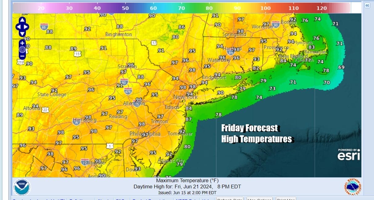
Until then we will continue to see hot and humid conditions with sunshine Friday taking highs into the middle and a few upper 90s. Watch for a scattered thunderstorm Friday night. Saturday sees the front falling apart so it is another hot day with temperatures in the 90s. Models are backing off on the extreme highs that were being shown days ago.

Sunday will be hot and humid with sunshine into the afternoon and highs in the 90s. Then as a cold front makes a move through the Northeast we could see some thunderstorms developing late Sunday and then depending on the speed of the front, some shower and thunderstorm activity will linger into Monday.
BE SURE TO DOWNLOAD THE FREE METEOROLOGIST JOE CIOFFI WEATHER APP &
ANGRY BEN’S FREE WEATHER APP “THE ANGRY WEATHERMAN!
MANY THANKS TO TROPICAL TIDBITS FOR THE USE OF MAPS
Please note that with regards to any severe weather, tropical storms, or hurricanes, should a storm be threatening, please consult your local National Weather Service office or your local government officials about what action you should be taking to protect life and property.
(Amazon is an affilate of Meteorologist Joe Cioffi & earns commissions on sales.)


