Very Cool Below Normal Temperatures Much of the East For the Week Ahead

Very Cool Below Normal Temperatures Much of the East For the Week Ahead

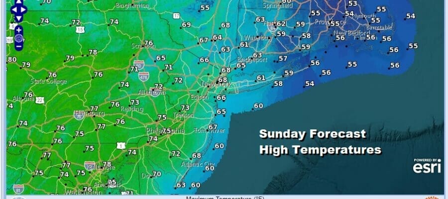
The backdoor cold front has now made its way down to Southern Georgia while the flow of air in the Eastern US is dominated by a storm system off the coast of New England. Dry air has wedged itself from NYC south to Delaware but there will be some clouds that will fill in during the day. We are at the time of year where temperatures should be reaching into the 80s on an almost daily basis but not this week and certainly not today. We will describe sky conditions ranging from partly sunny to mostly cloudy with more sun west and less east. High temperature forecasts today reflect this as we see highs in the lower 70s to the west and barely out of the 50s to the east.
SATELLITE

WEATHER RADAR

The rotating low in the Gulf of Maine will likely bring some rain showers to Southeastern New England todayb into tonight but everyone else should be dry as the radar is not showing much activity outside of what is rotating around that coastal low. That system will be meandering around Eastern New England and Southeastern Canada all week long which means that the Eastern US will be in a scheme of below average temperatures along with very dry conditions much of the time.

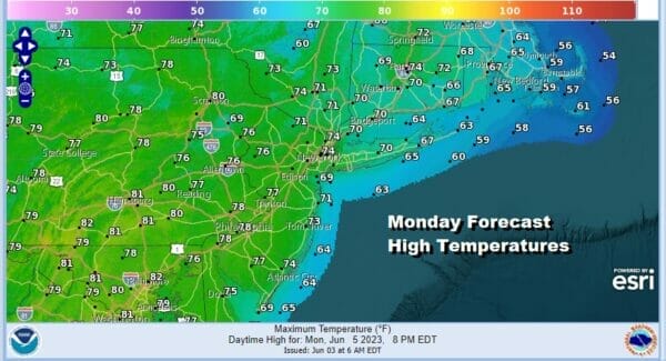
The day to day forecast challenges will be how cold and unstable the atmosphere will be as we sit under an upper trough in the East all this week. Monday looks to me like it should be no worse than partly sunny. Highs will likely go up a but Monday and reach into the 70s in most inland areas.
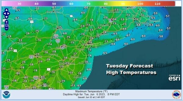
Tuesday may be one of those days this week where we have to pay some attention to the upper atmosphere as an upper trough moves around an upper low to the northeast and drops southward through upstate NY to the coast. This leads me to think that there is the chance we could see scattered showers and thunderstorms Tuesday afternoon and evening with highs in the 70s
This trough will move offshore and leave us in a dry cool northwest flow Wednesday with some sunshine but again it will be on the cool side. Highs Wednesday will be in the upper 60s and lower 70s. We may edge a bit higher in the 70s Thursday and Friday with some sunshine. The pattern will shift a bit next weekend and that could open the door for some rain chances next week though dry patterns tend to want to hold on tight until a strong catalyst shows up to break that part of the pattern down.
BE SURE TO DOWNLOAD THE FREE METEOROLOGIST JOE CIOFFI WEATHER APP &
ANGRY BEN’S FREE WEATHER APP “THE ANGRY WEATHERMAN!
MANY THANKS TO TROPICAL TIDBITS FOR THE USE OF MAPS
Please note that with regards to any severe weather, tropical storms, or hurricanes, should a storm be threatening, please consult your local National Weather Service office or your local government officials about what action you should be taking to protect life and property.
(Amazon is an affilate of Meteorologist Joe Cioffi & earns commissions on sales.)


