
Big Temperature Change 20 to 30 Degrees Lower
Below Average Temperatures Next Week

Big Temperature Change 20 to 30 Degrees Lower
Below Average Temperatures Next Week
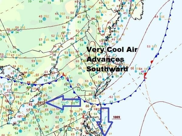
Yesterday was a hot day and the cuminated in showers and thunderstorms in some places but not others. A cold frong moving southwestward from New England has now passed through and it continues to drop southward through New Jersey and into the Mid Atlantic states. Very cool air from Eastern Canada is streaming southward on northeast winds and it will make for a much different type of day and weekend.
Yesterday we saw highs in the low to middle 90s. Today many of those areas that were above 90 will be in the 60s and some will be struggling to get to 60 such as areas with south and east facing shorelines and Southeastern New England which will be in the 50s for highs. Inland in Western New Jersey and points westward highs will be in the 70s but they may ease back as the cooler air takes hold. Sky conditions today are a bit tough to figure and will range from overcast to in some cases, partly sunny so we will describe them as changeable sky conditions. There might be a stray shower or two inland but most of the area will be on the dry side.
SATELLITE

WEATHER RADAR

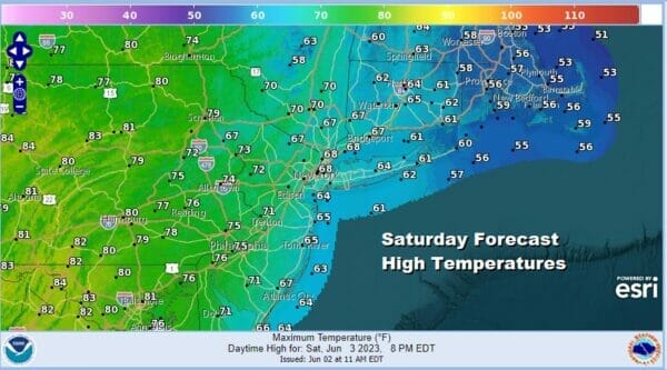
This is going to be a cool Saturday night into Sunday morning as skies attempt to partially clear inland but clouds may hold along the coast. Most lows will be in the 40s except near 50 in warmer urban areas. Sunday we see low pressure that will develop off the coast of Southeastern New England but it will be far enough northeast that we escape any rain issues.

That low however will be a driving force this coming week as it will keep us locked into a rather cool weather pattern for June with northwest winds aloft and below normal temperatures. Back to Sunday we see a day where we will have a mix of sun and clouds. Probably there will be more sun as you head west and southwest and less as you head northeast. Highs Sunday will be in the 60s except inland where highs will reach into the 70s.

Next week does not hold out hope for much in the way of rain. The only chance for showers early in the week will be up in New England where they will be close to a deep upper trough and that will produce instability showers. Otherwise it is going to be cool and dry for the most part. Monday looks to be a nice day of partly to mostly sunny skies.
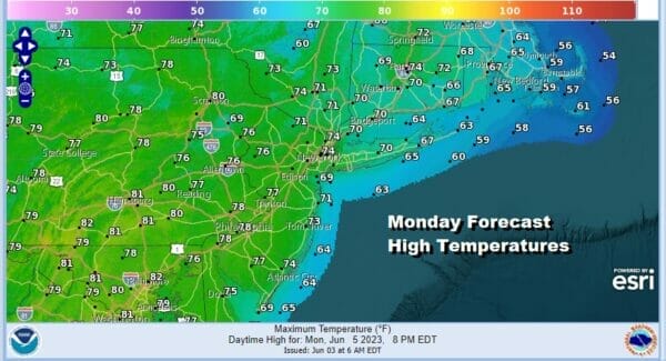
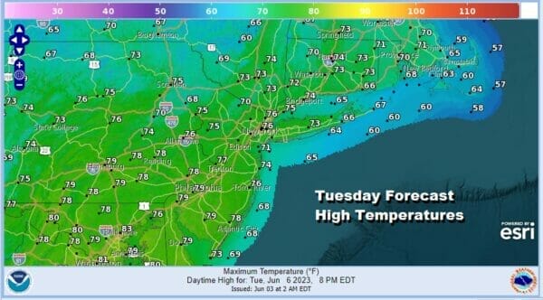
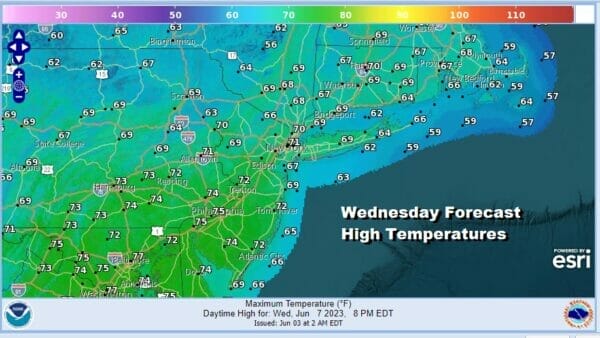
A weak upper trough will move through Monday night and early Tuesday with not much weather with it other than maybe a few clouds but it does bring down a re-enforcement of cool air. Tuesday sees a mix of sun and clouds with highs in the mid to a few upper 70s. Wednesday looks to be cooler with sunshine and some clouds and highs just in the upper 60s to lower 70s.
We will see temperatures moving higher Thursday and Friday as both days will feature sunshine. Highs Thursday will be in the 70s and Friday we could see highs in the upper 70s to some lower 80s. We may see a chance for some late showers Friday as another front approaches from northwest and passes but it doesn’t appear to be anything widespread so the mostly dry pattern continues into next weekend.
BE SURE TO DOWNLOAD THE FREE METEOROLOGIST JOE CIOFFI WEATHER APP &
ANGRY BEN’S FREE WEATHER APP “THE ANGRY WEATHERMAN!
MANY THANKS TO TROPICAL TIDBITS FOR THE USE OF MAPS
Please note that with regards to any severe weather, tropical storms, or hurricanes, should a storm be threatening, please consult your local National Weather Service office or your local government officials about what action you should be taking to protect life and property.
(Amazon is an affilate of Meteorologist Joe Cioffi & earns commissions on sales.)


