Heat Today Thunderstorms Late Inland Sharply Cooler Over the Weekend

Heat Today Thunderstorms Late Inland Sharply Cooler Over the Weekend
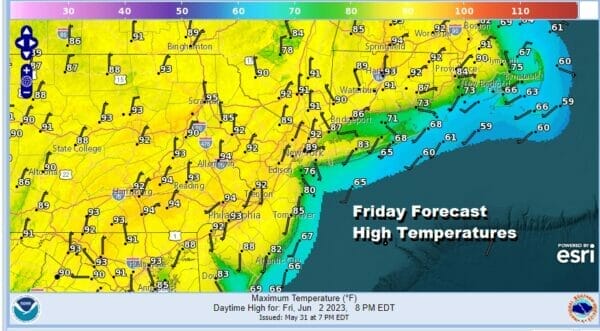
The onshore flow from earlier this week is gone and this sets us up for a hot day in Eastern Pennsylvania to Southern New England. We will have sunshine and temperatures will be headed into th 90s in many inland areas. Cooler temperatures will be confined to the coast and the beaches and as you head into these areas, temperatures will step down to the 80s and 70s.

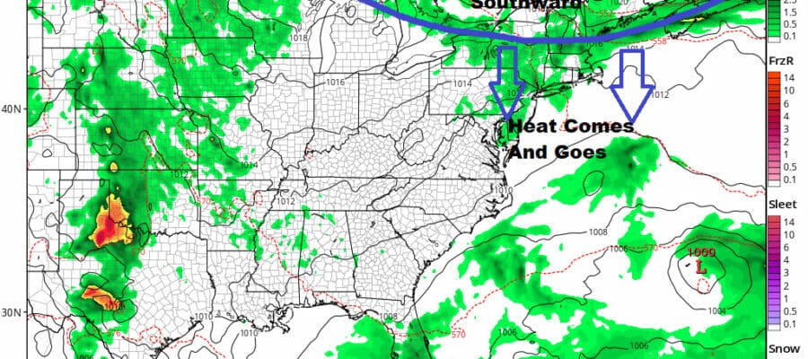
There is the risk that there could be a shower or thunderstorm this evening and for part of tonight but I have been arguing all week that I am not very bullish on thuunderstorm develoment. Yes some strong cells could form in Upstate NY, (middle and upper Hudson Valley) Northern Ct, Rhode Island and Massachusetts, but as they move southward I believe they will weaken except over Southeastern New England where the upper air energy is concentrated.
SATELLITE

WEATHER RADAR

This cold front tonight is moving northeast to southwest which is a little unusual and the front will be followed by high pressure in Eastern Canada that will build southwestward into the Northeast and Mid Atlantic states. This means there will be a sharp change in temperatures Saturday. In some places we are looking at 30 degree or higher changes from today’s highs.
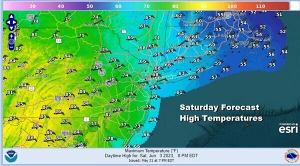
While these are the forecast high temperatures for Saturday, some of these highs will occur early in the day until the front reaches areas in Southern Pennsylvania and Southern New Jersey. Highs there will be in the upper 70s and lower 80s. However you will see 60s from Northeast New Jersey eastward and parts of Southern and Southeastern New England will not get out of the 50s. Eventually everyone will be in the cooler air mass. We will probably have changeable sky conditions Saturday until the front completely moves through. A few scattered showers can’t be ruled out along with maybe some spotty drizzle along the coast.
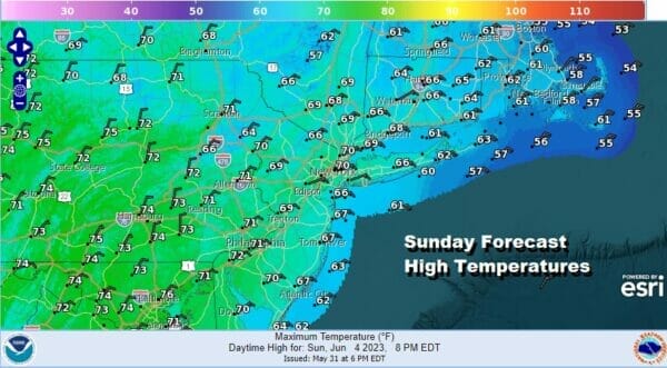
Sunday looks to be a cool day with high pressure overhead. It will be a day of sunshine and fewer clouds. Highs Sunday will reach the upper 60s to lower 70s though some coastal areas will likely be a few degrees cooler. No showers are forecast for Sunday.

Next week is going to be cooler than average overall as a northwest flow from Canada continues to send down cool air masses. We will be into the 70s Monday with sunshine and some late clouds. A cold front moving through likely comes through dry. Then Tuesday through Thursday will be very cool with highs in some areas in the 60s and the warmest spots might reach into the 70s. No rain is forecast all week long.
BE SURE TO DOWNLOAD THE FREE METEOROLOGIST JOE CIOFFI WEATHER APP &
ANGRY BEN’S FREE WEATHER APP “THE ANGRY WEATHERMAN!
MANY THANKS TO TROPICAL TIDBITS FOR THE USE OF MAPS
Please note that with regards to any severe weather, tropical storms, or hurricanes, should a storm be threatening, please consult your local National Weather Service office or your local government officials about what action you should be taking to protect life and property.
(Amazon is an affilate of Meteorologist Joe Cioffi & earns commissions on sales.)


