
Very Cold Dry Weather Through The Weekend
Weak Front Sunday Tuesday No Major Storms

Weather in 5/Joe & Joe Weather Show Latest Podcast
Very Cold Dry Weather Through The Weekend
Weak Front Sunday Tuesday No Major Storms
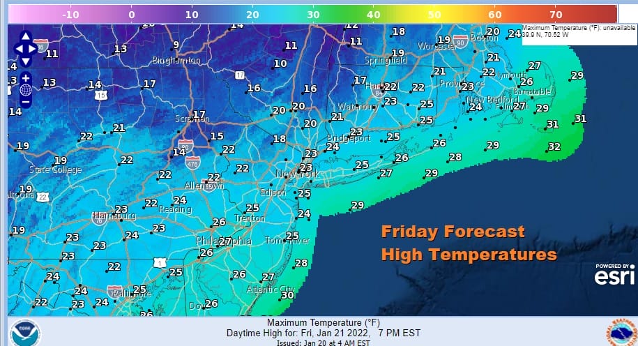
Another very cold air mass has built in the the Northeast and that cold air has actually drained south into Florida. Troughing in the Eastern US is not favorable for major or even minor storms which is why the clouds to the south across Virginia and North Carolina are moving eastward. Low pressure developing there will bring snow and ice later today and today in Eastern North Carolina and Southeast Virginia. Winter Storm Warnings are up there. That storm is moving out to see so we will just see a day of ineffective sunshine and highs that will just reach 20 to 25. Areas well inland will not get out of the teens.
SATELLITE

WEATHER RADAR

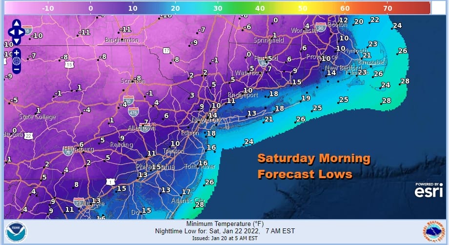
The northeast regional radar is nice and quiet. The position of the high in the Saint Lawrence Valley is not favorable for lake effect snows in upstate NY. Late today and tonight we will see radar echoes to the south and east and sliding to the east. Skies tonight should be partly to mostly clear though some high clouds might sneak in for a short time. Lows Saturday morning will be in the low teens warmer urban areas and coast, single digits inland and below zero well inland.
Saturday will be a day of sunshine but another day of cold temperatures with highs in the low to mid 20s. Then we head down again to the teens to low 20s Saturday night as the cold air mass modifies. Sunday we have a weak front approaching that won’t have much with it other than some clouds. We will see some sun in the mix too with highs back into the 30s.

Next week looks to be quiet and mostly on the cold side. Monday we will be a little colder again with highs in the mid 20s to lower 30s with some sunshine. An arctic front will be approaching Tuesday similar to what we saw yesterday. There will be some gulf moisture moving north but that looks to stay separate and on the weak side. For now we will call for cloudy skies. North and west of the coast there could be a period of snow that that doesn’t amount to much with some rain showers along the coast. Another cold dry Canadian air mass follows. There are mixed signals coming from the models for the last weekend of January but there really isn’t much specifically that we can discuss at the moment so we will leave that alone for now. Longer term there are some hints of a pattern shift with a ridge coming back to the east and a trough going back to the west, but here too we don’t have a whole lot of clarity at this point.
BE SURE TO DOWNLOAD THE FREE METEOROLOGIST JOE CIOFFI WEATHER APP &
ANGRY BEN’S FREE WEATHER APP “THE ANGRY WEATHERMAN!

MANY THANKS TO TROPICAL TIDBITS & F5 WEATHER FOR THE USE OF MAPS
Please note that with regards to any severe weather, tropical storms, or hurricanes, should a storm be threatening, please consult your local National Weather Service office or your local government officials about what action you should be taking to protect life and property.


