
Very Chilly April Cold & Wind Into Wednesday
Rain Late Week From A Coastal Storm
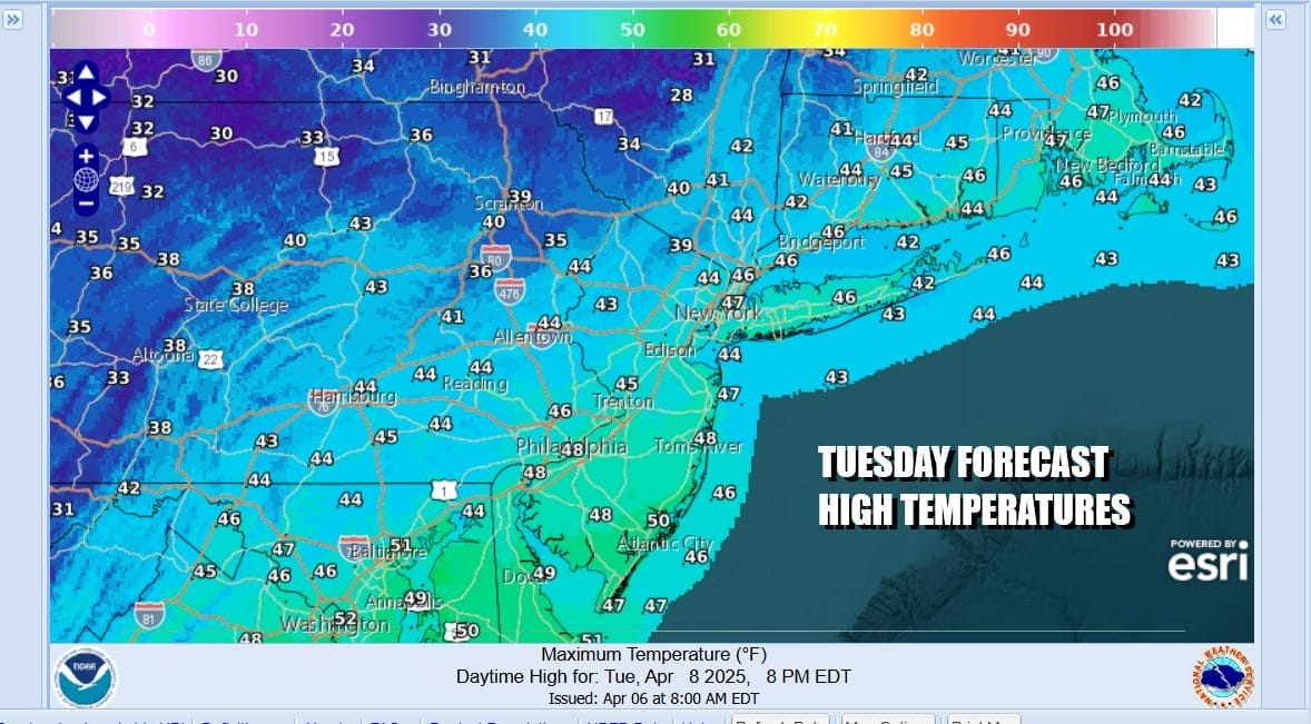
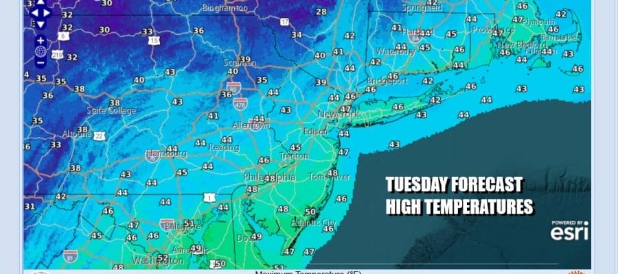
We have a rather cold air masses that has come down from Canada. Much of the Eastern US is experiencing below average temperatures for the next couple of days. We will be running about 15 degrees below seasonal norms. That means that high temperatures today across Eastern Pennsylvania to Southern New England will not get out of the 40s. If we seasonally adjust this air mass for say January, that would mean days with highs only in the upper teens and lower 20s and lows in the single digits. Thankfully it is not January. There will be a gusty northwest wind today making those highs feel at least 10 degrees colder. At least we will have a decent amount of sunshine.
SATELLITE WITH LIGHTNING STRIKES

WEATHER RADAR

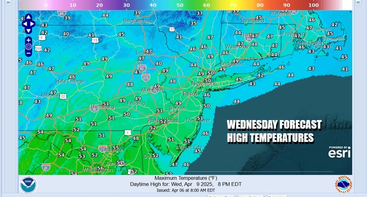
We are also setting up for a rather cold night. Skies should be partly to mostly clear and Wednesday morning lows will be in the mid 20s inland areas and lower 30s coast and warmer urban locations. Wednesday dayside will be another chilly day but we should have less in the way of wind. Sunshine will take highs back only to the upper 40s to around 50 degrees in most places.
We will see the core of the cold air mass begin to move out Thursday but we also going to see weather conditions slowly descend into a springtime abyss. Low pressure will be heading southeast from the Western Great Lakes and dropping into the Central Appalachians. An approaching and dying front will bring clouds and some scattered showers late Thursday or Thursday night but. the more important feature is a developing low in the Central Appalachians Friday.

This low heads up the coast Friday into Saturday along or just offshore. You can expect to see an area of rain develop north of the low and spread northward up the coast. Rain and a gusty northeast wind is likely late Friday into at least part of Saturday. Then the question will be how long does it take the low to exit to the northeast. This could mean on shore winds, clouds, & gloom & doom conditions last into Sunday though rain may be mostly offshore and to the east.
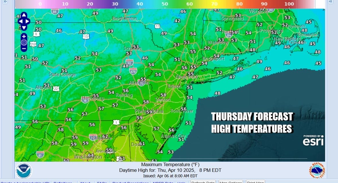
Back to Thursday we see temperatures moderating sun with early sun and increasing clouds with highs in the 50s. Friday look for cloudy skies with some leftover showers early, and then a steadier rain developing late in the day Friday or Friday night. Highs will be in the 50s. Rainfall could be on the order of an inch to an inch an a half for Friday night into Saturday. Temperatures will likely be in the 40s to lower 50s at best while this storm system heads northward. We should point out that we are heading into a full moon this weekend and that will mean higher than average spring tides and coastal flooding are a solid possibility.
BE SURE TO DOWNLOAD THE FREE METEOROLOGIST JOE CIOFFI WEATHER APP &
ANGRY BEN’S FREE WEATHER APP “THE ANGRY WEATHERMAN!
MANY THANKS TO TROPICAL TIDBITS FOR THE USE OF MAPS
Please note that with regards to any severe weather, tropical storms, or hurricanes, should a storm be threatening, please consult your local National Weather Service office or your local government officials about what action you should be taking to protect life and property.


