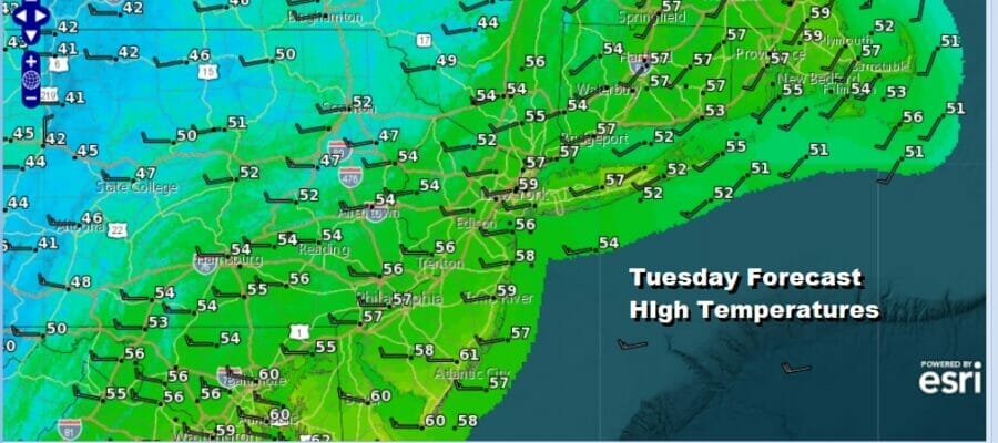
Unstable Atmosphere On & OFF Showers Next Few Days
Below Average Temperatures

Unstable Atmosphere On & OFF Showers Next Few Days
Below Average Temperatures
The strong upper low that has been over the Great Lakes and Southeastern Canada remains pretty much in the same place. The storm continues to rotate in counterclockwise fashion with spokes of energy rotating around. With each spoke we have some showers and even the isolated low top thunderstorm while in between spokes we have clouds mixed with sunshine.

It is a very unstable and cold atmosphere aloft that continues to drive this chilly pattern. Temperatures today will probably not get out of the 50s once again. Gusty west to northwest winds will continue at 20 to occasionally 30 mph. It all makes for late March in early May weather.
SATELLITE

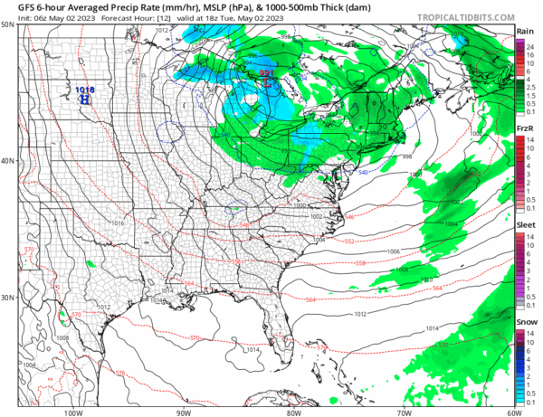
WEATHER RADAR

We do have some rain and shower activity around today as you see the band on the regional radar that runs from west to east. It is an uneven band and it is raning in some places and not in others. This will be the case throughout the day with probably some breaks of sunshine in between. Tonight we will see some cloudsa around with the chance for a shower. Lows will be in the 40s with 30s well inland.
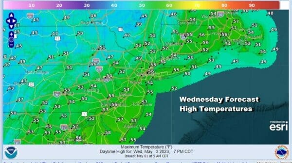
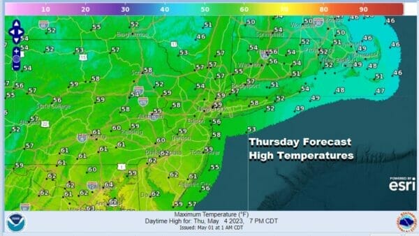
Wednesday we will see low pressure over the Great Lakes move southeast and redevelop off the New Jersey coast. This is going to leave us in another day with clouds around and some showers from time to time and from place to place. Highs again will be in the 50s. The low develops offshore southeast of Cape Cod and Thursday will be another day with clouds and the chance for showers with highs in the 50s.
It does appear that we will finally see the atmosphere start to stabilize Friday with more sun, fewer clouds and maybe no showers with highs in the 50s to near 60 degrees. Then as we head into the weekend we will see a nice dry air mass and high pressure build southward from Eastern Canada and that will keep the East Coast dry wtih sunshine for both Saturday and Sunday. Saturday highs will be in the mid to upper 60s and Sunday highs should reach into the 70s!
BE SURE TO DOWNLOAD THE FREE METEOROLOGIST JOE CIOFFI WEATHER APP &
ANGRY BEN’S FREE WEATHER APP “THE ANGRY WEATHERMAN!
MANY THANKS TO TROPICAL TIDBITS & F5 WEATHER FOR THE USE OF MAPS
Please note that with regards to any severe weather, tropical storms, or hurricanes, should a storm be threatening, please consult your local National Weather Service office or your local government officials about what action you should be taking to protect life and property.


