Tropical Storm Warning Cancelled New Jersey
Tropical Storm Warning Cancelled for New Jersey,
NYC, Southern Westchester, & Western Long Island
& Connecticut West of New Haven
Tropical Storm Warning Remains In Effect Connecticut
From New Haven Eastward & Eastern Long Island
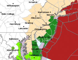
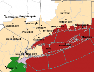
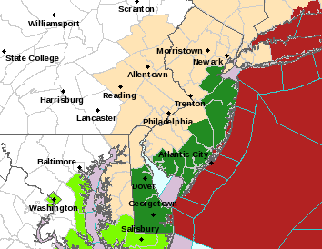
The National Hurricane Center has cancelled all warnings for New Jersey but they remain in effect for Central & Eastern coastal Connecticut and Central & Eastern Long Island including the surrounding coastal waters. Hermine has been intensifying some tonight and a band of heavy squalls is developing in the ocean that is forecast to swing westward overnight into Monday. This could bring some brief heavy rains along with some wind gusts to gale force at times into Monday afternoon for some areas in the warning zone. Areas west of there are done.


Coastal Flooding is probable at high tide on Monday and tides could run 2 to 4 feet above normal. Coastal flooding should be minor to moderate in nature in most areas.
...HERMINE EXPECTED TO MEANDER OFF THE MID-ATLANTIC COAST DURING
THE NEXT DAY OR TWO...


SUMMARY OF 1100 PM AST...0300 UTC...INFORMATION
-----------------------------------------------
LOCATION...37.2N 68.5W
ABOUT 325 MI...525 KM SE OF THE EASTERN TIP OF LONG ISLAND
MAXIMUM SUSTAINED WINDS...70 MPH...110 KM/H
PRESENT MOVEMENT...NNE OR 20 DEGREES AT 3 MPH...6 KM/H
MINIMUM CENTRAL PRESSURE...997 MB...29.44 INCHES


WATCHES AND WARNINGS
--------------------
CHANGES WITH THIS ADVISORY:

The Tropical Storm Warning has been discontinued west and south of
Fire Island Inlet, west of Port Jefferson, and west of New Haven.

SUMMARY OF WATCHES AND WARNINGS IN EFFECT:

A Tropical Storm Warning is in effect for...
* The coast of Long Island from Fire Island Inlet to Port Jefferson
Harbor
* New Haven to Sagamore Beach
* Block Island
* Martha's Vineyard
* Nantucket

For storm information specific to your area, including possible
inland watches and warnings, please monitor products issued by your
local National Weather Service forecast office.


DISCUSSION AND 48-HOUR OUTLOOK
------------------------------
At 1100 PM AST (0300 UTC), the center of Post-Tropical Cyclone
Hermine was located near latitude 37.2 North, longitude 68.5 West.
The post-tropical cyclone is moving toward the north-northeast near
3 mph (6 km/h).  A turn toward the north with a decrease in forward
speed is expected tonight, followed by a slow north-northwestward
motion on Monday.  A northeastward motion is expected to begin on
Tuesday.  On the forecast track, the center of Hermine will meander
slowly offshore of the mid-Atlantic coast for the next couple of
days.

Maximum sustained winds are near 70 mph (110 km/h) with higher
gusts.  Hermine should remain near hurricane strength through
Monday.  Gradual weakening is forecast to begin by Monday night.

Tropical-storm-force winds extend outward up to 230 miles (370 km)
from the center.

The latest minimum central pressure reported by an Air Force
Reserve Hurricane Hunter aircraft is 997 mb (29.44 inches).


HAZARDS AFFECTING LAND
----------------------
WIND:  Tropical storm conditions are expected to begin over portions
of the warning area on Monday.

STORM SURGE:  The combination of a storm surge and the tide will
cause normally dry areas near the coast to be flooded by rising
waters moving inland from the shoreline.  Along the immediate
coastline, the surge will be accompanied by large and dangerous
waves.

The water could reach the following heights above ground if the
peak surge occurs at the time of high tide...

Coast of Long Island from Fire Island Inlet to Port Jefferson
Harbor...1 to 2 feet

RAINFALL:  Heavy rainfall associated with Hermine will remain mainly
offshore through Wednesday.  Rainfall totals of 1 to 2 inches are
possible across far southeastern Massachusetts, including Cape Cod
and the offshore islands.

SURF:  Large waves generated by Hermine will affect the U.S. east
coast from the mid-Atlantic states and expand northward along the
coast of southern New England through Monday night.  These waves are
likely to cause life-threatening surf and rip current conditions,
and significant beach erosion.  Please consult products from your
local weather office.


NEXT ADVISORY
For more on what to expect weatherwise on Monday click here for the latest forecast.
FiOS1 News Weather Forecast For Long Island
FiOS1 News Weather Forecast For New Jersey
FiOS1 News Weather Forecast For Hudson Valley
NATIONAL WEATHER SERVICE SNOW FORECASTS
LATEST JOESTRADAMUS ON THE LONG RANGE
Weather App

Don’t be without Meteorologist Joe Cioffi’s weather app. It is really a meteorologist app because you get my forecasts and my analysis and not some automated computer generated forecast based on the GFS model. This is why your app forecast changes every 6 hours. It is model driven with no human input at all. It gives you an icon, a temperature and no insight whatsoever.
It is a complete weather app to suit your forecast needs. All the weather information you need is right on your phone. Android or I-phone, use it to keep track of all the latest weather information and forecasts. This weather app is also free of advertising so you don’t have to worry about security issues with your device. An accurate forecast and no worries that your device is being compromised.
Use it in conjunction with my website and my facebook and twitter and you have complete weather coverage of all the latest weather and the long range outlook. The website has been redone and upgraded. Its easy to use and everything is archived so you can see how well Joe does or doesn’t do when it comes to forecasts and outlooks.
Just click on the google play button or the apple store button on the sidebar for my app which is on My Weather Concierge. Download the app for free. Subscribe to my forecasts on an ad free environment for just 99 cents a month.
Get my forecasts in the palm of your hand for less than the cost of a cup of Joe!


