Tropical Storm Otto

Tropical Storm Otto Forms In Caribbean

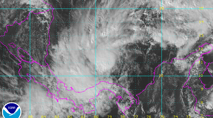
Satellite pictures show that disturbed weather in the Southwest Caribbean has strengthened into Tropical Storm Otto. Otto looks to be trapped in the Southwest Caribbean and will likely drift westward over the next few days. It is no threat to the United States or the Greater Antillies.
...DEPRESSION STRENGTHENS INTO TROPICAL STORM OTTO...


SUMMARY OF 100 PM EST...1800 UTC...INFORMATION
----------------------------------------------
LOCATION...11.5N 79.3W
ABOUT 175 MI...285 KM ESE OF SAN ANDRES ISLAND
ABOUT 305 MI...495 KM E OF BLUEFIELDS NICARAGUA
MAXIMUM SUSTAINED WINDS...50 MPH...85 KM/H
PRESENT MOVEMENT...STATIONARY
MINIMUM CENTRAL PRESSURE...1000 MB...29.53 INCHES


WATCHES AND WARNINGS
--------------------
There are no coastal watches or warnings in effect.

Interests in Nicaragua, Costa Rica, and the islands of San Andres
and Providencia should monitor the progress of Otto, since a
Tropical Storm Watch may be required later today or tonight.


DISCUSSION AND 48-HOUR OUTLOOK
------------------------------
At 100 PM EST (1800 UTC), the center of Tropical Storm Otto was
located near latitude 11.5 North, longitude 79.3 West.  Otto is
nearly stationary, and a west-southwestward to westward drift is
expected over the next couple of days.

Maximum sustained winds have increased to near 50 mph (85 km/h) with
higher gusts.  Additional strengthening is forecast during the
next 48 hours, and Otto could become a hurricane during the next
couple of days.

Tropical-storm-force winds extend outward up to 35 miles (55 km)
from the center.

The estimated minimum central pressure is 1000 mb (29.53 inches).


HAZARDS AFFECTING LAND
----------------------
RAINFALL:  Outer rain bands from Otto are expected to produce
rainfall accumulations of 3 to 6 inches across portions of
central and western Panama and southeastern Costa Rica through
Wednesday, with isolated totals upwards of 10 to 15 inches across
the higher terrain.  These rains could result in life-threatening
flash floods and mud slides.  Additional heavy rainfall may move
into portions of Costa Rica Wednesday night into Thursday as the
system approaches the coast.
JOESTRADAMUS HURRICANE SEASON GUEST FORECAST
FiOS1 News Weather Forecast For Long Island
FiOS1 News Weather Forecast For New Jersey
FiOS1 News Weather Forecast For Hudson Valley
NATIONAL WEATHER SERVICE SNOW FORECASTS
LATEST JOESTRADAMUS ON THE LONG RANGE
Weather App

Don’t be without Meteorologist Joe Cioffi’s weather app. It is really a meteorologist app because you get my forecasts and my analysis and not some automated computer generated forecast based on the GFS model. This is why your app forecast changes every 6 hours. It is model driven with no human input at all. It gives you an icon, a temperature and no insight whatsoever.
It is a complete weather app to suit your forecast needs. All the weather information you need is right on your phone. Android or I-phone, use it to keep track of all the latest weather information and forecasts. This weather app is also free of advertising so you don’t have to worry about security issues with your device. An accurate forecast and no worries that your device is being compromised.
Use it in conjunction with my website and my facebook and twitter and you have complete weather coverage of all the latest weather and the long range outlook. The website has been redone and upgraded. Its easy to use and everything is archived so you can see how well Joe does or doesn’t do when it comes to forecasts and outlooks.
Just click on the google play button or the apple store button on the sidebar for my app which is on My Weather Concierge. Download the app for free. Subscribe to my forecasts on an ad free environment for just 99 cents a month.
Get my forecasts in the palm of your hand for less than the cost of a cup of Joe!
![]()
![]()

MENTION JOE CIOFFI AND GET A 5% DISCOUNT