Tropical Storm Laura Tropical Depression 14 Hurricane Season Record Breaking Pace Continues
Recon reports as well as satellite loops show that Tropical Depression 13 is now Tropical Storm Laura making it the earliest L storm (12) we have every seen on record. Tropical Storm Warnings are now up for the Leeward Islands as well as for the Virgin Islands and Puerto Rico.
12 NOON LOCATION…17.0N 60.2W
ABOUT 210 MI…335 KM ESE OF THE NORTHERN LEEWARD ISLANDS
MAXIMUM SUSTAINED WINDS…45 MPH…75 KM/H
PRESENT MOVEMENT…W OR 270 DEGREES AT 18 MPH…30 KM/H
MINIMUM CENTRAL PRESSURE…1007 MB…29.74 INCHES
LAURA SATELLITE

A Tropical Storm Warning is in effect for Puerto Rico, Vieques and Culebra, U.S. Virgin Islands, British Virgin Islands, Saba and St. Eustatius, St. Maarten, St. Martin and St. Barthelemy, Antigua, Barbuda, St. Kitts, Nevis, Anguilla, and Montserrat.
A Tropical Storm Watch is in effect for The northern coast of the Dominican Republic from Cabo Cabron to the border with Haiti,The northern coast of Haiti from Le Mole St. Nicholas to the border with the Dominican Republic, The southeastern Bahamas and the Turks and Caicos Islands
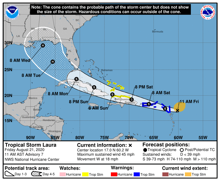
Nothing has changed regarding the forecast logic going forward. The big issue remains the track and whether the center crosses over all the big islands on its west northwest course or will it pass just north of the islands with the center remain over the ocean and giving it a higher chance for strengthening. The National Hurricane Center forecast track is a little south of the previous forecast and straddles the coastline of the islands. They think the center remains just offshore.
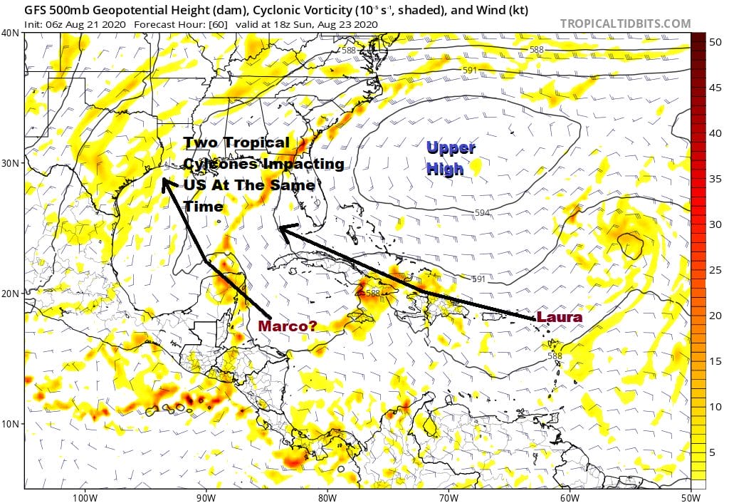
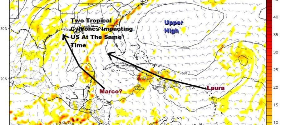
The strengthening upper high in the Atlantic is the driver here not only for Tropical Storm Laura but also for Tropical Depression 14 which is east of the Yucatan Peninsula and out over the open waters of the Caribbean again. This may lead us to see two tropical cyclones in the Gulf of Mexico at the same time next week and possibly making land fall within 24 hours of each other! The depression being further west leads us to believe the threat will be toward the Texas/Louisiana coast. Laura’s track is a little tougher to figure at this stage.
TROPICAL DEPRESSION 14

Tropical Depression 14 will likely strengthen to Tropical Storm Marco this afternoon as the center has now moved off the coast of Honduras and is back out over the open waters of the Western Caribbean. Water temperatures here are in the mid to upper 80s and the winds aloft are all light with minimal shear. This could strengthen quickly this afternoon into tonight before a landfall over the Yucatan Peninsula.
NOON LOCATION…16.6N 84.1W
ABOUT 165 MI…270 KM E OF ISLA ROATAN HONDURAS
ABOUT 325 MI…525 KM SE OF COZUMEL MEXICO
MAXIMUM SUSTAINED WINDS…35 MPH…55 KM/H
PRESENT MOVEMENT…NW OR 305 DEGREES AT 14 MPH…22 KM/H
MINIMUM CENTRAL PRESSURE…1008 MB…29.77 INCHES
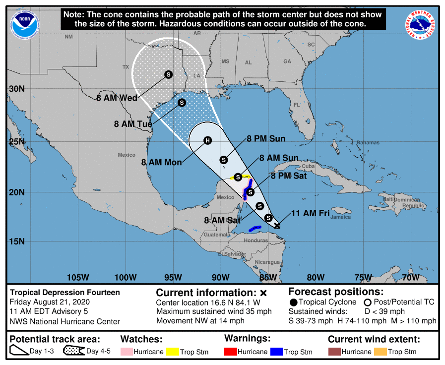
A Hurricane Watch is in effect for Punta Herrero to Cancun Mexico, A Tropical Storm Warning is in effect for Bay Islands of Honduras, Punta Herrero to Cancun Mexico. A Tropical Storm Watch is in effect for North and west of Cancun to Dzilam Mexico
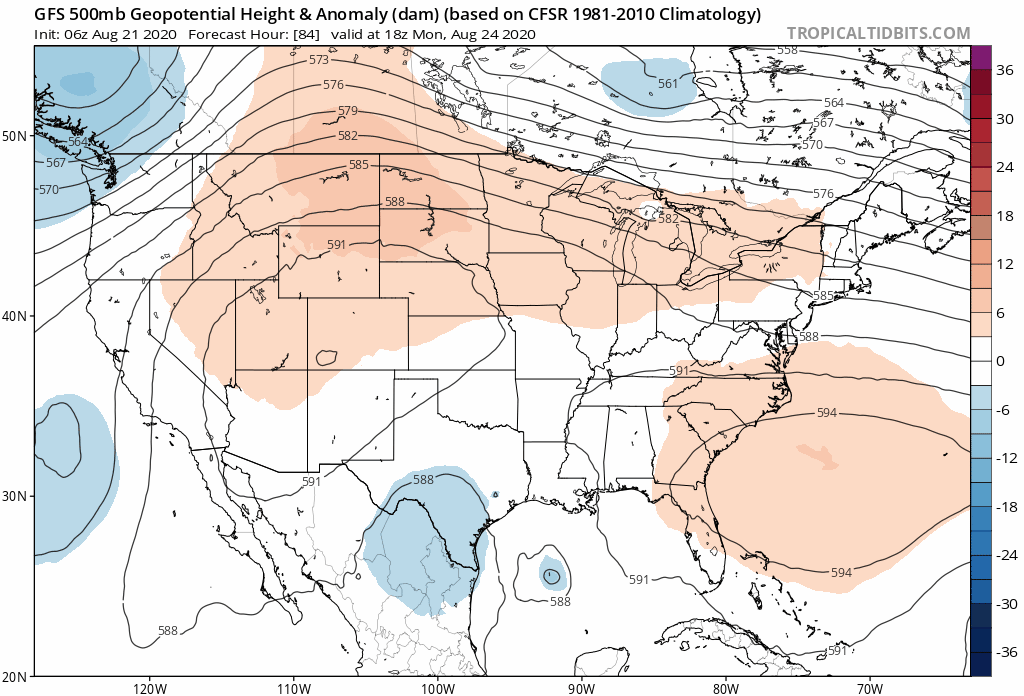
While we haven’t figured out the exact tracks of both systems we do know that the upper air pattern for next week DOES NOT favor these systems impacting our weather here in the Northeast and Nothern Mid Atlantic states in any way. The upper high that will be covering the Southern half of the US dominates and we have a busy west to east jet stream pattern north of 35 degrees north which will keep these systems from moving northward.
BE SURE TO DOWNLOAD THE FREE METEOROLOGIST JOE CIOFFI WEATHER APP &
ANGRY BEN’S FREE WEATHER APP “THE ANGRY WEATHERMAN!
MANY THANKS TO TROPICAL TIDBITS FOR THE USE OF MAPS
Please note that with regards to any severe weather, tropical storms, or hurricanes, should a storm be threatening, please consult your local National Weather Service office or your local government officials about what action you should be taking to protect life and property.