TROPICAL STORM FORMATION CONTINUES POSSIBLE NEXT 5 DAYS

TROPICAL STORM FORMATION POSSIBLE NEXT 5 DAYS
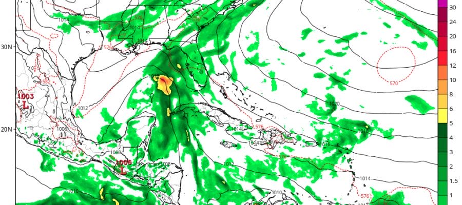
The National Hurricane Center continues to monitor two areas of disturbed weather. The one that is the most important to the United States is the system in the Northwest Caribbean. Disturbed weather there continues to increase and low pressure is going to form there over the next 24 hours. Systems that form here are often times slow to develop and this one is no different. Right now as you can see on the satellite loop below of the Guilf of Mexico there are no weather issues in this area at the moment.


You can begin to see the concentration of convection in the Northwest Caribbean. The curvature of the clouds suggests that conditions aloft are favorable for gradual development. Weather model tracks range from the European which continues to take this system straight west across the Yucatan and into the SW Gulf of Mexico. The GFS and Canadian envision a more northerly course with this into the Central Guif of Mexico.

The system in the tropical atlantic to continues to move westward along 5 degrees North latitude. It is so far south that on this track it would actually go into South America. It is rare enough to see a system this far south in August or September but it is almost unheard of in June. The system shows signs of organization and will continue to be monitored. If this forms into a tropical storm it could be among the earliest 9in the Eastern Atlantic) and furthest south ever observed since the satellite era.

JOESTRADAMUS HURRICANE SEASON GUEST FORECAST
FiOS1 News Weather Forecast For Long Island
FiOS1 News Weather Forecast For New Jersey
FiOS1 News Weather Forecast For Hudson Valley
NATIONAL WEATHER SERVICE SNOW FORECASTS
LATEST JOESTRADAMUS ON THE LONG RANGE
Weather App

Don’t be without Meteorologist Joe Cioffi’s weather app. It is really a meteorologist app because you get my forecasts and my analysis and not some automated computer generated forecast based on the GFS model. This is why your app forecast changes every 6 hours. It is model driven with no human input at all. It gives you an icon, a temperature and no insight whatsoever.
It is a complete weather app to suit your forecast needs. All the weather information you need is right on your phone. Android or I-phone, use it to keep track of all the latest weather information and forecasts. This weather app is also free of advertising so you don’t have to worry about security issues with your device. An accurate forecast and no worries that your device is being compromised.
Use it in conjunction with my website and my facebook and twitter and you have complete weather coverage of all the latest weather and the long range outlook. The website has been redone and upgraded. Its easy to use and everything is archived so you can see how well Joe does or doesn’t do when it comes to forecasts and outlooks.
Just click on the google play button or the apple store button on the sidebar for my app which is on My Weather Concierge. Download the app for free. Subscribe to my forecasts on an ad free environment for just 99 cents a month.
Get my forecasts in the palm of your hand for less than the cost of a cup of Joe!
![]()
![]()

MENTION JOE CIOFFI AND GET A 5% DISCOUNT