
Tropical Storm Force Winds Eastern L.I SE CT
TROPICAL STORM WARNINGS
EASTERN LONG ISLAND SOUTHEAST CONNECTICUT
HERMINE WEAKENING SLOWLY AND MOVING WESTWARD
Hermine continues to torture forecasters in the New York, New Jersey, Connecticut area. The cyclone is showing signs of slowly weakening which is what models have indicated it woud do. Some rain squalls passed through Eastern Long Island & SE Connecticut tonight and tropical storm force winds were observed in gusts through much of that area.

CITY           SKY/WX    TMP DP  RH WIND       PRES   REMARKS
Central Park   CLOUDY    78  55  44 NE13G25   29.99F
LaGuardia APRT CLOUDY    79  55  43 N20G30    29.95F
Kennedy INTL   PTCLDY    76  54  46 N22G31    29.95F
Newark/Liberty MOCLDY    77  56  48 N20G28    29.97F
Bronx Bot Gard   N/A     77  54  44 N18       29.97F
Wall St Helipt PTCLDY    79  59  50 S8        29.96F
Teterboro      MOCLDY    76  56  49 N9        29.97F
$$

NYZ177-179-078>081-060500-
LONG ISLAND NEW YORK

CITY           SKY/WX    TMP DP  RH WIND       PRES   REMARKS
Farmingdale    PTCLDY    75  53  46 N20G32    29.93F
MacArthur/ISP  CLOUDY    74  53  48 N23G36    29.90F
Shirley        CLOUDY    73  56  54 N15G35    29.91F
Riverhead      NOT AVBL
Westhampton    CLOUDY    70  57  63 N30G38    29.90F
Southampton      N/A     68  61  77 N17       29.85S
Bridgehampton  NOT AVBL
East Hampton   CLOUDY    66  59  78 N20G33    29.88F
Montauk          N/A     65  62  90 N20G39    29.88F
$$

NYZ052-065-067-060500-
HUDSON VALLEY

CITY           SKY/WX    TMP DP  RH WIND       PRES   REMARKS
White Plains   CLOUDY    74  50  42 N16G28    29.97F
Newburgh       CLEAR     68  61  77 CALM      30.06F
Montgomery     CLEAR     62  58  86 CALM      30.05F
Poughkeepsie   CLEAR     67  58  72 N3        30.02F
Albany         PTCLDY    66  59  78 N7        30.09F
$$

NJZ001-105-106-008-010-013-015-019>022-104-060500-
NEW JERSEY

CITY           SKY/WX    TMP DP  RH WIND       PRES   REMARKS
Newark/Liberty MOCLDY    77  56  48 N20G28    29.97F
Teterboro      MOCLDY    76  56  49 N9        29.97F
Caldwell       PTCLDY    74  57  55 VRB5      30.01F
Morristown     CLEAR     75  57  53 N6        30.00F
Somerville     CLEAR     71  58  63 N6        29.99F
Linden         FAIR      77  54  45 N12G17    29.99F
Sussex         PTCLDY    60  58  92 CALM      30.05F
Abdover          N/A     61  59  93 CALM      30.06F
Trenton        CLEAR     72  59  63 NW7       30.01F
Millville      CLOUDY    72  65  78 NW8       30.01F
Atlantic City  PTCLDY    71  60  68 NW10      29.98F
Wrightstown    PTCLDY    74  58  58 NW14G20   29.96F
Toms River     CLOUDY    76  58  53 N12G20    29.97F
Belmar         CLOUDY    78  57  48 N20G25    29.96F
$$

PAZ047>061-062-071-060500-
EASTERN PENNSYLVANIA

CITY           SKY/WX    TMP DP  RH WIND       PRES   REMARKS
Philadelphia   PTCLDY    77  58  51 N10       30.02F
Allentown      PTCLDY    69  58  67 N5        30.06S
Scranton       CLEAR     64  59  83 E6        30.12S
$$

CTZ002-004>006-009-010-012-RIZ004-006-007-MAZ004-011-015-060500-
SOUTHERN NEW ENGLAND
 IN CT

CITY           SKY/WX    TMP DP  RH WIND       PRES   REMARKS
Bradley INTL   MOCLDY    72  50  45 N18G32    30.02F
Hartford       CLOUDY    75  52  44 N21G33    29.99F
Danbury        CLEAR     71  50  47 N13       30.01F
Wtrbury/Oxford   N/A     70  50  49 N18G25    30.00F
Bridgeport     PTCLDY    75  52  44 N22G31    29.95F
Meriden        CLOUDY    74  51  44 N14G26    29.97F
New Haven      CLOUDY    73  50  44 N17G30    29.94F
Chester        CLOUDY    70  55  60 N18G32    29.95F
Groton         CLOUDY    67  58  72 N21G32    29.90F
Wilimantic     CLOUDY    68  58  70 NE26G37   29.99F


NAM GFS & the HRRR short range model all pretty much show the same idea tonight with a surface low drifting west and slowly weakening during the next few days. Models open the door for the possibility of another band of rain moving through on Tuesday. The HRRR model wants to bring a band of rain Tuesday afternoon as far west as coastal New Jersey, NYC, and Southern Westchester. The NAM model does the same thing. Since the models have been so unreliable, we are skeptical at best but can’t rule it out.
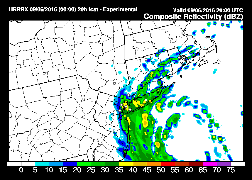
HRRR TROPICAL STORM FORCE WINDS FORECAST 4PM TUESDAY
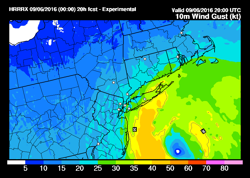
The wind field on the HRRR would suggest gale force gusts are possible on and off throughout the day over Long Island and off the New Jersey coast. The winds will slowly subside as we move into Wednesday as Hermine finally weakens and disappears.
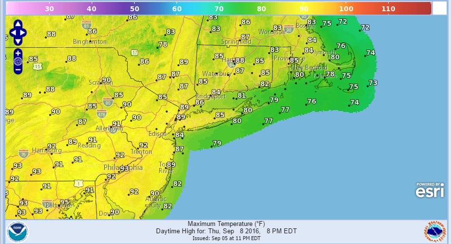
Longer term once Hermine is gone get set for some summer heat for Thursday and Friday with highs reaching the 90s in many locations both days over a large area. We will have to wait for the second of 2 cold fronts to cool it down. Once comes through Friday and the other on Sunday.
THURSDAY FORECAST HIGH TEMPERATURES
FRIDAY FORECAST HIGH TEMPERATURES

This is good because I’m planning on taking a couple of long deserved days off! No important rain is forecast other than an isolated shower or thunderstorm Friday and may a scattered shower or thunderstorm on Sunday as weak fronts push through on each of those days.
FiOS1 News Weather Forecast For Long Island
FiOS1 News Weather Forecast For New Jersey
FiOS1 News Weather Forecast For Hudson Valley
NATIONAL WEATHER SERVICE SNOW FORECASTS
LATEST JOESTRADAMUS ON THE LONG RANGE
Weather App

Don’t be without Meteorologist Joe Cioffi’s weather app. It is really a meteorologist app because you get my forecasts and my analysis and not some automated computer generated forecast based on the GFS model. This is why your app forecast changes every 6 hours. It is model driven with no human input at all. It gives you an icon, a temperature and no insight whatsoever.
It is a complete weather app to suit your forecast needs. All the weather information you need is right on your phone. Android or I-phone, use it to keep track of all the latest weather information and forecasts. This weather app is also free of advertising so you don’t have to worry about security issues with your device. An accurate forecast and no worries that your device is being compromised.
Use it in conjunction with my website and my facebook and twitter and you have complete weather coverage of all the latest weather and the long range outlook. The website has been redone and upgraded. Its easy to use and everything is archived so you can see how well Joe does or doesn’t do when it comes to forecasts and outlooks.
Just click on the google play button or the apple store button on the sidebar for my app which is on My Weather Concierge. Download the app for free. Subscribe to my forecasts on an ad free environment for just 99 cents a month.
Get my forecasts in the palm of your hand for less than the cost of a cup of Joe!

MENTION JOE CIOFFI AND GET A 5% DISCOUNT


