
Tropical Storm Don Moving To Windwards Tropical Storm Warnings
Tropical Storm Don Moving To Windwards
Tropical Storm Warnings
Tropical Storm Don is a compact tropical storm that continues to move westward. It remains under a favorable environment for strengthening and we have see seen a burst of thunderstorms this morning on the satellite loop. Tropical Storm Warnings remain in effect for the Windward Islands and they will be experiencing tropical storm conditions tonight as the storm moves into the Eastern Caribbean.

..DON EXPECTED TO MOVE THROUGH THE WINDWARD ISLANDS TONIGHT…
SUMMARY OF 800 AM AST…1200 UTC…INFORMATION
———————————————-
LOCATION…11.4N 57.0W
ABOUT 210 MI…335 KM SE OF BARBADOS
ABOUT 320 MI…515 KM E OF GRENADA
MAXIMUM SUSTAINED WINDS…50 MPH…85 KM/H
PRESENT MOVEMENT…W OR 280 DEGREES AT 18 MPH…30 KM/H
MINIMUM CENTRAL PRESSURE…1010 MB…29.82 INCHES
WATCHES AND WARNINGS
——————–
CHANGES WITH THIS ADVISORY:
None.
SUMMARY OF WATCHES AND WARNINGS IN EFFECT:
A Tropical Storm Warning is in effect for…
* Grenada
* St. Vincent and the Grenadines
A Tropical Storm Watch is in effect for…
* Barbados
* St. Lucia
* Bonaire
A Tropical Storm Warning means that tropical storm conditions are
expected somewhere within the warning area, in this case in the
next 24 hours.
A Tropical Storm Watch means that tropical storm conditions are
possible within the watch area, in this case in the next 24 hours.
Interests in Trinidad and Tobago, Aruba, and Curacao should monitor
the progress of Don.
For storm information specific to your area, please monitor
products issued by your national meteorological service.
DISCUSSION AND 48-HOUR OUTLOOK
——————————
At 800 AM AST (1200 UTC), the center of Tropical Storm Don was
located near latitude 11.4 North, longitude 57.0 West. Don is moving
toward the west near 18 mph (30 km/h). This general motion with
an increase in forward speed is expected through Wednesday evening.
On the forecast track, the center of Don will move across the
Windward Islands tonight, and then move westward across the
southeastern Caribbean Sea on Wednesday.
Maximum sustained winds are near 50 mph (85 km/h) with higher
gusts. Little change in strength is expected before the system
reaches the Windward Islands. Weakening is expected on Wednesday
while Don moves across the southeastern Caribbean Sea.
Tropical-storm-force winds extend outward up to 35 miles (55 km)
from the center.
The estimated minimum central pressure is 1010 mb (29.82 inches).
HAZARDS AFFECTING LAND
———————-
WIND: Tropical storm conditions are expected in the warning area
by late afternoon and tonight. Tropical Storm conditions are
possible in the watch area by tonight.
RAINFALL: Don is expected to produce total rain accumulations of
3 to 6 inches across Barbados and the southern Windward Islands
through Wednesday morning. These rains could produce
life-threatening flash floods and mudslides, especially in
mountainous areas.


As far as the long term future of Tropical Storm Don is concerned, the overall upper flow in the Caribbean would favor a westerly course which will have Tropical Storm Don skimming or moving just north of the coast of South America and then heading for the SW Caribbean. It would appear that the ridge to the north is very strong to continue a westward motion without much interruption.
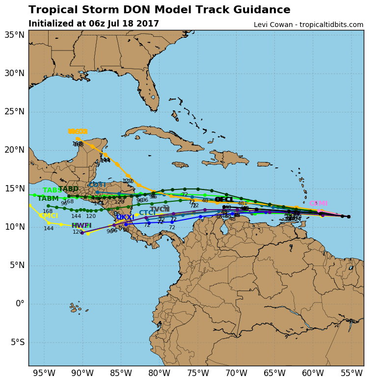
Strength on the other hand is more problematic and conditions in the Eastern Caribbean would suggest Tropical Storm Don weakening due to strong upper level westerlies but not all the models agree with this idea. The strength end of the hurricane forecast is always much more problematic.