
Tropical Storm Colin Heavy Rains Florida

Tropical Storm Colin Heavy Rains Florida
Will Straddle Southeast Coast Tuesday
Tropical Storm Warnings Extended Northward to South Carolina

Looking at the satellite loop this afternoon the center of Tropical Storm Colin remains exposed while heavy thunderstorms begin moving inland across Northern Florida. The main threat from this storm will be the rain as bands of heavy rain offshore continue to move inland. Radar is showing heavy rains continuing to build offshore and moving north northeastward.
Tropical Storm Colin Heavy Rains Florida Radar Loops


Jacksonville Florida radar shows rains already spreading northward into Georgia and South Carolina. Latest models show the storm tracking a little closer to the coast. The actual center will probably cross northeast Florida and go west of Jacksonville and Savannah Georgia before emerging over the ocean near or south of Charleston South Carolina.
Tropical Storm Colin Heavy Rains Florida GFS Forecast Tuesday
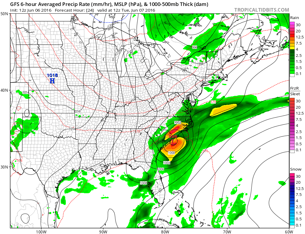
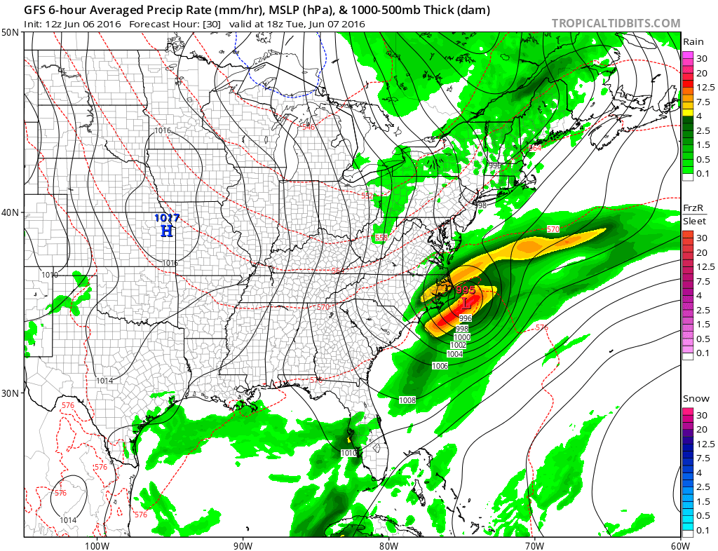
Today’s GFS model run takes the storm northeastward from there and out to sea. Some intensification is possible as Tropical Storm Colin interacts with a cold front moving offshore the Northeast and Middle Atlantic States.
Tropical Storm Colin Heavy Rains Florida Latest Advisory
TROPICAL STORM COLIN INTERMEDIATE ADVISORY NUMBER   5A
NWS NATIONAL HURRICANE CENTER MIAMI FL       AL032016
100 PM CDT MON JUN 06 2016

...BANDS OF THUNDERSTORMS WITH GUSTY WINDS APPROACHING SOUTHWEST
FLORIDA AND THE KEYS...


SUMMARY OF 100 PM CDT...1800 UTC...INFORMATION
----------------------------------------------
LOCATION...27.7N 86.5W
ABOUT 165 MI...265 KM SSW OF APALACHICOLA FLORIDA
ABOUT 245 MI...395 KM W OF TAMPA FLORIDA
MAXIMUM SUSTAINED WINDS...50 MPH...85 KM/H
PRESENT MOVEMENT...NNE OR 15 DEGREES AT 17 MPH...28 KM/H
MINIMUM CENTRAL PRESSURE...1004 MB...29.65 INCHES


WATCHES AND WARNINGS
--------------------
CHANGES WITH THIS ADVISORY:

None

SUMMARY OF WATCHES AND WARNINGS IN EFFECT:

A Tropical Storm Warning is in effect for...
* Indian Pass to Englewood
* Sebastian Inlet Florida to South Santee River South Carolina

Interests elsewhere along the southeastern coast of the United
States should monitor the progress of Colin.  Additional warnings
or watches may be required for parts of this area later today.

For storm information specific to your area, including possible
inland watches and warnings, please monitor products issued by your
local National Weather Service forecast office.


DISCUSSION AND 48-HOUR OUTLOOK
------------------------------
At 100 PM CDT (1800 UTC), the center of Tropical Storm Colin was
estimated near latitude 27.7 North, longitude 86.5 West. Colin is
moving toward the north-northeast near 17 mph (28 km/h). A turn
toward the northeast with an increase in forward speed is expected
by this evening, and a rapid northeastward motion is expected
overnight and Tuesday. On this track, the center of Colin is
forecast to approach the coast of the Florida Big Bend area late
this afternoon or evening, move across portions of Florida and
southeastern Georgia early Tuesday morning, and move near the
southeastern coast of the United States later on Tuesday.  However,
it's important to note that the strongest winds and heaviest rains
are well removed from the center.

Maximum sustained winds are near 50 mph (85 km/h) with higher gusts
in rainbands located well to the east and southeast of the center.
Little change in strength is forecast during the next couple of
days.

Tropical-storm-force winds extend outward up to 250 miles (400 km)
to the southeast of the center.

The estimated minimum central pressure is 1004 mb (29.65 inches).
Tropical Storm Colin Heavy Rains Florida Latest Weather Video
JOESTRADAMUS HURRICANE SEASON GUEST FORECAST
FiOS1 News Weather Forecast For Long Island
FiOS1 News Weather Forecast For New Jersey
FiOS1 News Weather Forecast For Hudson Valley
NATIONAL WEATHER SERVICE SNOW FORECASTS
LATEST JOESTRADAMUS ON THE LONG RANGE
Weather App

Don’t be without Meteorologist Joe Cioffi’s weather app. It is really a meteorologist app because you get my forecasts and my analysis and not some automated computer generated forecast based on the GFS model. This is why your app forecast changes every 6 hours. It is model driven with no human input at all. It gives you an icon, a temperature and no insight whatsoever.
It is a complete weather app to suit your forecast needs. All the weather information you need is right on your phone. Android or I-phone, use it to keep track of all the latest weather information and forecasts. This weather app is also free of advertising so you don’t have to worry about security issues with your device. An accurate forecast and no worries that your device is being compromised.
Use it in conjunction with my website and my facebook and twitter and you have complete weather coverage of all the latest weather and the long range outlook. The website has been redone and upgraded. Its easy to use and everything is archived so you can see how well Joe does or doesn’t do when it comes to forecasts and outlooks.
Just click on the google play button or the apple store button on the sidebar for my app which is on My Weather Concierge. Download the app for free. Subscribe to my forecasts on an ad free environment for just 99 cents a month.
Get my forecasts in the palm of your hand for less than the cost of a cup of Joe!
![]()
![]()

MENTION JOE CIOFFI AND GET A 5% DISCOUNT