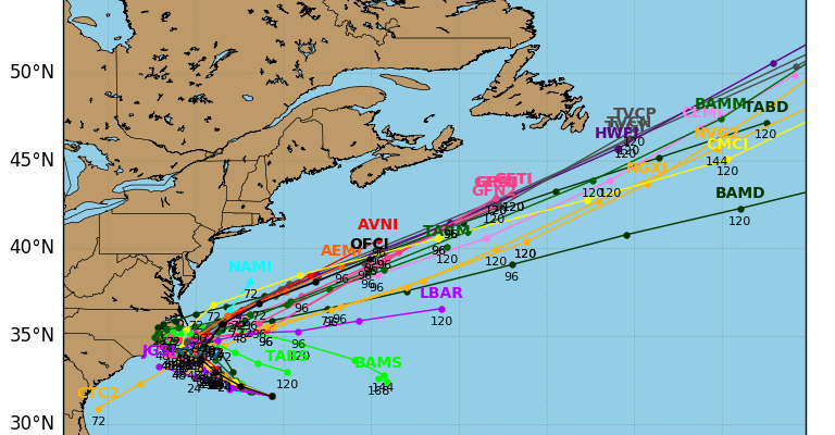
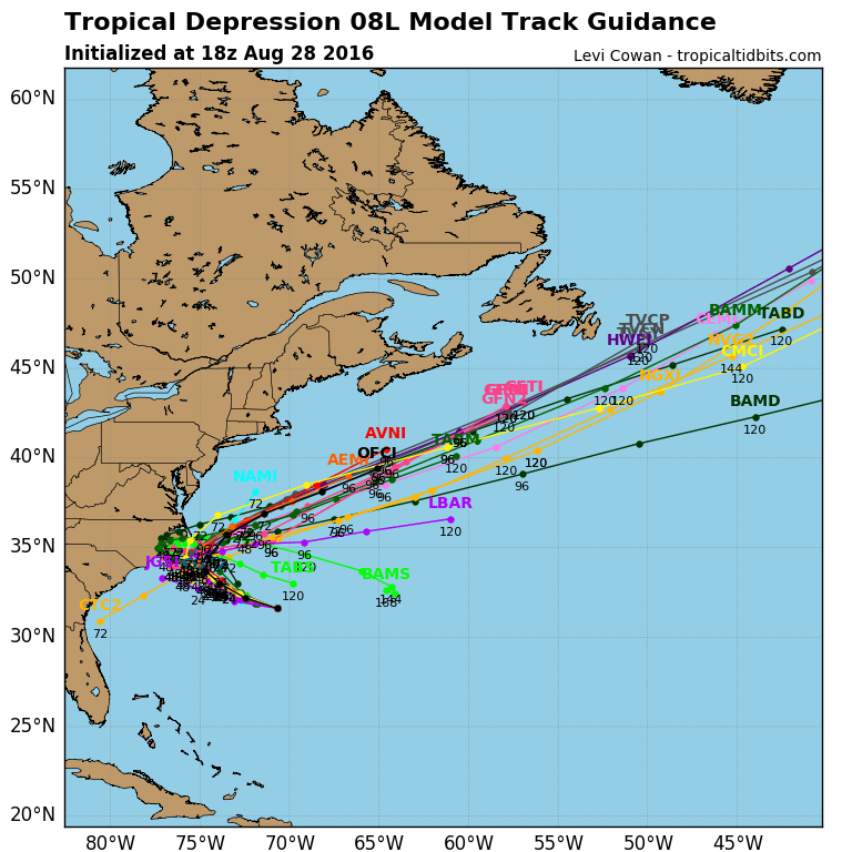
Tropical Depression 8 Moving West
TROPICAL DEPRESSION 8 Moving Westward
This afternoon Tropical Depression 8 has not become any better organized. In fact you can see the exposed circulation center on the satellite loop very well. Thunderstorms that were ovehead were blown to the west thanks to southeasterly shear and an upper low to the southwest of the depression.

...DEPRESSION MOVING WESTWARD...


SUMMARY OF 500 PM EDT...2100 UTC...INFORMATION
----------------------------------------------
LOCATION...31.8N 70.9W
ABOUT 355 MI...570 KM SE OF CAPE HATTERAS NORTH CAROLINA
ABOUT 360 MI...575 KM W OF BERMUDA
MAXIMUM SUSTAINED WINDS...35 MPH...55 KM/H
PRESENT MOVEMENT...W OR 280 DEGREES AT 9 MPH...15 KM/H
MINIMUM CENTRAL PRESSURE...1010 MB...29.83 INCHES


WATCHES AND WARNINGS
--------------------
There are no coastal watches or warnings in effect.

Interests along the Outer Banks of North Carolina should monitor
the progress of the depression.  A tropical storm watch may be
required for part of this area tonight.


DISCUSSION AND 48-HOUR OUTLOOK
------------------------------
At 500 PM EDT (2100 UTC), the center of Tropical Depression Eight
was located near latitude 31.8 North, longitude 70.9 West.  A turn
toward the west-northwest is expected tonight, followed by a turn
toward the northwest and a decrease in forward speed on Monday and
a slow northwestward motion on Tuesday.  On the forecast track, the
center of the cyclone will pass offshore of the North Carolina Outer
Banks late Tuesday.

Maximum sustained winds are near 35 mph (55 km/h) with higher gusts.
Some strengthening is possible during the next couple of days, and
the depression could become a tropical storm on Monday.

The latest minimum central pressure reported by an Air Force
Reserve Hurricane Hunter aircraft was 1010 mb (29.83 inches).


HAZARDS AFFECTING LAND
----------------------
None


NEXT ADVISORY
-------------
Next complete advisory at 1100 PM EDT.

$$
Forecaster Brennan
Tropical Depression 8 Forecast Next Few Days
Most of the model forecasts take Tropical Depression 8 west or west northwest over the next 2 days or so and the model guidance has this all clustered off North Carolina by Tuesday. However after that all models turn this to the northeast.
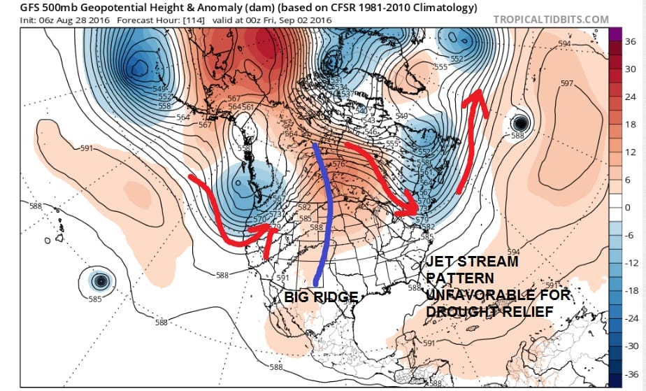
Given the fact that the flow across much of of the northeast will be from Canada (northwest to southeast) this track makes the most sense. There has been no change in the model track guidance this afternoon.
Tropical Depression 9 Forms In The Florida Straits

Tropical Depression 9 has formed in the Florida Straits this afternoon. We will have more on this in a separate post shortly.
FiOS1 News Weather Forecast For Long Island
FiOS1 News Weather Forecast For New Jersey
FiOS1 News Weather Forecast For Hudson Valley
NATIONAL WEATHER SERVICE SNOW FORECASTS
LATEST JOESTRADAMUS ON THE LONG RANGE
Weather App

Don’t be without Meteorologist Joe Cioffi’s weather app. It is really a meteorologist app because you get my forecasts and my analysis and not some automated computer generated forecast based on the GFS model. This is why your app forecast changes every 6 hours. It is model driven with no human input at all. It gives you an icon, a temperature and no insight whatsoever.
It is a complete weather app to suit your forecast needs. All the weather information you need is right on your phone. Android or I-phone, use it to keep track of all the latest weather information and forecasts. This weather app is also free of advertising so you don’t have to worry about security issues with your device. An accurate forecast and no worries that your device is being compromised.
Use it in conjunction with my website and my facebook and twitter and you have complete weather coverage of all the latest weather and the long range outlook. The website has been redone and upgraded. Its easy to use and everything is archived so you can see how well Joe does or doesn’t do when it comes to forecasts and outlooks.
Just click on the google play button or the apple store button on the sidebar for my app which is on My Weather Concierge. Download the app for free. Subscribe to my forecasts on an ad free environment for just 99 cents a month.
Get my forecasts in the palm of your hand for less than the cost of a cup of Joe!
![]()
![]()